Arctic Spatial Data Infrastructure
(Arctic SDI)
Arvo KOKKONEN, Jani KYLMÄAHO and Heli URSIN, Finland
| |
 |
 |
 |
|
| |
Arvo Kokkonen |
Jani kylmäaho |
Heli ursin |
|
1)
This paper will be presented at the FIG Working Week 2017 in
Helsinki, Finland, 29 May – 2 June. Understanding and responding to the
impacts of climate change and human activities in the Arctic, requires
accessible and reliable data to facilitate monitoring, management,
emergency preparedness and decision making. The Arctic Spatial Data
Infrastructure (Arctic SDI), was established to address the need for
readily available spatial data in the northern areas of the globe. The
paper focuses on the collaboration.
SUMMARY
Understanding and responding to the impacts of climate change and
human activities in the Arctic, a unique area among the Earth’s
ecosystems, requires accessible and reliable data to facilitate
monitoring, management, emergency preparedness and decision making.
Often it is difficult and costly to find, access and combine useful
datasets for a project since they are collected and managed by many
different organizations.
The Arctic Spatial Data Infrastructure (Arctic SDI), was established
to address the need for readily available spatial data in the northern
areas of the globe. The Arctic SDI is working with stakeholder
organizations to make their key data accessible, with a focus on the
Arctic Council and its working groups.
The Arctic Spatial Data Infrastructure is a collaboration between the
8 National Mapping Agencies of Canada, Finland, Iceland, Norway, Russia,
Sweden, USA and Denmark. The initiative is based on a voluntary
multilateral cooperation and focused on accessible authoritative
geospatial reference data. There is a signed Memorandum of Understanding
towards collaborative development of the Arctic SDI.
The Arctic SDI Geoportal is based on Oskari (http://www.oskari.org),
which is an open source framework - originally developed in the National
Land Survey of Finland - for browsing, sharing and analyzing of
geographic information, utilizing in particular distributed spatial data
infrastructures. The framework is used as a basis of the Arctic SDI
Geoportal as well as a significant number of other geoportals, Web GIS
applications and eGovernment services.
1. ARCTIC SPATIAL DATA INFRASTRUCTURE
Arctic SDI provides access to reliable, authoritative reference data
and facilitates stakeholders’ development and delivery of standardized,
interoperable geospatial data that can be made accessible via the Arctic
SDI Geoportal and other geomatics enabled tools and portals. The Arctic
SDI harmonized basemap is rendered using a common Arctic cartographic
specification to provide unified topographic view over the entire
Arctic.
Arctic SDI provides methodology for data sharing at all levels:
local, national, regional and global. It documents and applies
information management best practices, based on open international
standards, to build communities of practice to share data. Adoption of
Spatial Data Infrastructure (SDI) best practices builds interoperability
that breaks down data silos in support of multi-disciplinary
ecosystem-based research.
The Arctic SDI is an infrastructure that provides a web portal
with easy access to:
- geoportal for geospatial data viewing and discovery
- openly searchable metadata catalogue
- authoritative reference map as a Web Map Tile Service (WMTS)
- gazetteer search API
- thematic data from various organizations operating within
the Arctic Region
- easy-to-use tools for data dissemination
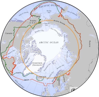
Figure 1: There are several different definitions on the
Arctic. In Arctic SDI each participant organization decides which area
of the country is included in Arctic SDI.
1.2 Participants and stakeholders
The Arctic Spatial Data Infrastructure is a collaboration between the
8 National Mapping Agencies of Canada, Denmark, Finland, Iceland,
Norway, Russia, Sweden and USA:
- Earth Sciences Sector of the Department of Natural
Resources Canada
- Danish Agency for Data Supply and Efficiency
- National Land Survey of Finland
- National Land Survey of Iceland
- Norwegian Mapping Authority
- Federal Service for State Registration, Cadastre and
Mapping of the Russian Federation
- Swedish Mapping, Cadastral and Land Registration Authority
- U.S. Geological Survey
Arctic SDI is based on a voluntary multilateral collaboration and
focused on accessible authoritative geospatial reference data. The
participant organisations have signed a Memorandum of Understanding
towards collaborative development of the Arctic SDI. The Arctic SDI is
working with stakeholder organizations to make their key data available,
with a focus on the Arctic Council and its working groups.
In 2009 the Senior Arctic Officials of the Arctic Council gave
formal support to the Arctic SDI. Arctic Council Working Group on
Conservation of Arctic Flora and Fauna (CAFF) 2015-2017 Work Plan in the
SAO Report to Ministers identified the Arctic SDI as a partner in the
CAFF Arctic Biodiversity Data Service (ABDS) and highlighted the
importance of a Pan-Arctic digital elevation map (Pan-Arctic DEM).
Arctic SDI provides methodology to achieve data sharing at all
levels: local, national, regional and global. It documents and applies
information management best practices, based on open international
standards, to build communities of practice to share data. Adoption of
Spatial Data Infrastructure (SDI) best practices builds interoperability
that breaks down data silos in support of multi-disciplinary
ecosystem-based research.
2. ARCTIC SDI GEOPORTAL
The Arctic SDI Geoportal is based on Oskari (http://www.oskari.org),
which is an open source framework - originally developed in the National
Land Survey of Finland - for browsing, sharing and analyzing of
geographic information, utilizing in particular distributed spatial data
infrastructures. The framework is used as a basis of the Arctic SDI
Geoportal as well as a significant number of other geoportals, Web GIS
applications and eGovernment services.
Arctic SDI Geoportals supports utilizing all Arctic SDI
services, such as the WMTS basemap, gazetteer search, metadata catalogue
and thematic data sources. Supported APIs are currently OGC WMS, WMTS,
WFS and CSW along with ESRI rest API.
Key functionalities include possibility to search for metadata,
place names and coordinates, map marker tool, map legend display, user
guide and a quick start guide along with common map GUI tools.
Registered users can take advantage of more tools: ability to
save map views and create embedded maps. Embedded maps are a powerful
tool for disseminating the information from SDIs without any programming
skills. Geoportal users can combine map layers to visualize the
phenomena of their choice and choose from a variety of tools to be added
on the map. The fully functional map client can be placed on any website
with context-related information by copy-pasting the map URL into the
website content management system. If any data source gets updated, the
latest data is readily shown on in the embedded map without user
intervention.
Oskari software is currently in incubation to become an Open Source
Geospatial Foundation (OSGeo) project. The Oskari collaboration network
actively facilitates various projects extending the software and
creating new innovative e-Government services. The network consists of
32 member organizations, of which 12 are private companies. The software
is under constant development by National Land Survey of Finland as well
as a number of other organizations.
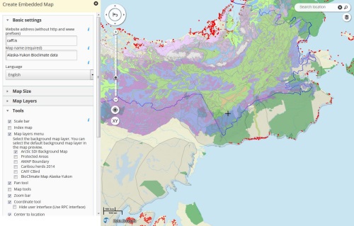
Figure 2: The Arctic SDI Geoportal can be used to create embedded
maps on other websites without programming.
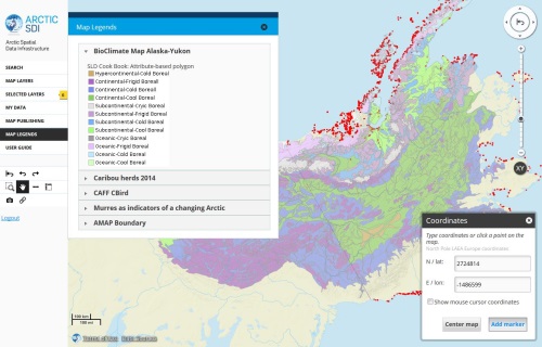
Figure 3: BioClimate Map Alaska-Yukon with a legend of
Bioclimate zones. Distribution of some Arctic fauna has been visualized
on top.
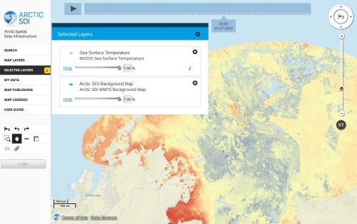
Figure 4: The Geoportal features a Time Series tool, which can be
used to visualize how several phenomena, e.g. Sea surface temperature
change over time in the Arctic.
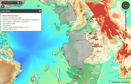
Figure 5: An embedded map showcasing the impact of Surface and
soil tempearatures, Circumpolar Thermokarst and Permafrost extent on
habitat of Caribou herds.
3. PAN-ARCTIC DIGITAL ELEVATION MAP (Pan-Arctic DEM)
Pan-Arctic Digital Elevation Map (Pan-Arctic DEM) -project is a
response to the need for high quality elevation data in remote
locations, the availability of technology to process big data, and the
need for accurate measurement of topographic change.
Pan-Arctic DEM is an activity under the U.S. Arctic Council
Chairmanship, implemented through the Polar Geospatial Center (PGC) at
the University of Minnesota. It is a USA National
Geospatial-Intelligence Agency (NGA) - National Science Foundation (NSF)
public-private initiative to automatically produce a high-resolution,
high quality, digital surface model (DSM) of the Arctic using optical
stereo imagery, high-performance computing, and open source
photogrammetry software.
When ready, the Pan-Arctic DEM will cover the entire Arctic. As of
December 2016, data for Alaska, Iceland, Baffin Island (Canada),
Svalbard (Norway), and Franz Josef Land and Novaya Zemyla (Russia) have
been completed. In the first quarter of 2017, PGC anticipates delivering
the western half of Greenland, Kamchatka, Ellesmere Island (Canada), and
the Faroe Islands (Denmark). Work will then focus on processing and
delivering the remainder of Canada and Russia, followed by processing
and delivery Sweden, Finland and Norway. Data users should anticipate
quarterly deliveries through the summer of 2017 until initial project
delivery is complete. All Arctic DEM data are available free to the
public for any use. Links to download Arctic DEM data are found on PGC’s
ArcticDEM website located at
http://pgc.umn.edu/arcticdem.
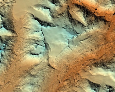
Figure 6: Pan-Arctic DEM
4. CAPACITY BUILDING
The Open Geospatial Consortium (OGC) led Arctic Spatial Data pilot
and SDI Manual for the Arctic both provide guidance on the planning,
management, development and maintenance of the Arctic SDI to the various
involved groups.
4.1 The Arctic Spatial Data Pilot
The Arctic Spatial Data Pilot (Arctic SDP) was initiated to
demonstrate the diversity, richness and value of providing geospatial
data using International Standards in support of Spatial Data
infrastructures.
Started on December 3, 2015, the Arctic Spatial Data Pilot is
sponsored by US Geological Survey and Natural Resources Canada, in
collaboration with the Arctic Spatial Data Infrastructure Participants.
This pilot demonstrates the value of standards in an environment that is
principally built as a system of systems, i.e. an Arctic Spatial Data
Infrastructure that integrates a number of existing systems as well as
individual services and data repositories.
Results are to be communicated via tutorials, technical
documentation, and a story-based video.
http://www.opengeospatial.org/projects/initiatives/arcticsdp
4.2 The SDI Manual for the Arctic
The goal of the SDI Manual for the Arctic is to provide information
and guidance on the planning, management, development and maintenance of
the Arctic SDI to the various involved groups, to provide best data
management practices, to identify policy and guideline requirements and
to demonstrate the value and benefits of using a SDI for efficient
monitoring and decision making in the Arctic. The manual addresses the
needs of three different audiences: high-level strategic decision
makers, Arctic data providers and distributors as well as end users of
Arctic data.
The key components of a SDI include institutional arrangements and
collaboration between participating organizations, data (including
framework and thematic spatial data), technologies covering all aspects
of the SDI, standards allowing for diverse data sources, services,
applications, and systems to operate with each other, and policies
covering the whole spatial data lifecycle and enabling users to exchange
data effectively and efficiently. These components are described in
detail in the manual. Additional considerations such as the open SDI
concept, community engagement, communications, and monitoring and
measuring impacts and benefits of the SDI are also discussed.
The SDI manual (version 1.0) is a dynamic document, which is expected
to be continually edited and updated to reflect the evolution of SDI
components and also the changing information requirements of the Arctic
stakeholders. It does not necessarily reflect all policies of each of
the participating national mapping agency.
REFERENCES
Arctic SDI - http://arctic-sdi.org/
https://arctic-sdi.org/index.php/strategic-documents/
Arctic Biodiversity Data Service -
http://www.abds.is/
The Arctic Spatial Data Pilot -
http://www.opengeospatial.org/projects/initiatives/arcticsdp
The SDI Manual for the Arctic -
https://arctic-sdi.org/index.php/strategic-documents/
https://www.youtube.com/watch?v=VtlTedwelAk
BIOGRAPHICAL NOTES
Arvo Kokkonen is Director General in the National Land Survey of
Finland since September 2012. He has also worked as a cadastral surveyor
and Survey Counsellor in the Ministry of Agriculture and Forestry. He
has experience in international projects and organizations, e.g. being
member of UNECE Working Party on Land Administration and EULIS.
Likewise, he has participated in the activities of EuroGeographics, PCC,
UN-GGIM and FIG. He is member of the Board of the Arctic SDI (Chair of
the Board from 1. June 2017).
Heli Ursin works as Head of International Affairs in the National
Land Survey of Finland. She has MSc degree in Geography, University of
Helsinki. She is active in international cooperation at regional
Nordic/ European level and also globally. She has been project manager
of international data projects focusing on SDI, in early days such as
Map of the Baltic Sea Region and later for EuroGlobalMap (EGM). She has
also been involved in European Location Framework and currently is the
National Contact Point for Arctic SDI in Finland.
Jani Kylmäaho gained an MSc degree in Geography from the University
of Helsinki, Finland. He is currently employed at the National Land
Survey of Finland, where his position is Head of Development for
topographic data production. He has been active in a number of
international initiatives and projects focusing on spatial data
infrastructures, including INSPIRE, European Location Framework and
Arctic SDI.
CONTACTS
Mr. Arvo Kokkonen
National Land Survey of Finland
Opastinsilta 12C
00520 Helsinki
FINLAND
Email: arvo.kokkonen@nls.fi
Web site:
http://www.maanmittauslaitos.fi/en
Ms. Heli Ursin
National Land Survey of Finland
Opastinsilta 12C
00520
Helsinki
FINLAND
Email: heli.ursin@nls.fi
Web site:
http://www.maanmittauslaitos.fi/en
Mr. Jani Kylmäaho
National Land Survey of Finland
Opastinsilta 12C
00520 Helsinki
FINLAND
Email: jani.kylmaaho@nls.fi
Web site:
http://www.maanmittauslaitos.fi/en
|


