Implementation of Marine Cadastre in Israel
Haim SREBRO, Israel
|

Haim Srebro
|
1)
This paper was presented at the FIG Working Week in Sofia, Bulgaria,
17-21 May 2015. Implementation of marine cadastre in Israel started in
2011. This paper elaborates on the implementation and plans
regarding a marine cadastre that will achieve a cadastral coverage over
the sovereign area of Israel, including a description of its
implementation in the approved marine settlement blocks as a result of
cooperation between Survey of Israel (SOI) and the Department of Registration and Land
Settlement (The Land Registry) under the Ministry of Justice.
SUMMARY
The first three marine settlement block plans, designated as marine
cadastre in Israel, were approved and signed as registered blocks in
October 2011. This was the first milestone of implementing a marine
cadastre in Israel following and concluding preparatory work for a few
years. Since then, an additional 13 marine blocks have been fully
registered and 13 are in an advanced stage before their final approval.
This reflects a fast growing interest and various activities regarding
the coastal and marine environment in Israel.
Israel is a coastal state. The marine areas of Israel in the
Mediterranean Sea include the territorial sea (TS) where it has full
sovereignty and the exclusive economic zone (EEZ) where it has partial
sovereign rights. In recent years the Survey of Israel (SOI) launched a
few relevant initiatives, including the following: coordinate based
cadastre (CBC) projects, one of which included transformation of 60 land
registration blocks to CBC along the coast line, 3D cadastre, and
land-marine Spatial Data Infrastructure. SOI published a series of
hydrographic charts and two atlases showing the formal coast lines to
support the Law of Protection of the Coastal Environment.
The rapidly developing activities regarding the search for gas and
oil in the above-mentioned Israeli marine areas, and the important gas
explorations, including the activities of developing a marine
infrastructure for the conduction and distribution of the exploited gas,
under the responsibility of the Ministry of Energy and Water, play an
important role in the development of the marine area. In addition, other
ministries advanced development plans in the marine area, including the
Ministry of Agriculture, the Ministry of Interior, the Ministry of
Transportation, among others.
These requirements were considered before launching the marine
cadastre initiative.
The final settlement of a marine cadastre depends on the final
delimitation of maritime boundaries between Israel and its neighbors. As
long as these boundaries are not concluded and agreed upon, the block
plans may cover the marine area except for the marginal blocks that
border the international maritime boundaries. In December 2010 Israel
and Cyprus agreed on the delimitation of their maritime boundary in the
EEZ.
This article elaborates on the above-mentioned situation and plans
regarding a marine cadastre that will achieve a cadastral coverage over
the sovereign area of Israel, including a description of its
implementation in the approved marine settlement blocks as a result of
cooperation between SOI and the Department of Registration and Land
Settlement (The Land Registry) under the Ministry of Justice.
1. INTRODUCTION
Israel is a maritime state that connects between the Mediterranean
Sea and the Red Sea. In addition, Israel shares the Dead Sea and
contains the Kinneret (Sea of Galilee) as an internal lake.
The traditional cadastre, since the beginning of the cadastral
surveys by the British authorities in the 1920s, referred only to a land
cadastre. This trend continued after the independence of the State of
Israel in 1948. Today, the land settlement covers 96% of the land area
of Israel. Most of the unsettled land areas are situated in the northern
part of the Negev (the South of Israel). The current rate of growth of
the population of Israel is very fast, probably the fastest in the
western world. This is reflected by fast urbanization, reducing the open
and green areas, as well as by utilization of the space above and
beneath the ground. This trend is an important reason for the initiative
of implementing a spatial cadastre (3D cadastre) in Israel (Shoshany et
al., 2004). Following a significant upgrade of technology at the Land
Registry, SOI and the Land Registry will hopefully push the 3D cadastre
forward.
Another phenomenon characterizing the rapid population growth and the
fast urbanization is the exploitation of the coastal areas. One of the
measures taken to protect the coastal area is the Law of Protection of
the Coastal Environment, the reference coast line for which in the
Mediterranean Sea was defined by the Director General (DG) of SOI
(Srebro, 2008) and afterwards in the Red Sea and the Kinneret in 2011.
In addition, there are rapid developments and activities in the sea
itself including the enlargement of ports, the construction of new
marinas, power stations, cables for communication, the licensing of gas
and oil drillings, etc.
In addition, there is a growing trend to construct part of the
infrastructure along the coast and in the sea, including a network of
gas pipes. This construction, under the responsibility of the Ministry
of Energy and Water, is augmented by the exploration of new large gas
fields in the sea opposite the Israeli coastline. The Ministry of
Agriculture promotes marine agriculture in Israeli waters. Long-range
planning takes into account the potential construction of artificial
islands, as well as an airport and roads in the Mediterranean Sea
opposite the coast.
A few years ago, following an initiative involving the transition to
a Coordinate Based Cadastre (Srebro, 2010), which included a pilot
project of block plans along the coast line, the DG of SOI decided to
begin activities towards establishing a marine cadastre as a
continuation of the land cadastre seawards.
2. MARINE CADASTRE
2.1 The scope of a marine cadastre
The definition of the term marine cadastre has two interpretations
that follow different scopes and concepts (Binns et al., 2003).
One reference to marine cadastre is similar to the land cadastre,
referring to boundaries: A marine cadastre is a system that enables the
boundaries of maritime rights and interests to be recorded, spatially
managed, and physically defined in relationship to the boundaries of
other neighboring or underlying rights and interests (Robertson et al.,
1999).
The other definition covers a wider scope: A marine information
system, encompassing both the nature and spatial extent of the interests
and property rights, with respect to ownership, various rights and
responsibilities in the marine jurisdiction (Nichols et al., 2000).
Furthermore, the concept of marine cadastre is developed later on to
the scope of the Multipurpose Marine Cadastre in the USA by NOAA Coastal
Services Center and the Mineral Management Service (MMS), as shown in
their homepage (www.csc.noaa.gov/mmc)
and by the FGDC Marine Boundary Working Group.
The US Maritime Cadastre is an information system that supplies web
services, based on authoritative data sources, integrating legal,
physical, ecological, and cultural data and information in a common GIS,
as well as rights, restrictions, and responsibilities (Fulmer, 2007).
The Canadian approach also refers to the multipurpose nature of the
marine cadastre and supports it by a marine geospatial data
infrastructure as part of the Canadian Geospatial Data Infrastructure
(Sutherland, 2003).
This trend was also adopted by the International Hydrographic
Organization, which decided in 2007 to establish a Marine Spatial Data
Infrastructure Working Group (MSDIWG) and prepared in 2009 a guidance
publication for Hydrographic Offices (IHO Publication C-17 – Edition
1.1.0 February 2011) regarding the marine dimension of National Spatial
Data Infrastructure (NSDI).
The Israeli approach until now, as practiced in the Sea of Galilee,
the Dead Sea, the Red Sea, and the Mediterranean Sea is to adopt the
limited scope of a marine cadastre, referring to the boundaries of
property rights and the rights of use to be registered. Thus, the marine
cadastre in Israel is actually a natural continuation of the land
cadastre; it follows the same principles and methods of implementation.
In parallel, SOI launched an initiative to build a marine GIS and the
DG of the Survey, who chairs the Inter Ministerial Committee for GIS,
declared in November 2011 the establishment of a sub-committee for
marine SDI.
In addition, an agreement on the delimitation of the EEZ was signed
between Israel and Cyprus in December 2010.
2.2. The marine areas
The UN Convention on the Law of the Sea 1982 (United Nations, 1983)
(Hereinafter: The Convention) supplies a general reference regarding the
sovereignty and rights of a state in the sea. The Convention defines a
few relevant maritime zones with reference to these rights:
Internal waters of a State include waters between the actual
coastline and straight baselines along the coasts. A State has full
sovereignty in internal waters and its rights over internal waters are
identical to its rights over the land area. In cases where internal
waters from the baselines landwards are established there is a right of
innocent passage (The Convention, Article 8).
The breadth of the territorial sea (TS) of a State covers the area
between the baselines along the coasts and a limit line not exceeding 12
nautical miles (NM) is measured from the baselines (The Convention,
Article 3) (see figures 1 and 2).
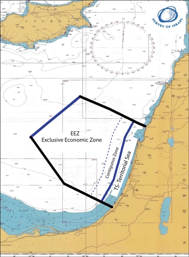
Figure 1: The maritime zones of Israel in the Mediterranean Sea (A
general approximated scheme. Background: Admiralty Chart 183)
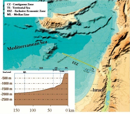
Figure 2: A Profile along the Israeli maritime zones in the
Mediterranean Sea
A State has full sovereignty over its territorial sea including the
air space over the territorial sea and the subsoil (The Convention,
Article 2). Vessels of other States have rights to innocent passage in
the territorial sea of a State (The Convention, Article 17).
The contiguous zone is up to 24 NM (12 NM beyond the TS) from the
baselines (The Convention, Article 33). The rights of the State in this
area do not refer to sovereignty but instead to the prevention and
punishment of infringement of customs, fiscal, immigration or sanitary
laws and regulations within its territory or territorial sea.
The exclusive economic zone (EEZ) of a State is up to 200 NM from the
coastal baselines (The Convention, Article 57), beyond which are the
high seas. The rights of a State in this area refer to living resources
like fishing. In addition, there are specific rights for mineral
resources and to exploitation of the seabed and sub-surface, which refer
to the continental shelf (CS) which may exceed the EEZ under specific
conditions in the open sea. There are rights of freedom of navigation as
well as flight rights over the EEZ. A State has only limited sovereignty
rights over the EEZ to use specific resources (The Convention, Article
56).
Other zones, which are specified in The Convention beyond 200 NM, for
example, with reference to the Legal Continental Shelf and other areas
(see also Nichols, 2003), are not relevant to Israel because in the case
of the State of Israel the EEZ is less than 200 NM. Thus, the State of
Israel has both rights to living resources (referring to the EEZ) and
rights to non-living resources (referring to the continental shelf) in
its EEZ.
Various types of rights are dealt with regarding the maritime zones
including navigation rights, customary rights, public access rights,
fishing rights, riparian rights, development rights, mineral resources
rights and seabed use rights (Sutherland, 2009).
The application of The Convention in Israeli waters: Israel is not a
party to The Convention, but views the majority of its provisions as
customary law.
2.3 The requirements for a marine cadastre
The first question that we have to refer to is: Why do we need a
marine cadastre?
The answer is the same as for the land cadastre. It is required in
order to settle ownership rights and rights of use. The Israeli cadastre
does not stop at the coast line. The more the marine space is utilized,
the more the settlement of these rights is and will be required. Since
the rights are attached to a specific space, an accurate definition of
this space is important. Owing to the lack of geographic features on the
surface of the sea, the proper way to define it is to define the
geographic spaces by coordinates. The recommended method of delimitation
and registration of rights is by implementing a coordinate-based marine
cadastre. This is also a preliminary answer to the question, how can a
marine cadastre be implemented.
The marine cadastre should support the State and the regionally
driven marine spatial planning initiatives regarding fishery,
transportation, recreation, energy production from wind and wave use,
marine agriculture, communication cables, oil and gas permits and
drillings, installations and pipelines, protection of marine ecosystems,
etc., encompassing both property rights and rights of use. Marine
boundaries are not demarcated but delimited by coordinates. Such
delimitation should prevent confusion, disagreement and conflicts.
In envisaging future development and requirements, 3D registration is
required to enable the management of rights on the sea surface, in the
water space, and in the subsoil space. This should also cover
archeological sites in the marine space.
The second question that we must refer to regarding the application
of a marine cadastre is: to which area should the marine cadastre apply?
A few government agencies are responsible for answering this
question. The ownership of State lands in Israel is under the Israeli
Land Authority. The registration of lands is under the responsibility of
the Land Registry in the Ministry of Justice and the responsibility for
the delimitation of lands for registration, as well as the delimitation
of the international borders of Israel, lies with SOI. The Ministry of
Foreign Affairs has its relevant responsibility for the international
borders of the State. Thus, the final decision regarding the
registration in the sea will be a result of cooperation and consultation
between a few Government offices. The decision of the DG of SOI
regarding this question was to begin technical preparations for a marine
cadastre as preliminary work for the final marine cadastre. According to
his view, in coordination with the view of the Director of the Land
Registry, the first priority should refer to the areas that are under
full sovereignty of the State. This should be the area over which a
marine cadastre would be applied first. This decision is based on the
relevance of the cadastre to ownership and development rights. Ownership
rights in a State are covered by its rules which are applicable to its
sovereign areas. These areas refer to the land area, the internal waters
and the territorial sea of the State. In the future, the question of
applying a marine cadastre in the Israeli EEZ should be dealt with,
since there are limited sovereign rights in this area. In practice, the
current main task in the EEZ is to delimit concession areas and to
manage and control permits and rights to drill and exploit minerals.
Following the experience of the USA, Canada and Australia, the
Israeli Marine Cadastre should definitely be applied to the Israeli EEZ
in the Mediterranean Sea, though it refers to limited rights. This
approach requires preparing an Israeli marine spatial data
infrastructure that should cover marine areas to the full extent of the
Israeli EEZ. Following this approach it is only a matter of
priority to apply the marine cadastre at first only to the Israeli
territorial sea area.
However, the legal method of registration of land settlement blocks
is followed, since Israeli law in general is currently not applicable to
the EEZ, and the current possibility to register marine settlement block
plans refers only to the territorial sea area.
Taking into account the multilayered marine space on the sea surface,
above it, and below it, the answer to the question "where", should
include the three-dimensional space down to the depth of the subsoil.
The third question is: When should a marine cadastre be implemented?
The answer is: as soon as possible. This is justified by the low cost
and the high speed of the "land" settlement process when an area is
owned by the State and is still mostly free of rights of use, and is
characterized by low density of man-made features. The planned
activities and the continuous process of development and exploitation of
land along the coast, which is also reflected in the fast growing value
of lands along the coast, indicate that in the future the creation of a
marine cadastre will be much more costly and will take much more time
due to the construction of various installations and utilities.
This answer has already been validated for the last four years by the
accelerated activities of the Ministries and Municipalities in the
marine area.
2.4 Practical analysis of the implementation of marine cadastre in
Israel
As already indicated, Israeli waters include four areas: the
Mediterranean Sea, the Red Sea, the Dead Sea, and the Sea of Galilee.
The Sea of Galilee is a lake within Israel. It already went through a
regular land settlement process, and was divided into 4 blocks as seen
in figure 3.
This lake is considered as a land area and is not covered by The
Convention. Furthermore, due to the temporary lowering of the water
level of the lake, its outer strip has already partially dried, and each
of the four blocks consists today of both a water and land area.
The northern part of the Dead Sea is divided by an international
boundary following the October 26, 1994 Treaty of Peace between Israel
and Jordan (Israel-Jordan Peace Treaty, 1994). The historical southern
part of the Dead Sea, has contracted and dried and is practically a
basin used for salt pans on each side of the international boundary
between Israel and Jordan (see figure 4).
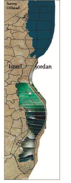
Figure 4: The settlement blocks in the
Dead Sea and Salt Pans |
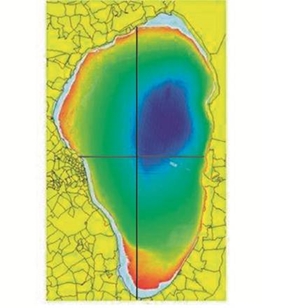
Figure 3: The land settlement blocks in the
Kinneret |
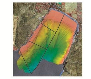
Figure 5: The land settlement blocks in the Red Sea |
Figures 3 and 5* make use of data from the National Bathymetry
Project.
(* Sade A.R., Hall J.K., Tibor G. et al (GIS Report GIS/03/2008) IOLR
Report IOLR/08/2008)
The Israeli Salt Pans' area is considered and dealt with to-day as a
land area. The Israeli waters of the Dead Sea are actually internal
waters. The land settlement in this area is dealt with like a land
settlement over the land area. The limits of the block plans in this
area, which are currently undergoing a land settlement process up to the
international boundary, are defined by coordinates, so it can be
considered as a practical (and not yet a legal) coordinate- based
cadastre.
The Israeli waters in the Gulf of Eilat - which is a branch of the
Red Sea also called the Gulf of Aqaba - are considered a territorial
sea. They lie between the coastline and the maritime boundary between
Israel and Jordan, which was concluded in 1996 following the 1994 Treaty
of Peace (Israeli-Jordanian Maritime Boundary Agreement, 1996). The
southern limit of this area has not yet been defined because Israel and
Egypt have not yet agreed on a maritime boundary in this gulf, but
following Article 15 of The Convention it should be delimited along the
equidistance line going from the terminus of the land boundary at Taba
(Srebro, 2009) up to the median line along the Gulf of Eilat. Since all
the Israeli waters in the Red Sea are considered territorial sea under
Israeli sovereignty, a marine cadastre in this area is applicable.
Actually, most of the area has already been settled as an extension of
the land cadastre (see figure 5).
2.5 Parallel relevant activities at the Survey of Israel
The basic definition of a marine cadastre includes the delimitation
of the cadastral blocks. Since the delimitation refers mainly to
coordinates on the water surface, the number of physical features that
are included in the block plans will be very limited, if any. But, since
the relevance of the cadastral delimitation, beyond the cases of special
installations and potential artificial islands, is to the multilayered
marine space, including the seabed and the subsoil, a proper mapping of
the seabed, including physical features in the relevant area, is an
important contribution to the cadastral division and to its application.
At present, most of the blocks will have no such information. The
blocks that will include some features will be the first line of blocks
that are near the coast and a few blocks where gas or oil drilling sites
plus transportation pipes or infrastructure cables that may exist as
well as fish growing sea farms.
Two other relevant activities are carried out during the last years
by SOI. One is the production of a series of hydrographic charts. SOI
has prepared 10 hydrographic charts covering the Israeli Territorial Sea
in the Mediterranean Sea. This includes one 1:250,000 chart, three
1:100,000 charts and seven large scale charts, in the framework of
cooperation with the Ministry of Transportation for the purpose of
safety of navigation. These charts contain a lot of data in the marine
area that can support a marine cadastre. The source data are collected
by the Survey of Israel, the Geological Survey of Israel, and the Israel
Oceanographic & Limnological Institute. An additional hydrographic chart
is being prepared for the Gulf of Eilat.
Another activity refers to the National Bathymetric Project, which is
run by a few agencies including the Geological Survey of Israel, the
Israel Oceanographic & Limnological Institute, the Survey of Israel and
others.
As analyzed by Ng'ang'a et al. (2003), bathymetry may play a
significant role in marine cadastre. This refers to the wide scope of
marine cadastre, including the safety of navigation, laying
communication cables, exploring and drilling for offshore oil and gas,
the location of underwater mineral deposits, and gaining an
understanding of the geological processes. It has a potential that has
not yet been implemented, which can be used in combination with other
geographic information to support marine boundary delimitation and
property rights. Bathymetry mapping is presented in this article in
figures 3 to 5.
In addition, when the use of mineral resources on the seabed and in
the subsoil develops, or when construction of special marine projects,
like artificial islands, develops, the need for implementing 3D or a
multi-dimensional cadastre will increase.
This requires the implementation of a CBC in the marine areas.
Therefore, taking into account the present supporting technologies and
infrastructure at SOI, the definition of the Israeli marine cadastre
should be based on coordinates.
This meets one of the present main initiatives at SOI, namely, to
transfer to a CBC. In addition, SOI has been promoting for a few years
an initiative of a 3D cadastre (Shoshany et al, 2004). This should be
integrated, when applied, into the marine cadastre wherever required.
The implementation of a CBC requires that all the boundaries of a
block be defined by coordinates (Srebro, 2010). A full definition of
blocks by coordinates in the sea is quite simple except for the case
near the limits of the marine areas of a state. This limitation refers
to the boundary between the marine area and the coastal area, in case
that such a boundary is not defined by dominating coordinates but
rather, by legal graphical documents. It also refers to the delimitation
of the territorial sea of a State and an adjacent State (usually an
equidistance line) and to the case of delimitation of the territorial
sea between a State and an opposite State (usually a median line).
3. THE MARINE AREAS OF ISRAEL IN THE MEDITERRANEAN SEA
The cases of the Israeli marine areas in the Kinneret, the Dead Sea,
and the Red Sea have been described earlier and it was concluded that
the limits of the block plans in these areas should be transformed from
legal graphical documents to legal coordinates.
However, the case of the marine area along the coastline of the
Mediterranean Sea is more complicated. The length of the coastline is
around 200km, along which exist 291 land settled block plans (see figure
6). The borders of 60 of these blocks have already been defined by
coordinates (Klebanov and Forrai, 2010).
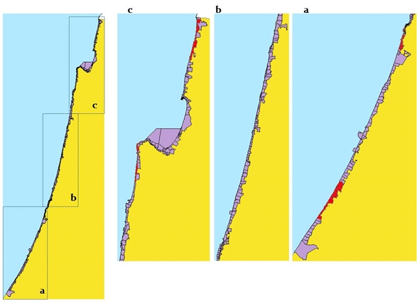
Figure 6 (a, b, c): Land blocks along the coast (In red: Coordinate
based Cadastre (CBC) blocks)
The Israeli TS in this area extends to a distance of 12 NM from the
base lines along the coastline. The EEZ of Israel in the Mediterranean
Sea cannot cover 200NM from the coast, because the distances between the
coasts of Israel and Cyprus, which are opposite coasts, are between
120NM and 200NM. Under customary international maritime law, the median
line between Israel and Cyprus, which is the outer limit of the Israeli
EEZ, is half way between the coastlines. As seen in figure 2, the
Israeli CS is included in the EEZ. In order to define a marine cadastre,
the TS should be sub-divided into block plans. The area close to the
coastline should be dealt with differently than the area that is more
distant, because most of the physical features and development in the
marine area are close to the coast. This refers to constructions like
ports, marinas, breakwaters, and pipelines. This area is also protected
by the law that protects coastal environments (Srebro, 2008).
As a result, it was decided to limit the size of the adjacent blocks,
whereas the more distant ones were designed roughly to a size of 5x5km
(see figure 7a) following the preliminary guidelines of the land
settlement officer. An optional plan takes into account the limits of
existing permits of exploration areas (see figure 7b).
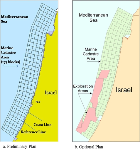
Figure 7: The suggested marine cadastre blocks in the Mediterranean
Sea
With reference to the delimitation of the blocks by coordinates,
there is a basic requirement to define the land block plans along the
coast by official coordinates. In order to achieve this, a pilot project
of CBC was launched in 2006. This project included four areas of 15
block plans each, spread along the coast in four typical environments:
one in a dense urban location, one in a semi-urban location, one in an
agricultural location and one in an open area. The results, which were
published in 2008, were 60 coordinate-based blocks, the coordinates of
50 of which were distributed to surveyors for optional use. The legal
cadastre in Israel still does not adopt coordinates for registration
(Klebanov and Forrai, 2010).
This enables defining coordinate-based marine cadastre blocks
neighboring the land coordinate-based block plans, but these are only
part of the 291 blocks along the coast line. In order to overcome this
problem, the DG of SOI decided to adopt a reference line connecting base
points on the coast by straight lines, to serve as a reference line for
the marine cadastre. The base points were surveyed by GPS and defined by
coordinates to serve as a digital border line between the blocks
adjacent to the coast and the "pure" marine blocks.
In addition, since the maritime boundaries between Israel and Lebanon
in the north and between Israel and Gaza Strip in the south are not yet
mutually agreed upon, the marine cadastre is planned in these areas
until and including the penultimate blocks, leaving the border blocks to
be settled following future political settlement of the delimitation of
the neighboring territorial sea areas. In addition, the DG of SOI
decided to prepare for settlement the marine blocks east of the
reference line landwards, which are opposite the land coordinate-based
blocks, the coordinates of which were determined in the CBC pilot
project. An example of such blocks is given in figure 8.
The area between the coastline and the straight reference lines holds
22 settled blocks which had already been settled due to existing land
development along the coast. The marine cadastre blocks, which refer to
this limited area, contain 63 blocks that are in a planning process, and
will be presented graphically in a 1:20,000 scale or larger for
registration.
The estimated number of blocks that are included in the planned
marine cadastre between the above-mentioned straight reference lines and
the outer limit of the Israeli TS is 175 blocks. Most of these blocks,
except the outer limits, cover as previously indicated 5x5 km (see
figure 7a). The blocks can be graphically represented in a scale of
1:20,000.
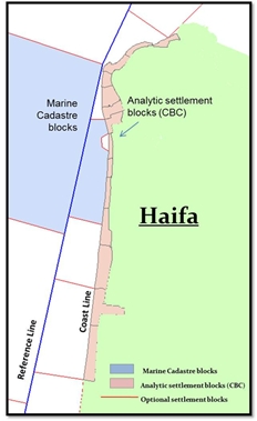
Figure 8: Example of CBC land block plans along the coast
On the 17th of December 2010 Israel and Cyprus signed an agreement
regarding the maritime delimitation line of the EEZ between the two
States.
The agreement was ratified in February 2011 and deposited with the
UN. This was an important step regarding the delimitation of Israeli
rights in the Mediterranean Sea.
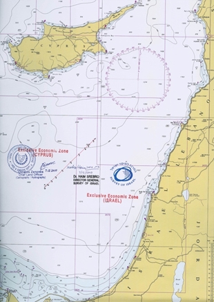
Figure 9: The EEZ delimitation line between Israel and Cyprus (On
Admiralty Chart 183)
This agreement fully coincides with the EEZ delimitation agreements
between Cyprus and Egypt (2003) and between Cyprus and Lebanon (2007).
The agreement left a level of flexibility for defining final common
tri-points between the relevant states at the edges of the delimited
line.
Following this agreement, one can see that the marine area in which
Israel has exclusive economic rights is in the magnitude of the Israeli
land area.
4. THE METHODOLOGY AND THE PRACTICAL IMPLEMENTATION
As mentioned earlier, the DG of SOI and the Director of the Land
Registry, agreed to promote a land settlement in the marine area. They
agreed to begin with a pilot project of a marine cadastre in the TS of
Israel, where Israeli law is fully applicable, and at a second stage,
explore the legal feasibility of initiating settlement proceedings in
the EEZ. In the EEZ Israel has limited rights according to customary
international law, among them the rights to exploit natural resources,
including gas and oil. The project included three marine cadastre
blocks.
The methodology
The recommended methodology of implementing a marine cadastre in
Israel follows the basic methodology used in the Israeli land settlement
process:
- General planning of the area to be settled;
- Public declaration by a land settlement officer regarding land
settlement in specified areas, announcing that potential claimers may
submit claims for ownership and for rights of use in these areas.
- Submitting claims;
- Publishing a table of claims;
- Checking and validating claims and their limits, including field
checks in the presence of the claimers;
- Concluding a table of rights by the land settlement officer and
publishing it;
- Legal appeals to a District Court (optional).
The technical and practical solution used by SOI for the
implementation was a result of the special circumstances associated with
the marine cadastre, where demarcation is not relevant and the
delimitation of boundaries is actually the process of defining
coordinates.
In order to minimize the problems of the external limit of the
relevant marine area seawards to be settled at this stage, this line was
defined as a line 12 nm from the base line along the coast, actually the
outer limit of the territorial sea. In order to have a proper limit
defined by coordinates, the chosen pilot area was one of the places on
land that underwent a process of transformation to coordinates in the
CBC pilot project (Srebro, 2010). These decisions limited the problems
because the marine blocks should be defined between polygons that are
well defined by coordinates. The area that was chosen for a pilot
project is an area south of the city of Haifa. The relevant coastal land
blocks along this area that were transformed to CBC in 2006 are shown in
Figure 8.
The traditional legal cadastral registration is still based on
graphical documentation. One should consider that the landwards limit of
the blocks along the coast line, which is the cadastral reference in
this area, does not coincide with the coast line existing in the
National GIS, as depicted from aerial photographs. However, it does not
coincide with the coast line defined by the DG to support the law for
the protection of the coastal environment (Srebro, 2008), which is
defined at a level of 0.75 m from the zero of leveling. It also does not
coincide with the exact low water line, which changes with time, or with
the straight base line in this area. In addition, the existing
administrative municipal line in the area does not coincide with the
cadastral reference (see figure 10).
The cadastral external line along the coast is a polygon connecting
the external (western) limits of the coastal land blocks. The result of
the decision to use the straight base lines along the coast as
boundaries of marine blocks created the first series of marine blocks
covering the internal waters between the outer limit of the land blocks
and the line connecting the coastal base points (the Reference Line in
figure 10).
The preference for the lateral limits of the first marine blocks was
to refer to existing municipal boundaries, but the municipal limits are
currently undergoing re-definition.
The size of the regular marine blocks between the reference line
connecting the coastal base points and the outer limits of the
territorial sea was defined roughly by 5x5 km cells following the
preference of the land settlement officer (Figure 11).
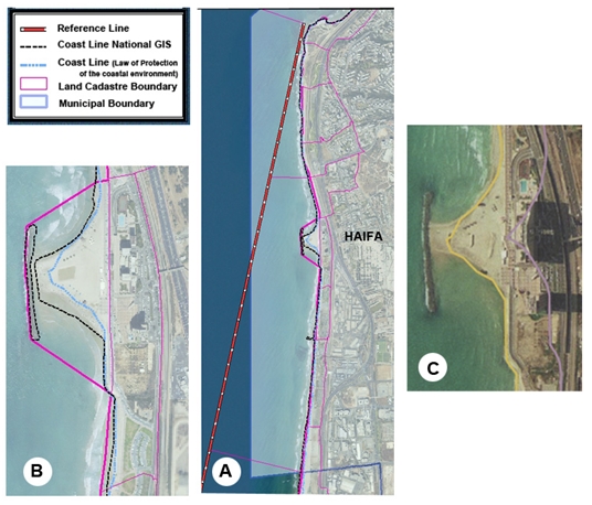
Figure 10:
A - Various existing reference lines along the coast
B - An enlargement showing the various reference lines
C - Coast line for the Law of Protection of Coastal Environment
The first legal step of the land settlement officer of the District
of Haifa was to declare publicly his intention to settle the specific
area in the near future. This declaration is under article 9 of the Land
Title Settlement Law. This declaration, which is published in Reshumot
(the official gazette of the Government), in newspapers and on the
internet, provides notices to people or organizations that have claims
regarding the area specified in the declaration; they can submit their
claims within the period specified in the public announcement (two
months). This declaration was published on July 12, 2011.
During the specified period, the land settlement officer has to
announce a formal visit to the area, to serve as an opportunity to show
all potential claimers the area of settlement and to give a chance to
any claimer to show the physical limits of his claim.
This procedure, which is a standard procedure in land settlement, was
also used for the settlement of the marine blocks. But since visual
physical features in the sea are rare, unlike the situation on land, an
alternative was found by organizing a sailing expedition to inspect the
marine blocks that were nominated in the published declaration.
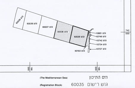
Figure 11: The scheme of the final cadastral blocks at the area of
the pilot project
Under another regulation, the formal visit to the area should be
publicly announced (in the printed and electronic media) 14 days in
advance. This was done and the sailing expedition to the area took place
on September 8, 2011.
As an expression of the "historical" moment in implementing a marine
cadastre in Israel, both the DG of SOI and the Director of Land Registry
and part of the relevant staff were on board the ship.
There were no private claimers who joined the expedition, but the
leading claimer attended it. He was a senior representative of the
Israeli National Land Authority, which is responsible for the management
of all State owned lands. This reflected the fact that the Government of
the State of Israel claims ownership over the area under Art.108 of the
1969 Land Law.
The trip took half a day following mainly the limits of the blocks,
but no physical evidences were found except a few buoys. The sea bed was
also explored by sonar and no unusual findings were registered there
either.
Following this formal visit to the area, the land settlement officer
made decisions regarding the limits of ownership and right of use in the
relevant blocks (specific strip parcels were assigned for a
communication cable in the area). SOI prepared final block plans
following the instructions of the land settlement officer. These block
plans were signed officially, as required by law, by the DG of SOI. Then
the land settlement officer published his decisions about the assignment
of ownership and rights of use within these blocks and the blocks were
registered at the beginning of October 2011. Following the successful
pilot project, SOI and the Land Registry continue their cooperation
regarding the settlement of marine blocks. At the end of summer 2014: 16
marine blocks were fully registered and an additional 13 marine blocks
are close to their final approval before registration. An additional 106
marine blocks are included in a bi-annual plan to begin the land
settlement process, not including the marginal blocks along the limits
of the territorial sea zone.
Figure 12: Status of southern marine cadastre blocks (white blocks -
finally registered blocks; green blocks – before final approval)
Following this process but with no direct connection, the DG of the
Ministry of Interior – the Ministry responsible for defining municipal
boundaries in Israel - nominated a committee to define the boundaries in
the sea of the municipal authorities along the coast line. This step
reflects the growing importance of the marine areas along the coast line
in general and especially for the cities and towns spread along the
coast line. It can propel and accelerate the process of land settlement
in the sea along the coast expanding the marine cadastre. Defining the
new municipal boundaries will influence the internal boundaries within
the first line of marine blocks. When the author appeared in front of
the committee, he recommended that municipal limits be defined in full
coordination with the limits of the cadastral block plans.
This will also require a change in the front series of land blocks in
order to adjust the limits of the blocks to the new external municipal
line either by enlarging existing blocks or by adding new blocks.
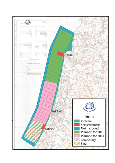
Figure 13: Plan for 2014-2015
In addition to this activity, a special committee is expected to be
formed to consolidate inter- ministerial activities, initiating a policy
document regarding the marine areas of Israel. The intention of the
author of this article is that this committee will also promote
collection and integration of data and knowledge, to become the basis of
a marine geospatial data base in which the marine cadastre will be one
of the layers, and thus create a Marine Geospatial Data Infrastructure
as part of the Israeli Spatial Data Infrastructure (ISDI). The marine
geospatial data base will be connected to the land geospatial
infrastructure to form a land-marine geospatial data base.
As part of this effort, SOI is in the process of converting the
hydrographic data included in its series of hydrographic charts to GIS.
One of the major challenges in this process is the different data
standards that are used for land and marine geo-information.
5. CONCLUSIONS
The author has adopted the definition of a marine cadastre regarding
the definition of cadastral borders and not the wide scope of marine
information (a multipurpose marine cadastre).
There is a definite requirement for both, but the issue regarding the
development of a marine spatial data infrastructure should and will be
dealt with separately. The rapid land development and exploitation of
lands along the coasts contribute to the trend of development of the
marine areas. The Israeli sovereign rights in the marine area should be
geo-referenced and referred to a cadastral infrastructure, as early as
possible, in order to obtain more benefits at lower cost as long as
there are no conflicting claims.
The strong requirement to utilize the marine areas of Israel and the
need to prepare the infrastructure for management of rights in this area
resulted in an initiative to implement an Israeli Marine Cadastre
regarding the definition of cadastral borders (Srebro et al., 2010) and
to prepare a plan for such an implementation.
Following this initiative and the following implementation plan,
there was a significant advancement. The Survey of Israel and the Land
Registry have already finished in October 2011 the process of settling
16 marine cadastral blocks and an additional 13 blocks await final
approval. The process of implementation was smooth, fast, and at a low
cost.
In parallel a few other activities connected to the marine
environment developed:
Israel signed a maritime delimitation agreement in the EEZ with
Cyprus; new large gas fields were discovered, requiring the construction
of a conduction and distribution network including coastal terminals; an
effort to delimit the municipal boundaries in the sea was launched,
coastal environment protection regulations and measures have been
implemented; and activities involving integrating governmental data into
the marine area as well as building a Marine Spatial Data Infrastructure
have been considered and practical measures have been taken. These
activities show the importance of fast implementation of a marine
cadastre as long as the cost remains low. The marine cadastre will
contribute to improve planning and coordination and can optimize
investments.
ACKNOWLEDGEMENT
The author thanks Advocate Alisa Caine the Director of the Israeli
Land Registry at the Ministry of Justice and Mr. Haim Laredo the Land
Settlement Officer of the District of Haifa. The author thanks the
people of the Survey of Israel (SOI) for their help with the data and
most of the figures: Mr. Ronen Regev, the Director General; Mr. Itzhak
Fabrikant, Deputy Director for Cadastre; Mrs. Orit Marom head of the
cadastral department; Dr. Yaron Felus, Chief Scientist; and Mrs. Eti
Benin, Mr. Baruch Peretzman, Mr. Elias Koifman, Mr. Hagi Ronen, Mrs.
Limor Gur-Arie, Mrs. Lea Ezra and Mrs. Rachel Saranga. The author thanks
Mr. Ronie Sade for his support with the figures based on the data of the
National Bathymetry Project and Spot data.
Note: The basic version of this article was written in 2012 when the
author still served as the DG of SOI.
REFERENCES
Agreement on the Delimitation of the Exclusive Economic Zone between
Israel and Cyprus (2010), signed in Nicosia on 17 December 2010.
Binns A., Rajabifard A., Collier P.A. and Williamson I., (2003),
Issues in Defining the Concept of a Marine Cadastre for Australia,
UNB-FIG Meeting on Marine Cadastre Issues, New Brunswick, Canada, 15-16
September 2003.
Binns A., (2005), Defining a Marine Cadastre – Legal & Institutional
Aspects, Marine Administration Workshop Understanding the Spatial
Dimension, Sydney, Australia, 1 December 2005.
Fulmer J., (2007), The Multipurpose Cadastre Web Map. Presented at
2007 ESRI Survey & Engineering GIS Summit, San Diego, California, June
16-19, 2007.
Byrne T., J.E. Hughes-Clarke, S.E. Nichols and M.I. Buzeta, (2002),
The Delineation of the Seaward Limits of a Coastal Marine Protected Area
Using Non-Terrestrial Subsurface Boundaries – The Musquash Estuary MPA.
Published in the Proceedings of the Hydrographic Conference, Toronto,
Canada, May 2002.
International Hydrographic Organization, (2011), Spatial Data
Infrastructures "The Marine Dimension", Guidance for Hydrographic
Offices, C-17 Edition 1.1.0., February 2011,IHB, Monaco.
Israel-Jordan Peace Treaty (1994), Peace Treaty between the State of
Israel and the Hashemite Kingdom of Jordan, 26 October 1994, UNTS 35325
Volume 2402.
Israel-Jordan Maritime Boundary (1996), The Maritime Boundary between
the State of Israel and the Hashemite Kingdom of Jordan, 18 January
1996, UNTS 35333 Volume 2403.
Klebanov M. and Forrai J., (2010), Implementation of Coordinate Based
Cadastre in Israel: Experience and Perspectives. Proceedings of XXIV FIG
Congress, Sydney, Australia.
Ng'ang'a S., Nichols S. and Monahan D., (2003), The Role of
Bathymetry Data in a Marine Cadastre: Lessons from Proposed Marine
Protected Area. US Hydrographic Conference, Biloxi, Mississippi, 24-27
March 2003.
Ng'ang'a S., Nichols S., Sutherland M. and Cockburn S., (2001),
Toward a Multidimensional Marine Cadastre in support of good Ocean
Governance, New Spatial Information Management Tools and Heir Role in
Natural Resource Management, International Conference on Spatial
Information for Sustainable Development, Nairobi Kenia, 2-5 October
2001.
Nichols S., Monahan D. and Sutherland M., (2000), Good Governance of
Canada's Offshore and Cadastral zone: Towards an Understanding of the
Marine Boundary Issues. Geomatica, 54 (4) 415-424.
Nichols S., Ng'ang'a S., Cockburn S. and Sutherland M., (2003),
Marine Cadastre: The basis for understanding the use and governance of
marine spaces. Presented on behalf of the Association of Canada Land
Surveyors to the Parliamentary Committee on Oceans, Canada, 17 February
2003.
Robertson B., Benwell G. and Hoogsteden C., (1999), The Marine
Resource: Administration Infrastructure Requirements, UN-FIG Conference
on Land Tenure and Cadastral Infrastructure for Sustainable Development,
Melbourne, Australia.
Shoshani U., Benhamo M., Goshen E., Denekamp S. and Bar R., (2004),
Registration of Cadastral Spatial Rights in Israel – A Research and
Development Project, FIG Working Week Athens Greece, May 2004.
Srebro H., (2008), Definition of the Israeli Coastline, FIG Working
Week 2008, Stockholm, Sweden, 14-19 June 2008.
Srebro H., (2009), The Definition of the Israeli International
Boundaries in the Vicinity of Eilat, FIG Working Week 2008, Eilat,
Israel, 3-8 May 2009.
Srebro H., (2010), On The Way to a Coordinate Based Cadastre (CBC) in
Israel, FIG International Congress, Sydney, Australia, 11-16 April 2010.
Srebro H., Fabrikant I. and Marom O., (2010), Towards a Marine
Cadastre in Israel, FIG International Congress, Sydney, Australia, 11-16
April 2010.
Stein D. and Taylor C., (2009), Working Towards a Multipurpose Marine
Cadastre, Workshop on Best Practices for Marine Spatial Planning, The
Nature Conservancy, Arlington VA, 2009
Sutherland M., (2003), Report on the outcomes of The UNB-FIG Meeting
on Marine Cadastre Issues Held at The Wu Centre, University of New
Brunswick Fredricton, New Brunswick, Canada 15-16 September 2003.
Sutherland M., (2009), Developing a Prototype Marine Cadastre. 7th
FIG Regional Conference, Hanoi, Vietnam, 19-22 October 2009.
United Nations, (1983), The Law of the Sea, Official Text of the
United Nations Convention on The Law of the Sea with Annexes and Index.
United Nations Publication, Sales No. E.83.V.5, New York, 1983.
BIOGRAPHICAL NOTES
Dr. Haim SREBRO received his BSc and MSc degrees from the Technion,
Haifa, in Civil Engineering and Geodetic Engineering and his PhD from
Bar-Ilan University. He was a teacher at the Technion and at Tel-Aviv
University. He served during the years 2003-2012 as the Director General
of the Survey of Israel and as Chair of the Inter Ministerial Committee
for GIS. He is a Co-Chairman of the Israeli-Jordanian Joint Team of
Experts since 1994, responsible for the delimitation, demarcation,
documentation and maintenance of the International Boundary within the
Joint Boundary Commission. Since 1974 he is a leading figure in the
boundary negotiations and demarcations between Israel and its neighbors
and signed the 1994 Peace Treaty between Israel and Jordan and the 1996
Maritime Boundary Delimitation. In 2010 he signed the Israel-Cyprus
Agreement on the EEZ Delimitation.
He was a member of ASPRS since 1978 and a member of ACSM and is a
member of the Israeli Society of Photogrammetry and Remote Sensing, the
Israeli association of Cartography and GIS, and of the Israeli Chambre
of Licensed Surveyors.
Dr. Srebro was the Conference Director of FIG Working Week 2009 at
Eilat.
He chairs the WG on International Boundaries of FIG Commissions 1.
He was the editor-in-chief of The New Atlas of Israel in Hebrew
(2008) and English (2011), and of the Atlases of the Israeli coast lines
in the Mediterranean Sea (2005) and in the Red Sea and in the Kinneret
(2011). He is co-author of the book 60 Years of Surveying and Mapping
Israel (2009), author of the book The Boundaries of Israel Today (2012),
Editor and co-author of FIG Publication No 59 on International Boundary
Making (2013), and author of a few books in Hebrew.
CONTACTS
Dr. Haim SREBRO
12 Teena St., Maccabim-Reut 7179902, Israel
Tel. +972-(0)50-6221400; Fax + 972-8-9263471
Haim.srebro[at]gmail.com
|


