Article of the Month -
April 2004
|
White Collar Malpractices in Cadastral Surveying and their
Effects on Secure Land Tenure and Sustainable Development
Alick R Mwamza, Zambia
The Author would
like to acknowledge the financial support from the FIG Foundation in
Copenhagen and material support from the Department of Geomatic
Engineering at the University of Zambia
(UNZA), without which carrying out this research would have been very
difficult.
 This article in PDF-format.
1. INTRODUCTION
Since 1992 when the world’s governments realised the need to protect the
environment, sustainable development was adopted as a general principle for
policies and actions that had a bearing in the environment, and one cannot
talk about environment without talking about land on which activities that
affect the environment mostly take place.
Issues of sustainable development strongly depend on surveying, planning
and management of land processes that deal with accessing and securing
tenure of land. Surveying is thus a fundamental activity on one of the major
components of developmental capital; land, with which Zambia as a country is
well endowed. However, in recent years some malpractices have been
encroaching into the professional practice of land surveying.
This research therefore endeavours to bring to the fore white collar
malpractices that have recently crept into the land delivery process which
if left unchecked would have untold effects on our much cherished
environment as has been seen in the mushrooming unplanned settlements where
the developers have no security of tenure at all and their activities on
land are not controlled in any way.
The system that facilitates acquisition of secure tenure on land is
flawed and the resulting security and development is unsustainable. In turn
the development undertaken thereon is not secure. Hence, the developers tend
to put up development that is not long term and which does not conform to
environmental needs for a sustainable earth.
A good cadastral survey approval system is thus a sure measure of
stability in development, as security of tenure of land on which it will
take place is assured. This was already realised at the United Nations 1992
Rio Conference on Environment and Development where the need to protect the
world’s environment was agreed with the concept of Sustainable
Development as a general guiding principle for policies and actions in a
large number of fields and sectors of society [FIG Agenda 21].
The World Commission on Environment and Development defined sustainable
development in their report on “Our Common Future” as, “Development that
meets the needs of the present without compromising the ability of future
generations to meet their own needs” [FIG Agenda 21]. This meant
protecting the natural environment and improving the social situation of the
poor and combating poverty.
Land surveying is therefore deeply involved in issues of profound
importance to sustainable development to improve the social situation of the
poor by combating poverty.
One such issue is that of land delivery and security of tenure without
which sustainable development cannot be realised. The issuance of a
Certificate of Title to land for a 99-year lease period is based on an
approved survey diagram compiled from a field survey carried out by a Land
Surveyor. In this context a Land Surveyor is one who is licensed to do so by
the Survey Control Board [Land Survey Act]. The Surveyor General or his
appointed Government Surveyors approves the survey after a rigorous
examination of the survey records submitted by the land surveyor. A
Government Surveyor is a licensed Land Surveyor who is in government
employment and is so appointed by the Surveyor General [Land Survey Act].
This research therefore looked at the current system of cadastral
surveying and its approval so as to identify any flaws and their effects on
secure land tenure and sustainable development and recommends feasible
remedies to mitigate the effects.
This research is of particular importance to sustainable development in
that it hinges on the security of tenure, which in itself is a critical
factor for sustainable development without which the developer may not
sustainably develop the land.
It is hoped that the findings of this research would help greatly enhance
the land delivery system that would be free of potential conflicts and
secure by an unquestionable Certificate of Title thereby guaranteeing
environmentally friendly development.
2. LAND HOLDING IN ZAMBIA
All land in Zambia was held under customary laws before the arrival of
the white settlers. This changed with the arrival of the colonialists who
wanted to hold land using the system they left at home, the British legal
system [Mulolwa 2002]. This brought in what was then called crown land,
which was held either on Freehold or leasehold, and native land under
customary laws.
Today land is still administered with this dual system with crown land
having changed its name to state land. In 1975, all freehold estates were
converted to 99-year leases through enactment of the Land (conversion of
titles) Act. Land could thus not be sold except for the improvements on it.
As such land in Zambia is held on leasehold in state land and under
customary laws in customary areas. However there is a provision for
converting customary land into state land with the consent of the customary
leaders (chiefs).
Land may also be held on a fourteen-year lease using just a sketch to
generally describe the land parcel in question. This lease is normally
looked at as just a facilitating tool for development as arrangements for a
longer lease are being made. There is also a 30 year lease given out based
on a sketch plan in resettlement schemes. A 30-year occupancy license is
also given within housing improvement areas under the Housing (Statutory and
Improvement Areas) Act, 1975. Occupancy licenses are given out by councils
who hold a block title to such land.
The longer lease is for a period of 99 years and can only be granted
after an accurate survey of the land parcel has been carried out, hence the
need for a survey diagram.
3. NEED FOR A SURVEY DIAGRAM
A survey diagram is one of the three cadastral plans that are part of the
survey records for a particular survey of a land parcel for purposes of
obtaining a certificate of title.
It is thus a document that contains geometrical, numerical and verbal
descriptions of one or more parcels of land, the boundaries of which have
been surveyed by a land surveyor and which document has been signed by such
land surveyor or which has been certified by a government surveyor as having
been compiled from approved records of a survey or surveys carried out by
one or more land surveyors [Land Survey Act]. It includes any document,
which prior to the commencement of the Land Survey Act had been accepted as
a diagram in the Lands and Deeds Registry or in the office of the Surveyor
General or his predecessors.
A diagram may therefore be needed when:
- One needs to get a 99-year lease for a newly offered parcel of land.
In this case a new survey is undertaken for the purpose.
- One needs to transfer from a 14-year lease to a 99-year lease. In this
case a new survey is undertaken for the purpose.
- One needs a separate title for a subdivision from a parent parcel of
land. In this case a new survey is undertaken to excise off a part of an
existing parcel of land.
- One needs to replace a lost 99-year lease. In this case a so-called
duplicate title is issued using diagrams that a recompiled from the
original approved survey records held by the Surveyor General. The
compiled diagrams are called Certified True Copies (CTCs) whose use is
conferred by authority under section 33 of the Land Survey Act.
4. CADASTRAL SURVEYING
Cadastral Surveying is concerned with the charting of land to accurately
define its boundaries for purposes of obtaining a certificate of title to
that land. In Zambia, cadastral surveying is governed by the Land Survey Act
under which a Survey Control Board, which regulates the practice of
Cadastral Surveying, is constituted.
The Land Survey Act restricts the practice of cadastral surveying to only
licensed surveyors who are called Land Surveyors. The Surveyor General may
appoint Land Surveyors in government employment as Government Surveyors.
Government Surveyors are the ones who approve cadastral surveys on behalf of
the Surveyor General, who is the top most Government Surveyor.
5. THE CADASTRAL SURVEY APPROVAL SYSTEM
 |
Since the cadastral diagram is a legal document, the
survey from which it is compiled is examined in the examinations section
of the Survey Department. The Chief Examiner heads this section. He has
about six other examiners under him.
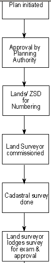
5.1 Flow of a Survey Job for Examination
Once the planning authority has approved development of particular
parcels of land, that plan is forwarded to the Ministry of Lands for
numbering after which advice on commissioning land surveyors to carry
out the survey is given to the client. The commissioned land surveyor
then carries out the survey, prepares the necessary records and lodges
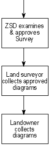
them for examination at the Zambia Survey Department (ZSD).
After examinations, the job is either returned to the land surveyor
for corrections or it’s passed on to the Government Surveyor for
approval. The Land surveyor then collects the approved survey diagrams
and hands them over to the client who uses them to request for their
Certificate of Title from the Lands Department.
All other materials (the written survey report, field book,
computations book, working plan and general plan) become public property
and remain with ZSD. These are used to update plans and for general
consultation by other land surveyors and others who may need the same
information. These records are kept in the Plan Room.
5.2 The Plan Room
The Plan Room is so called since this is where all the cadastral
plans and records are kept. At present all the data is in hard copy
form. Any data search for cadastral survey records takes place in the
plan room. The plan room also acts as a reception area for the ZSD. It
is usually the first point of call for all sorts of clients to the ZSD.
It is in the Plan Room that numbering of plans is done on request by
the Lands Department. Requests for Certified True Copies (CTCs) of
approved diagrams are also made in the Plan Room. The Plan Room, in
short, handles all sorts of requests pertaining to cadastral surveys and
filters them to particular sections, which deal with them.
It is therefore in the plan room that land surveyors lodge their jobs
for examinations and collect them after examinations. The plan room is
the focal point in the movement of the survey job for examination in
that after the job has been lodged for examination, it is registered and
given a survey record (SR) number and then forwarded to the examinations
section (Chief Examiner). After examinations, with necessary comments
(either return to land surveyor or pass to approval) the job is brought
back to the plan room where it’s forwarded to the next person in line.
FIG 1. A survey job's flow from planning to
collection of approved diagrams. |
After approval by the Government Surveyor, the Plan Room forwards the job
to the Reprographic Section to make a disaster copy for every approved
diagram, a process called “stat filing”, after which the job’s computer
records in the alphanumeric database are updated so as to now show the
survey details of that previously unsurveyed land. These are details like
diagram number, survey record number, land surveyor, extent, date surveyed
and so on.
After all this, the survey diagrams are then ready for collection by the
land surveyor who lodged them.
The plan room falls under the examinations section and is headed by an
examiner who is called the Plan Room Supervisor.
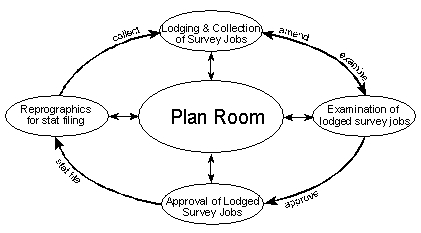
Fig. 2. Plan Room as the focal point in the survey job examination
process.
5.3 The Examinations Section
This section, which is headed by the Chief Examiner, who reports to the
Assistant Surveyor General in charge of Cadastral Services, is responsible
for scrutinising cadastral survey jobs before a government surveyor can
approve the survey.
The examination focuses on the correctness of the methods used,
preparation of reports and plans and whether carried out in accordance with
the Land Survey Act and its regulations. The job is either passed on for
approval or retuned to the land surveyor for amendments as per findings of
the examiner.
After being lodged, the survey job is put in a durable folder called a
Jacket upon which every officer who handles a particular part of the job
endorses his or her signature and comment. The contents of the Jacket are
also endorsed on it.
In addition, when survey jobs are lodged for examination and brought to
the Chief Examiner, he enters them in his register and distributes them to
his examiners who report back their findings to him so that he keeps track
of the examinations process noting the findings in his register. Jobs for
examination are therefore supposed to enter and exit the section through the
Chief Examiner.
6. THE PROBLEMS IN THE SYSTEM
The research focused on the period 1996 – 2003 for these malpractices
became noticed after land transactions were given monetary value. Previously
only developments on land could be sold and not the land itself on which the
developments were. This addition of monetary value to land became more
visible with the sale of government, parastatal organisations and council
houses to individuals who in turn sold them at inflated prices compared to
what they got them at.
At the same time there was an immeasurable demand for land to allocate to
those that did not benefit from the sale of houses. Prospective landowners
were thus ready to lay their hands on anything that appeared to be vacant
land at all costs. On the other hand, there was a cadre of prospective
malpractitioners ready to pounce both on the potholed system and the
desperate prospective landowners.
The major problem in the system now is therefore that procedures are not
followed at almost every level, leaving a lot of room for malpractices and
infiltration of the system by malpractitioners who survive by destabilising
the system further. This problem is not just a ZSD problem but also spreads
to other Departments of the Ministry since there is no system for counter
checking what is purported to come from the other Departments.
Consequently fictitious surveys, surveys carried out in offices,
existence of diagrams for non-existent land parcels and indiscriminate
issuance of CTCs through total abuse of section 33 of the Land Survey Act
became immensely noticeable. These malpractices thus gave rise to yet
another problem of rampant disappearance of survey records, mostly involving
such dubious surveys.
7. METHODOLOGY
The research started by reviewing a number of related articles to learn
and see what might have been done before in Zambia.
Minango (1998) in his thesis report outlined that, Dale (1976) included a
review of the cadastral system in Zambia in chapter 10 of his book; Lilje
and Nilsson (1976) looked at the backlog (reasons and consequences) of
cadastral surveys and their future demand in Zambia in a Swedesurvey
consultancy report; Mvunga (1980) traced the origins and development of land
tenure systems in Zambia; Bruce and Dorner (1982) looked at land tenure
issues in perspective, equity and productivity; Kagedal and Fagersten (1986)
delved into appropriate mapping techniques for land held under customary
tenure system; Fox (1989) covered issues of land delivery and Chileshe
(1994) looked at a low cost approach to cadastre and land registration for
land under customary tenure with emphasis on data acquisition.
Chilufya (1997) in looking at a possibility of an integrated cadastral
and land registration information system noted that delays in survey records
examinations were due to lack of trust the system had in Land Surveyors. In
other words, he alluded to the existence of white-collar malpractices in the
system, which one would say the examinations process sought to eliminate. He
recommended punishment for the erring land surveyors according to the law to
instil trust in the work they did. Chilufya (1997) also recommended that the
number of duplicate copies of plans maintained by the system needed to be
reduced. This pointed to the fact that the system cannot adequately monitor
activities based on these duplicate copies of plans due to their numbers and
might therefore create a fertile ground for the noted malpractices in the
system.
In addressing the issue of delayed examination of cadastral surveys,
Mulolwa (2002) recommends the use of an elaborate standard survey job
submission form with adequate information to aid quick determination of its
quality and hence approval.
The Lands Tribunal, set up under the Lands Act of 1995 to expeditiously
handle all matters relating to land, has so far not handled any dispute
which could directly be attributed to the problem of white collar
malpractices in cadastral surveying.
It can therefore be seen that no research has solely been dedicated to
identifying land survey malpractices inherent in the approval system or
indeed the registration system, let alone the effects of these malpractices
to secure land tenure and sustainable development. There was therefore need
for this research.
After literature review 112 survey records were randomly picked from the
Plan Room covering the period 1996 – 2003 (see table 1 and appendix 1). From
these records the following information was collected; parcel number,
examiner, survey record number and who carried out the survey (government or
private).
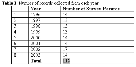
Since each surveyed and approved plan has a Survey Record (SR) number,
each parcel has an associated SR number. Accordingly, using parcel numbers
from the randomly selected survey records, a search was conducted in the
computer database to come up with the survey record numbers for those
parcels. Another check was also performed using the survey record numbers to
see if the survey records under scrutiny were for the same parcels of land.
This was done to determine the extent of the problem (see appendices 2 and
3).
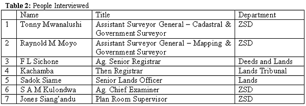
Interviews with some system operators were also conducted through which
some cases of these malpractices were identified. These interviews and mere
observations also helped understand the system of cadastral survey approval
and the public reception and complaints procedure now in place (see Table
2).
However, instead of focusing on who the perpetrators were the research
focused on identifying the flaws in the system and how they could be
remedied. This was necessitated by the fact that it was difficult to extract
information from people at a time when the country and the Ministry of Lands
in particular was embroiled in issues of corruption, which in essence are
the root cause of the very malpractices the research was focusing on. A
government task force pursuing perpetrators of economic plunder was already
in place and it was difficult for people to look at this research as an
exercise aimed at improving the land delivery system for sustainable
development and not a conduit for investigating people for prosecution.
8. FINDINGS
8.1 Record Searches
The searches done on computer using parcel numbers generated same survey
record numbers for most of the parcels, i.e. 76 of 112 representing 68%.
Therefore 68% exist both on ground and in the alphanumeric database. The
other 32% (36 of 112) generated comments ‘exist’ (23) and ‘not
exist’ (13). This is despite these survey records existing and being as
old as 5 years after approval. A possible explanation was given that:
- ‘exist’ means the parcel was proposed (numbered) to be surveyed
but may not have been surveyed yet, or if surveyed is not yet updated in
the database.
- ‘not exist’ means that the parcel was not proposed (numbered)
to be surveyed in the first place. As such it does not even exist in the
database.
The search by SR numbers did not yield much as the computer database
available has no capability to search using SR numbers. This was thus done
using the examinations register, which is very outdated.
8.2 Interviews and Observations
Through interviews, it was also discovered that:
- there is abuse of section 33 of the Land Survey Act. Section 33 allows
a government surveyor to approve a diagram or general plan if the same was
framed from approved survey records filed with the Surveyor General’s
Office (ZSD) or registered in the Deeds Registry without the signature
thereon of the land surveyor who signed the original general plan or
diagram if he is not available or unreasonably refuses to sign the general
plan or diagram so framed.
Through the use of this section fictitious or office surveys have been
conceived and diagrams produced with forged approving signatures or indeed
correctly signed by the unsuspecting government surveyor. Such surveys may
even bear record numbers of other parcels just to make them look complete
and real. This scenario presents itself on either a real parcel or indeed
a non-existent parcel.
- Existing parcels are usually those that were previously held on
14-year lease using a sketch plan as a description of the land parcel.
The malpractitioners then just sit in the office and scale off
coordinates from a topographic map and insert them on a diagram and use
other record numbers on it. It thus looks authentic and is presented for
approval.
- Non-existent parcels are used in the case of a desperate prospective
buyer who is promised a one-stop shop in acquiring the necessary
documentation for the promised parcel of land.
- There is indiscriminate production of CTCs using the same section 33.
- This is sometimes done to circumvent paying of survey fee due to a
land surveyor. In which case the malpractitioner pockets the small fee
for production of a dubious CTC.
- CTCs produced to facilitate a dubious transaction of selling one
parcel of land to more than one buyer and issuing all of them with
diagrams.
- Survey records pertaining to questionable diagrams disappear from the
plan room to obliterate incriminating evidence.
It was also discovered that persons who masquerade as land surveyors
perpetrate most of these malpractices aided by land surveyors who sometimes
endorse their work as authentic when not, at a small fee, the so-called
signing fee.
The plan room though acting as a reception area to ZSD is actually not.
As such a lot of confusion reigns presenting a fertile ground for the growth
of these malpractices. Owing to the plan room acting as a public reception
area to ZSD, it is difficult to monitor the movement of survey records,
which sometimes fall in wrong hands. Some officers in the Department also
personalise some survey records denying land surveyors and other interested
parties access to the same. Landowners instead of the land surveyor they
commissioned also usually collect diagrams directly from the plan room.
Movement of lodged survey jobs is not properly monitored such that some
jobs go straight to certain examiners with interest in them, a situation
which compromises quality of work produced. In fact it is in such cases were
records disappear soon after the job is approved. As such it is even
difficult for the chief examiner to know which jobs have come in and gone
out of his section for whatever reason.
At the ministry level it was found that there is no way of verifying what
Lands Department receives from ZSD as the diagrams are presented by the
landowners. The same is true for the Lands and Deeds Registry. Although
there exists an alphanumeric database in the ministry on matters of land,
most line officers have no access to it.
These flaws therefore make the perpetrated malpractices not easily
detectable at the right time at the right stage to quickly nip them in the
bud.
9. ANALYSIS OF FINDINGS
9.1 Record Searches
Searches that were conducted on randomly picked survey records came up
with 20.5% of records that were classified as existing but had not been
updated and 11.6% of the records that were classified as not existing.
- The records labelled ‘exist’ are parcels that were numbered but not
surveyed according to the computer database. Yet some of the parcels had
their surveys approved 5 years ago.
- The records labelled ‘not exist’ are for parcels that were numbered
and not indicated so in the database. They are thus not even supposed to
be surveyed according to the database records. Yet again their survey
records were approved.
There is only one computer terminal in the plan room from where the
alphanumeric database is updated and an excuse that it is inadequate may
therefore be advanced. Whereas this is true, it does not hold water in that
the so much talked about backlog cannot be properly ascertained since recent
records are updated and old ones not.
Therefore this anomaly in a system that is supposed to deliver secure
land tenure comes about because of lack of a clear-cut monitoring mechanism
to check that the flow of plans for numbering and approved survey records is
according to procedure. This is so in that there seem not to be clearly
defined roles for plan room personnel on who should make database updates
although both plan numbering and updating of surveyed parcels is done in the
plan room. The graphic updates done by the cadastral drawing office,
probably at the same time, cannot be said to cause the delay in the
alphanumeric database.
This lack of a monitoring mechanism thus leaves room for anyone to pick
the numbered plans or survey records before they are updated with or without
permission. The 32.1% of ‘exist’ and ‘not exist’ records could
therefore be as a result of malpractices.
Recommendations
- Clearly define the roles on who should be charged with the task of
updating the database. Such a person should also have unique rights to the
alphanumeric database, which all others might not be assigned.
- Increase the number of terminals in the plan room for this and other
purposes so as to ensure uninterrupted access to the database for the
person(s) carrying out the updates.
- Clearly define what kind of information is obtainable in the plan room
and from the Department of Lands so as to free the plan room from an
influx of people looking for information they could easily obtain from
Lands. This could be done by restricting the kind of information available
to the plan room to only survey issues.
- Put in place a clear watertight mechanism for monitoring the flow of
jobs handled in the plan room. Mulolwa’s (2002) integrated land delivery
architecture includes a job flow-monitoring module across the entire
process. Such a mechanism must have no room for shortcuts. This can easily
be done by ensuring that the current scenario where all survey jobs enter
and exit through the plan room only after all updates are completed.
- In case of survey jobs lodged for examinations, a monthly
reconciliation of the plan room records and actual jobs handled in the
examination section must be undertaken to account for jobs that circumvent
normal procedure.
9.2 Indiscriminate Use of Section 33 of Land Survey Act
Most if not all of the fictitious diagrams produced involve the use of a
name of a land surveyor who was or is in government employment. This is
because the loose application of this section in ZSD has largely facilitated
the malpractitioners use of this section. ZSD does not have enough licensed
surveyors and so it just uses names of the few available licensed surveyors
even for jobs done without their supervision, which is a clear contravention
of the provisions of the Land Survey Act. Such diagrams, which are not
signed by the land surveyor but just bear the land surveyor’s name, are many
from jobs carried out by ZSD in its 9 Regional Offices.
This is a flaw, which has been exploited to the fullest since one does
not need a land surveyor’s signature but just typing in the land surveyor’s
name suffices even for false surveys. The law only provides for use of
section 33 in recompilation involving previously approved survey records.
Section 33 reads, in part, that “provided that a general plan or
diagram may be approved if it has been framed from an approved general plan
or from an approved diagram or diagrams or from approved Survey Records
filed in the Surveyor General’s office or registered in the Registry,
without the signature thereon of the land surveyor who signed the original
general plan or diagram if he is not available or unreasonably refuses to
sign the general plan or diagram so framed”. It makes no mention of a
new survey being approved using the same section.
In fact section 33(2)a is categorical on the matter and states, “subject
to the provisions of section thirty-four, no general thereof plan or diagram
shall be approved unless it is prepared under the direction of and signed by
the land surveyor or land surveyors who carried out the respective survey”.
Section 34 only allows approval of unsigned records if they are for
consolidation purposes or boundary realignment only.
Recommendations
- ZSD must adhere to the provisions of the law. The reason why ZSD uses
the name of any land surveyor in government employment is not among those
provided for under section 33 of the Land Survey Act. ZSD must therefore
ensure that every Regional Officer in Charge is a land surveyor.
- To achieve the level of a land surveyor for every Regional Office, ZSD
must have a deliberate policy of grooming its young surveyors to obtain
licenses after a well-designed apprenticeship period.
- The Survey Control Board, though chaired by the Surveyor General must
clamp down on ZSD for indiscriminately using section 33 of the Land Survey
Act and contravening the law.
- In the meantime ZSD must restrict the use of section 33 to authority
given by the Assistant Surveyor General – Cadastral Services or the
Surveyor General only.
- For surveys involving living land surveyors, every effort must be
taken to ensure that they sign the documents as land surveyors are almost
always at ZSD looking for information to use in their work.
- The Land Survey Act, which was enacted in 1960, urgently needs a
severe surgery to rid it of undesirable clauses that facilitate
malpractices and infuse in new clauses that befit the 21st Century to take
care of the changing land administration and surveying technologies.
9.3 Indiscriminate Production of CTCs
Many people in Zambia dot not want to pay survey fees, which in fact, are
not so high. They thus trek to the plan room in the hope that they can
bargain for something less. When it is discovered that the parcel was
already surveyed but the owner says can only pay a small amount, CTCs are
usually the answer using the same notorious section 33 without the consent
of the land surveyor who could still be holding on to the diagrams waiting
for the no show parcel owner.
A mechanism is in place to ensure that the land surveyor accents to the
production of CTCs but it is not water tight.
Recommendations
- Applications for CTCs must go through the land surveyor who originally
carried out the survey to the Surveyor General. Where the land surveyor is
not available or unreasonably refuses to accent, then section 33 may come
into play.
- Reasons for production of CTCs must be properly laid out with
supporting documentation before accepting to issue them.
9.4 Missing Survey Records
Normally it is the records of dubious surveys, which go missing to erase
evidence of the same although some records are just personalised by some
people especially officers in ZSD. The reason being that they carry out
unauthorised surveys in certain areas but also simply for the love of
creating mini archives in their offices.
Recommendations
- A flawless job tracking mechanism is required to ensure that a jacket
position in the whole system is known at any point in time.
- Survey records must only leave the plan room after being signed for
indicating name, date and reason for collection, otherwise consult within
the plan room. At the end of the week an officer of the plan room charged
with the monitoring of the movement of the records must make a follow-up.
- Collection of and consulting of certain records must be restricted to
a specified group of people only such as land surveyors and line officers
in the ZSD.
- Only land surveyors or their authorised agents must be allowed to
collect diagrams from the plan room after approval.
- Clear and clean up the Plan Room. It is currently in a mess.
- Create a separate data review and printing section.
- Employ qualified staff in data and information management to run the
Plan Room.
9.5 Public Reception and Complaints Procedure
There is literally no public reception and complaints procedure system in
place. It is even difficult for someone coming to the Ministry for the first
time to find their way. Apart from the plan room functioning both as a
cadastral survey information archive and reception for land surveyors
lodging and collecting their jobs, it also acts as a public reception office
for not only the ZSD but also other Departments as people usually call there
first before being directed to the right office. This has bred a lot of
confusion in the whole system in that the roles of the plan room are not
well known as such and monitoring of its activities are difficult when there
is always an influx of the public looking for this or that.
Recommendations
- The Plan Room must be a cadastral survey information archive and a
specialised reception office for services needed by land surveyors and
line officers in ZSD. It will then be able to offer services that it
should to the right people and at the same time be able to monitor its
activities better than now.
- There must be therefore another public reception office for the ZSD or
Ministry that can act as a filter for all clients that visit ZSD or the
Ministry. This will also help in reducing incidences of tempting offerings
to various officers who at the moment directly come into contact with the
public. Mulolwa’s (2002) integrated land delivery architecture
incorporates such a front desk idea.
9.6 Checks within the Ministry
Knowing the output of other line Departments in the ministry is very
important if a conflict free product (title) is to be realised and dubious
records are to be quickly detected. At the moment the Lands Department that
receives the approved diagram to prepare a certificate of title, does not
know whether what they receive is authentic or not. As such there are even
cases where titles were prepared based on dubious diagrams.
Recommendations
- There is need for cross Department awareness campaigns to simply
enlighten those directly or indirectly receiving information or documents
from other Departments, which are inputs in their work. They need to know
what to expect and in what form. That way they will be able to tell the
difference between an authentic document and a dubious one.
- The present database system must be enhanced into an integrated GIS,
which both Chilufya (1997) and Mulowa (2002) advocate. Through such a
system, which integrates survey graphic data and land records, each
operator in the system of land delivery will have access to view the
records they need and take their action based on it. Certain safeguards
can be built in into the system to ensure integrity of information
therein.
For example, information about a parcel of land could be available from
the time an offer is made with additional information being added as it is
being generated such that at every stage any operator in the system would
know at what stage the process for a particular parcel is, thereby enabling
them to make an informed decision and advise the client accordingly. And
since information shall be input by people given rights to do so cases of
fraud will be easily detected and nipped. Decision-making shall also be
greatly enhanced with such an approach.
9.7 Unqualified People Carrying out Cadastral Surveys
Most of the malpractices in cadastral surveying are perpetrated by people
who are not qualified to do the job. These are normally people in the allied
professions who in the course of their work come across cadastral related
work. But instead of referring it to the experts they take it up and use
fellow unqualified people who use short cuts to get to the product required.
Such people have flourished because of the laxity in enforcing the law and
the sheer ignorance of those that give them such jobs.
Recommendations
- Enforce the provisions of the Land Survey Act by prosecuting those
that contravene the law.
- Mount awareness campaigns for the public using all effective media
channels to enlighten the public on the need to use land surveyors for
cadastral surveys. Further enlighten the public on what it takes to
produce a diagram and consequences of using unqualified people and dubious
methods to obtain a survey diagram. It is important to tell the public
that Cheap is usually expensive since the job, in case of a fictitious
survey, must be redone at the owners cost.
- Encourage land surveyors to get involved in educating the public,
especially the venerable groups e.g. women, on the process of getting
title to land as their contribution to society through which society’s
attitude could be influenced towards the concept of sustainable
development [FIG Agenda 21]. Such activities must therefore be recognised
by professional bodies as part of CPDs. Land surveyors must socially
integrate themselves in societies they live so that the public know what
they do best. Such involvement of land surveyors in public awareness
campaigns will thus go a long way in contributing to the achievement of
FIG Agenda 21.
10. EFFECTS ON SECURE TENURE AND SUSTAINABLE DEVELOPMENT
The effects of these white-collar malpractices in cadastral surveying are
immense and costly. In most cases land developers have had to lose out on
developmental projects they started on land that was later found to have
irregular documentation. In some cases building structures have had to be
demolished with no compensation at all or well-cleared farmland repossessed.
All because short cuts in the process were sought through resorting to
malpractices.
For example within this year not only was property lost in the Kalikiliki
demolitions, but also life. In 1991 and 2002 property was lost in the
Kanyama and Kamanga demolitions [Kalikiliki,
Kanyama and Kamanga are all unplanned settlements in Lusaka].
All because of the development were not secure and therefore unsustainable.
Had all these been secure with title based on properly executed cadastral
surveys, the loss could have been avoided.
In a country that is grappling with a high poverty levels, such loss of
scare resources through malpractices in the process of land delivery has a
very devastating effect in that the majority of the people are denied access
to land and security of tenure, which are very important prerequisites for
the provision of shelter for all. Consequently this translates into a great
denial of the development of sustainable human settlements in a country
where there is virtually no residual income. Hence a denial to break the
vicious circle of poverty which, is continually killing our society [FIG
Agenda 21].
In an effort to role back malaria, mosquito-spraying campaigns in
unplanned settlements failed due to lack of proper maps to plan and monitor
the process. Maps in such areas are usually a product of cadastral surveys.
Disease control is therefore a difficult task where illegality reigns.
Where landowners are spared of repossession or demolition, they have had
to foot the bill for a resurvey to correct the wrong, while losing out on
their first or indeed second payment of the dubious survey. All this at the
cost of diverting developmental resources into a process that could have
been done right the first time. The administrator of a named farm contracted
2 others who did not deliver the required service before she settled for the
author and paid all the three.
In cases where development takes place the economic effects are also
immeasurable since it becomes extremely difficult to turn such assets into
liquid capital thereby hindering acquisition of the much-needed capital for
new investments. Correction is usually at great cost both in terms of direct
payments for correction as well as in terms of loss of what might have been
a lifetime investment opportunity.
The greatest effect is that of loss of confidence in the land delivery
system by the main players such as development financing institutions. When
the documents that guarantee security of tenure become questionable,
securing financing opportunities for developmental projects becomes
difficult. Where they are accessed, it is again at an additional cost
because such players will ask for or carryout additional checks before
rendering any assistance.
In addition when confidence in a system is lost, illegality takes root
[Mulolwa 2002]. This then breeds anarchy in that development is unplanned
and haphazard. In such a scenario it therefore becomes difficult for central
or local government to control development in this age where even illegal
developers can seek protection of the law leading to lengthy and costly
legal battles in courts of law. Moreover, environmental concerns cannot be
addressed when development itself cannot be controlled. Even the much needed
provision of services and collection of revenue is difficult in such
circumstances.
All these effects sum up to an unsustainable development as everybody
loses confidence in the system. Environmentally, this has led to development
that does not take into account the well being of the surroundings within
which it is occurring. Hence degrading it to levels, which require diversion
of huge amounts of resources to correct. Yet such diverted resources could
otherwise be used to sustain society.
For example, the Kalikiliki Dam, at one time the home of a once vibrant
Lusaka Yachting Club is slowing being suffocated by encroachments of illegal
settlements. Many dambo (swampy) areas are now illegally built up;
disturbing the natural environment of any aquatic life there was in these
areas.
11. OVERALL RECOMMENDATIONS
Secure and sustainable development can only come about when there is
order in the land delivery system. At the moment there is a lot of anarchy
in this process that needs to be addressed urgently. Knowing that security
of tenure is a critical factor of sustainable development must propel us
further to ensure that the system that delivers that security is flawless to
build confidence and facilitate economic development.
The operations of the Plan Room and Examinations Section need to be
streamlined to make the survey diagram approval process watertight. In
addition, there is need to separate the plan room from a public gallery that
it now seems to be by providing a separate general public reception office.
The Surveyor General, the Assistant Surveyor General – Cadastral Services
and the Government Surveyor approving cadastral surveys must have access to
the enhanced database records (GIS) so that they are better informed as they
carry out their tasks. The same is true for all desk officers in Lands and
Registry Departments. This will only have an impact if the present system is
developed into a more transparent GIS that shall afford particular officers
only that information they need to work on or view. There is therefore need
to reengineer the present system on the lines recommended by Mulolwa (2002)
and Chilufya (1997). Such a GIS will stem a lot of malpractices with its
inbuilt safeguards, which to some extent the present system is lacking.
There is also an urgent need to overhaul the Land Survey Act, CAP 188,
and related legislation to facilitate smoothening the process of the entire
cadastral surveying system. In its current state, the Act is somewhat a
bottleneck in the land delivery system (The proposed amendments that were
proposed some 3 years ago have been overtaken by events). In line with the
pledge made in the 1996 Land Policy Document, the Ministry must facilitate a
quick review of this Act.
ZSD must stop abusing section 33 of the Land Survey Act. It has been a
major facilitator of the fictitious surveys that have occurred. ZSD must
therefore embark on retraining their young land surveyors towards getting
licensed. An increased number of land surveyors, from the present 30 country
wide, will also help curtail this dirty trend of mushrooming fictitious
surveys.
The Survey Control Board must also ensure that this scenario of about one
land surveyor per 350,000 inhabitants is greatly improved by devising
deliberate apprenticeship programmes for the profession. It is not enough to
just rely on a natural flow events when we are a country in crisis. The
Survey Control Board must also clamp down on all illegal activities in the
profession regardless of the perpetrators.
12. CONCLUSION
Poverty is a chronic disease eating away the fabric of our society and
affects both the haves and the have-nots. In Zambia, the single resource
that we have in abundance is land. Everywhere in the world economic
activities take place or start taking place on land. For us to economically
prosper, there must be security for rights held in land by various players
in the economy so as to facilitate economically sustainable development that
has the well being of the environment in mind.
This is achievable through the involvement of the land surveyor in
fulfilling his or her part in a conflict free land delivery process by
providing reliable survey data upon which a certificate of title, that
ensures secure holding in land, is based.
When this process is infested by malpractices security of tenure on which
sustainable development and hence economic empowerment depends, shall remain
a pipe dream and our society shall forever remain impoverished despite the
abundance of the major component of developmental capital – land. This
research has brought out issues that were previously just being talked about
in passing so that something can begin being done to nip this budding
problem before it gets out of hand.
Sustainable development depends on access to appropriate information at
the right time in the right form for critical decisions to be made. Some of
this information is delivered through cadastral surveying, which is in turn
used for property tax, land rent and rates collection, location of utilities
installations and provision of vital services such as ambulance and fire
services. The Lusaka Water and Sewerage Company limited, has shown that use
of cadastral information could be beneficial. Using cadastral maps based
GIS, the utility is able to sustain its operations through a billing system
that catches all its clients by location, timely location of faults to
properly maintain its infrastructure and to timely plan future developments
with an environmental friendly touch. These are some of the benefits of
properly functioning cadastral surveying system.
It is therefore hoped that the findings and recommendations of this
research shall become a vital piece in our quest to improve the
administrative, technical and legal aspects involved in the land delivery
process, especially those addressed in this research.
It is also hoped that, having sanctioned this research, the Surveyor
General shall employ its findings and recommendations into improving the
survey part of the land delivery system. The Ministry at large should also
use these findings to streamline the cross Department counter checking
system before using a particular product as an input in their own part of
the land delivery system.
ACKNOWLEDGEMENTS
The Author would like to acknowledge the financial support from the FIG
Foundation in Copenhagen and material support from the Department of
Geomatic Engineering at the University of Zambia (UNZA), without which
carrying out this research would have been very difficult. The willingness
to give information by all those interviewed is also highly acknowledged as
they made the research successful. The efforts, encouragement and assistance
of Chama Manda and Yamikani Mwanza in carrying out this
research are equally highly appreciated too. The encouragement the author
received from the Surveyor General, his assistant for cadastral services,
the School of Engineering Research Coordinator, UNZA and the President of
the Surveyors Institute of Zambia (SIZ) is also acknowledged. Dr A
Mulolwa is being acknowledged for reviewing this report at short notice
and indeed all those who contributed directly and indirectly.
REFERENCES
- Chileshe R A., 1994, A Low cost approach to Cadastral and Land
Registration for the customary Lands of Zambia with emphasis on data
acquisition, MSc Thesis, ITC, Enschede.
- Chilufya S M., 1997, From Manual to Integrated Cadastral and Land
Registration Information Systems – A Zambian New Legal Challenge, MSc
Thesis, ITC, Enschede.
- Dale P F., 1976, Cadastral Surveys within the Commonwealth, HM
Stationery Office.
- FIG Publication No. 23, FIG Agenda 21 2001 E ISBN 87-90907-07-8
- Land Survey Act CAP 188 of the 1995 Edition of the Laws of Zambia.
- Land (Conversion of Titles) Act, 1975, Laws of Zambia
- Housing (Statutory Improvement Areas) Act, 1975, Laws of Zambia
- Minango J C., 1998, Introducing a “Progressive” cadastre at the
Village as a Toll for Improving Land Delivery – A Case Study of the
Customary Areas of Zambia, MSc Thesis, ITC, Enschede.
- Ministry of Lands, 1996, Land Policy Document, Government Printers.
- Mulolwa A., 2002, Intergrated Land Delivery: Towards improving Land
Administration in Zambia, DUP Science, Delft University Press
BIOGRAPHICAL NOTES
The following team carried out this research.
Principal Researcher, Mwanza, Alick R (B.Eng, MSc). Lecturer in
the Department of Geomatic Engineering at the University of Zambia and a
holder of a Cadastral Surveying Practising License. Currently Vice President
of the Surveyors Institute of Zambia (SIZ) and Vice Chair for the Zambia
Association of Geographic Information Systems (ZAGIS). Was also Secretary to
an ad hoc committee that recommended amendments to the Land Survey Act.
Research Assistant: Chama, Manda (B.Eng). GIS analyst at the
Mining Sector Development Programme (MSDP) and first ever female Land
Surveyor from the University of Zambia.
Yamikani Mwanza. Geomatic Engineering 2nd year Student, University
of Zambia.
CONTACTS
Department of Geomatic Engineering
School of Engineering
The University of Zambia
P. O. Box 32379
10101 Lusaka
ZAMBIA
Fax + 260 1 29 55 30
Email: armwanza@eng.unza.zm
APPENDICES
 |


