Article of the Month - July 2020
|
Formalisation of Cadastral System Data
Dissemination Processes – Initial Studies
Josip Križanović and Miodrag Roić Croatia
 |
 |
| Josip Križanović |
Miodrag Roić |
This article in .pdf-format
(15 pages)
This peer review paper should have been presented at
the FIG Working Week 2020, Amsterdam, Netherlands. The aim of this paper
is to explore the processes of cadastral system data dissemination
regarding standardised and non-standardised uses of cadastral system
data.
SUMMARY
The land administration system and its key registers, cadastres and
land registers, play an important role in society when they function and
meet the goals set by the society. For the land administration system to
be effective it is important to have well-defined static and dynamic
components of the system. Static and parts of the dynamic components of
the land administration system are defined by the ISO 19152 LADM
standard, but for the purposes of efficiency and functionality of the
system, process optimisation is also important. The aim of this paper is
to explore the processes of cadastral system data dissemination
regarding standardised and non-standardised uses of cadastral system
data. Formalisation of processes is one way to explore which of the
existing classes of the LADM can be used in process modelling and which
ones need to be modelled in the future editions. By formalising the
processes of cadastral system data dissemination, the first step in
modelling the process is achieved, which is the identification of
participants and their roles in the processes of cadastral system data
dissemination. By identifying process participants and their
requirements, the user profiles can be developed in accordance with the
LADM standard, all for the purposes of future process modelling, which
is planned as an extension to the current edition of the LADM.
1. INTRODUCTION
Cadastres and land registers or, taken together, the cadastral
system, are public registers founded on the principle of publicity and
are obliged to grant access to registered information to a wide range of
users. In addition to citizens and public authorities, who recently have
been the most common users of cadastral system services and data, the
cadastral system is being used more and more in other economy branches,
such as the real estate market, spatial planning, taxation etc. and is
becoming the foundation of spatial data infrastructure. Many other
experts have upgraded cadastral system data with their new sets of data
which are derived from cadastral system data or created in accordance
with it. The right of access to public data is guaranteed by law in many
countries worldwide, and despite the fact that these countries and laws
are different, their goals are the same, namely population awareness,
democracy growth, fighting against corruption and raising
responsibilities of governing structures. Complex patterns, processes
and regulations slow down activities and raise discouragement for
dissemination of the cadastral system data (Roić, 2012).
Urbanisation, changing population demographics, advances in
technology and other major global trends are affecting every individual
and organisation around the world. Collaboration and data exchange are
very important in all economy branches including the land administration
systems. Cadastral system registers, as one of the key registers of land
administration systems, play a role in granting access to land
information and maintaining cadastral system data in accordance with
transactions that occur on land (Krigsholm, Riekkinen and Stahle, 2018).
Using cadastral system data is regulated by law; from the regulations
it is necessary to define user requirements by formalising the use
cases, which must then be checked in terms of whether they are in
accordance with both user requirements and regulations affecting
cadastral system data (Navratil and Frank, 2004).
The conceptual model describing land administration systems is known
as the Land Administration Domain Model (LADM), which became the ISO
19152 standard. The LADM represents the basis for modelling static
components of the system and these models do not include land
administration processes for initial data acquisition, data maintenance
and data publication. This is because these processes were considered to
be country-specific when the first edition of the LADM was prepared; a
generic and global approach was likely to be difficult to model. This
view may now need reconsideration (Lemmen et al., 2017). According to
the documents relating to the new scope of proposals for the LADM
revision, processes are yet to be modelled and are planned as an
extension to the current version of the LADM . It is also important to
acknowledge that these are only proposals and need to go through the ISO
consensus process before becoming part of the new standard (Lemmend et
al., 2019; van Oosterom et al., 2019).
Traditionally the focus of the research on land administration
systems was pointed towards defining static components of the system and
the provision of its data; therefore, it could be stated that there was
not enough research in the field of dynamic components of the land
administration systems, which are represented with methodologies of
updating large sets of data with transactional properties such as the
data stored in cadastral systems. It is more meaningful to talk about
cadastral systems than cadastres or land registers, as these systems,
due to their complexity and wide range of processes support the
interaction between land parcels, registration of land rights, valuation
and taxation of land and many other current and future uses (ISO, 2012;
Roić, 2012; Krigsholm, Riekkinen and Stahle, 2018; Vranić, 2018).
The aim of this paper is to formalise processes of standardised and
non-standardised uses of cadastral system data.
Standardised uses, in this paper the cadastral system excerpts, are
those defined by the legislation and required by other authorities; they
can usually be purchased from the cadastral system authorities.
Non-standardised uses are more user-specific, in terms of formats and
ways of accessing the data; they are also affected by legislation in
terms of what data can be used by others and for what purposes.
Formalisation of processes will be conducted using UML activity
diagrams, as UML has proven to be a good tool for modelling cadastral
processes (Arvanitis and Hamilou, 2004; Lisec, Miran and Šumrada, 2007;
Zevenbergen, Frank and Stubkjær, 2007; Vučić and Roić, 2014).
The main goal of process formalisation is to establish connections
with existing LADM classes for specific process parts and roles in order
to determine which classes are already modelled and which need to be
modelled in the future editions of the LADM. It is important to stress
that the processes formalised in this paper are somewhat country
specific but are formalised more in a general sense. Actors and process
elements can vary from country to country and are subject to different
laws and procedures. Models developed in this paper are based on
experiences of authors and do not represent the broader land
administration domain. The standardized cadastral system excerpt used in
this paper, as an example, was retrieved from the Joint Information
System (URL1), the platform where cadastre and land register (cadastral
system) are incorporated as part of the land administration system and
the stored data is electronically available to its users.
In order to gain insight knowledge regarding cadastral processes and
their data, thorough examination of previous research was conducted. The
examined research will also be mentioned in the paper. The paper is
organised as follows: in the first part, previous research on the topic
of processes will be listed, as will the results achieved thus far. In
the second part of the paper user requirements, activities and cadastral
system data will be described. The next part will include the
formalisation of the cadastral system data dissemination processes and
connection with the LADM. Paper ends with a discussion and conclusion
regarding the results achieved.
2. RESEARCH OF CADASTRAL PROCESSES
This paper focuses on one domain of cadastral system dynamism, and it
is represented by the dissemination of the data. To date, however, most
of the research on cadastral systems has been pointed towards static
components (the Core Cadastral Doman Model and later the LADM) and
provision of data, focusing more on technical and legal issues of the
system.
A solid basis for process modelling in cadastral systems was provided
by the COST Action G9 ‘Modelling Real Property Transactions’
(Zevenbergen, Frank and Stubkjær, 2007). COST Action G9 provided
comparative analysis of the economic efficiency of transactions in the
real estate market and connections between costs of transactions and
various national practices regarding real estate processes. Important
results from aforementioned action were the definition of terminology,
legal and technical correctness criteria, efficiency of transactions
(direct and indirect) and general process stages.
Navratil and Frank (2004) analyse cadastral systems (types,
organisation, data and stakeholders) and the processes that affect them.
They define two general types of processes in cadastral systems, namely
inscription and retrieval of data. Inscription adds new documents to the
register and retrieval of data returns information to the user. The
authors stated that data requests must allow different keys, because it
is not granted that there is a single key suitable for all requests
(e.g. parcel identifier). They also stated that the first step in the
process of data retrieval is to test whether the request is allowed or
not, therefore the request is calculated only if said request is
allowed. The authors also listed some examples for search criterion
keys, namely identifier of parcel, postal address of the parcel and the
name of a person owning the land; it was however, noted that using the
name of the owner as a search criterion may be restricted by law.
Sari (2010.) analysed the process of maintenance of cadastral data in
Indonesia, where using the example of parcel subdivision the author
developed an activity diagram and pointed out which LADM classes take
part in the process. Krigsholm, Riekkinen and Stahle (2018) conducted a
survey regarding current and future uses of Finnish LAS; indeed, the
authors pointed out the challenge for cadastral systems in terms of data
provision regarding accuracy, reliability and provision in real time.
The temporal component of data is stressed as very important to almost
all users.
The Open Geospatial Consortium (2019) pointed out that
interoperability, data sharing and data integration are needed in land
administration development. Services and links to external databases
must be able to support operations in internet-connected environments as
well as disconnected environments as the internet is not reliable in all
areas.
The aforementioned research papers indicated that user requirements,
process information, data maintenance, publication and transparency of
processes are of the utmost importance for the future development of
land administration systems.
3. CADASTRAL SYSTEM – DATA AND ACTIVITIES
Land administration is built around cadastres and land registers, or,
taken together, cadastral systems. It is often more meaningful to talk
about cadastral systems, as these systems describe the interaction
between the basic block in any land administration system, namely land
parcel, as identified in cadastres, the registration of land rights, the
valuation and taxation of land parcels, and other present and future
uses of land (Enemark, Williamson and Wallace, 2005).
Modern land administration systems in developed countries should be
able to support sustainable development – economic, social and
environmental sustainability – through public, transparent and
responsible decision making on built and non-built space (Bennett et
al., 2012). In order to connect land administration systems, such as
cadastral systems, with public and private users, information technology
solutions need to be implemented in order to enable users to access
cadastral system data and use it in accordance with their needs and law
restrictions. Examples of such solutions could be built through
multipurpose land administration systems (MLAS), where it would be
possible for various users, in accordance with their needs but also
rights and restrictions, to have access to land information in order to
use the data or to produce new information based on existing land data.
Cadastral systems deal with subjects, objects and rights as a
connection between subjects and objects. Cadastres provide data on land,
and most of the stored data (e.g. ownership) relates to people. Rights
are an idea, not a physical object and they define what the subject can
do with the object, or in the case of the cadastral system, what the
owner can do with his/her land parcel (Navratil and Frank, 2004). Figure
1 represents the four core LADM classes, and as it shown, the connection
between subjects (LA_Party) and objects (LA_BAUnit) is established with
real rights (LA_RRR).
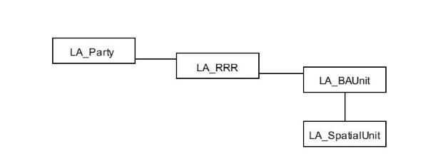
Figure SEQ Figure \* ARABIC 1 – Core classes of
the LADM (ISO, 2012)
Subjects can be legal entities and natural persons; objects are land
parcels defined with a unique identifier (e.g. parcel ID), which is used
to establish connection via rights with subjects who must also have a
unique identifier, such as a personal identification number (PIN). Users
of cadastral system data (subjects) are defined with the class LA_Party,
and they do not have to be stakeholders of land parcels in order to
browse and use the data. For the purposes of identifying users of
cadastral system data as instances of the class LA_Party, it is
necessary to identify their needs but also rights and restrictions for
dissemination of cadastral system data. Identification of users and
their needs, roles and activities can be depicted using UML use case
diagrams or activity diagrams. In this paper, activity diagrams for
standardised and non-standardised cadastral system data dissemination
processes were developed.
4. FORMALISATION OF CADASTRAL SYSTEM DATA USE CASES
Land administration could be defined as management of land tenure,
land valuation, land use and land development (Enemark, Williamson and
Wallace, 2005; Bennett et al., 2012). As cadastral system data is the
core data for land administration, it is expected that it will be
required and employed by other land administration system users. In
order to explore current and future needs for cadastral system data, it
is necessary to formalise the data dissemination processes and define
roles, activities, input and output data, rights, restrictions and
responsibilities of actors in the system.
Generally, the process of using data requires a minimum of two
actors, a provider and a user, as well as a minimum of three activities,
data provision, retrieve and use (Figure 2). In cases of using cadastral
system data, the process cannot be considered in such a simple way.
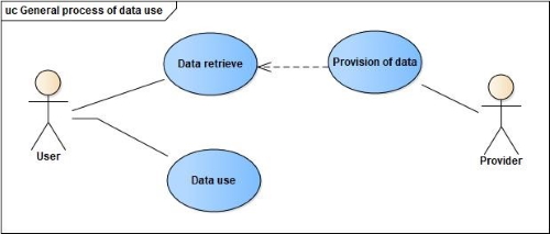
Figure SEQ Figure \* ARABIC 2 – General
methodology for process of using data
The use of cadastral system data is regulated by legislation, meaning
that access to some information may be limited to different users or the
payment of a certain fee is necessary for the required data.
Furthermore, various users will require data in formats that are best
suited for their use intention. Some users may require the data to be
verified, while some may not, and others might require the data to be
provided in real time or at a specific date and time. The aforementioned
requirements could be explored through formalisation of cadastral system
data dissemination processes. The general methodology of process
modelling is of a hierarchical nature. Following a study by van Oosterom
et al. (2019), the authors suggested the below four steps/levels in
process modelling:
- Level 1 – Identification of all the actors/elements involved in
a process according to the specified elements
- Level 2 – Identification of process phases, i.e. groups or
sub-processes relating to a certain topic and provision of generic
descriptions
- Level 3 – Identification of basic activities
- Level 4 – Building of a model
In this paper the focus is on formalising the Level 1 step using
examples of standardised and non-standardised use cases of cadastral
system data and to connect its parts with existing LADM classes. An
example of standardised use case would be the retrieval of cadastral
system excerpts, while an example of non-standardised use case of data
would be data retrieval for the purposes of spatial planning.
4.1 Standardised use of cadastral data
A cadastral system is made up of public registers founded on the
principle of publicity and said registers are obliged to grant access to
registered information to a wide range of users. Thus far, the most
common users of cadastral system data have been citizens and public
authorities. In order to fulfil their requests for data, standardised
excerpts were developed, such as excerpts from cadastral map and
register data or any other cadastral system data unless it is
differently regulated by the legislation.
The first example of cadastral system data use is standardised use
case in terms of requests for excerpts of cadastral map or register
data. This process is demonstrated by means of an activity diagram
(Figure 3).
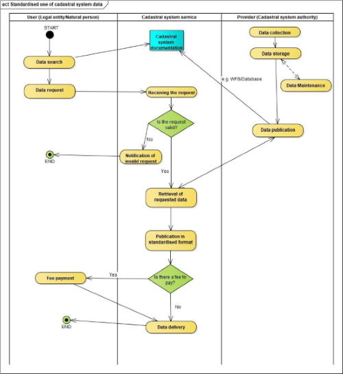
Figure SEQ Figure \* ARABIC 3 – Standardized
use of cadastral system data
In the activity diagram, shown in Figure 3, two main actors are
identified for the process of standardised use of cadastral system data,
namely user (legal entity/natural person) and provider (cadastral system
authority) who communicate through the cadastral system service. Public
entities or natural persons constitute the interested party or initiator
in this process and the role of supervision and execution of the process
is in the domain of the cadastral system service operated by the
cadastral system authority. The input data of this process is generated
by both previously mentioned actors. The data request made by the legal
entity/natural person is submitted after the search for data, which is
enabled by the publication of data by the cadastral system authority
via, e.g., WMS/WFS and database access depending on what type of data is
requested for inspection and retrieval. Output data, the standardised
excerpts or notification of an invalid request, are provided by the
cadastral system service after a series of actions have been completed.
The actions required to fulfil the data request made by the process
initiator are validity check, connection to cadastral publication
system, publication of requested data in standardised format, check for
fee requirement and, finally, delivery of requested data to the process
initiator.
The formalised process indicates the need for development of user
profiles in accordance with legislation because the very first step in
data retrieval is the validity check in terms of whether the initiator
of the process is able to retrieve the requested data. A standardised
format for the output data (excerpts) is also very important, because
the data must be delivered in a form accepted by the process initiator,
e.g. in .pdf format. Data publication should also be in accordance with
the user requirements and it must enable easy access to, and searches
for, cadastral system data.
4.2 Non-standardised use of cadastral data
Modern land administration systems, including cadastral systems, are
expected to support sustainable development in terms of economic, social
and environmental sustainability. The need for cadastral system data has
risen from its original purposes. Many users combine cadastral system
data with their sets of data, which are either derived from cadastral
system data or created in accordance with it. These new user
requirements for cadastral system data can be described as
non-standardised uses of cadastral system data. In this paper, example
of non-standardised use cadastral system data is for the purposes of
spatial planning and it is also formalised by means of an activity
diagram (Figure 4).
Why are these uses of cadastral system data termed non-standardised?
The main reason would be because they transcend the initial purpose of
cadastral systems and affect many other processes which are unrelated to
the cadastral system. A good example of the non-standardised use of
cadastral system data is for the purpose of spatial planning. In order
to reach the multipurpose level of the land administration system, data
interoperability and consistency are critical. A spatial plan is
considered to be very important for cadastral system users, as many
processes concerning land parcels are regulated by the spatial plans and
regulations pertaining to spatial development (e.g. subdivision of land
parcel). In the activity diagram, shown in Figure 4, the process for
access to the use of cadastral system data is described. Access can be
granted via any service such as WFS or database connection.
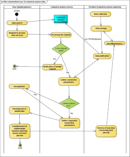
Figure SEQ Figure \* ARABIC 4 –
Non-standardised use of cadastral system data
The formalised process of the non-standardised use of cadastral
system data in this example identifies two actors communicating through
the cadastral system service. The initiator of the process is the
spatial planner who inspects published cadastral system data and then
requests to access the data via the service in order to develop a
spatial plan and to establish relationships between planning blocks and
land parcels registered in the cadastral system. The role of supervision
and execution for the process of accessing cadastral data is in the
domain of the cadastral system authority operating through the cadastral
system service. Input data in this process is generated by both actors,
and is represented by published cadastral system data and generated
requests for accessing the data. Output data, concerning the connection
parameters of the required service, is generated by the cadastral
service after the series of actions have been taken. Actions required to
fulfil the requested access in this process are request validity check,
connection to data publication system, check for fee requirement and,
finally, the delivery of connection parameters to the spatial planner.
The process does not end with the delivery of connection parameters
because after the development of the spatial plan, new set of data
concerning land parcels can be generated and it is represented by
relationships between planning blocks and land parcels, which can later
be delivered to the cadastral system authority in order to update the
current data with new data.
The formalised process of the non-standardised use of cadastral
system data also points out the need for user profile development in
accordance with legislation and user requirements. It is necessary for
the cadastral system to explore a variety of user requirements in terms
of accessing data in order to deliver the data in the most appropriate
format. Since the access to cadastral system data is required by other
public authorities and legal enterprises, in order to develop new land
data which may concern cadastral system data transactions, it would be
possible to develop registered user profiles with user-specific rights
and restrictions for data access.
4.3 Identification of LADM classes with formalised processes
Updates of, and changes to, cadastral system data may concern the
following: parties and their attributes, rights, restrictions and
responsibilities and related attributes, basic administrative units and
related attributes, and spatial units and related attributes. More
generic process-related modules in data acquisition and data handling as
well as maintenance and publication are needed. Process information is
information on who must do what in approving the transaction. The LADM
has already included a series of dates for interaction with the process,
but the current edition of the LADM does not include processes for data
acquisition, maintenance and publication. The connection of existing
LADM classes with formalised processes will be demonstrated on an
example of a standardised cadastral system excerpt for a cadastral
parcel on which is the Faculty of Geodesy at the University of Zagreb,
Croatia located (Figure 5).
In the standardised cadastral system excerpt, shown in Figure 5, it
is possible to establish connections with core classes of the LADM. It
must be noted that the excerpt is provided only in the Croatian
language, and so the parts of the excerpt which relate to the LADM are
marked with red rectangles and numbers next to them. The excerpt was
provided in .pdf format and anyone can request it via the Joint
Information System.
Number 1 in the Figure 5 represents the office in charge of the
maintenance of data shown in the standardised cadastral system excerpt,
which is the Land Register Office for the city of Zagreb, and is under
jurisdiction of the Municipal Civil Court Zagreb. The authority in
charge of the maintenance is denoted by the class LA_Party. Number 2
represents the cadastral municipality where the cadastral parcel is
located, and in this case it is Cadastral Municipality Centre with its
unique identifier. The cadastral municipality is denoted by the class
LA_SpatialGroup. The following number (3) refers to the part of the
excerpt where the information about land parcels and their descriptions
is registered. Number 4 represents the cadastral parcel ID, where the
Faculty of Geodesy is located (2843/4), and it is denoted by the class
LA_BAUnit. Numbers 5 and 6 refer to the description of the cadastral
parcel in terms of land use, address and area and are referred to b the
class LA_SpatialUnit. Proprietorship is noted in the part of the excerpt
represented by the number 7, and the owners of the cadastral parcels
registered in this excerpt are the Faculty of Geodesy, Faculty of
Architecture and Faculty of Civil Engineering which have equal shares of
1/3. The owners are denoted by the class LA_Party. The third part,
marked with the number 9, of the excerpt is reserved for charges such as
mortgages, which are denoted by the class LA_Restriction but in this
example there are no registered charges.
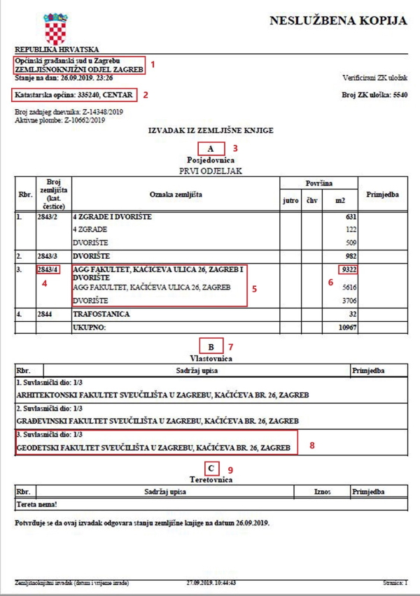
Figure SEQ Figure \* ARABIC 5 – Example of
standardized land register excerpt
Using the abovementioned example, several process elements were
identified in accordance with the LADM, such as output data, format of
data, providing service and authority in charge of maintenance of data.
Further connections between the LADM and process elements were suggested
by van Oosterom et al. (2019) and are as follows:
- Interested party, or initiator of the process, is denoted by the
class LA_Party.
- Executing and supervising party is denoted by the class
LA_Party.
- The input and output data of the process, whether legal
(deed/title) or spatial (map) products, depend on the type of the
process and can be represented by either LA_Source, both spatial and
administrative, but some processes may include special units as
their input/output and hence correspond to LA_SpatialUnit.
- A format or a procedure of data exchange, submission or
distribution required for the process may be depicted by sources’
attributes such as mediaType.
- Restrictions and constraints, which are characteristic in a
given process, may be formed as constraints in the LADM model.
- The legal basis relating to the process may be represented in
the LADM by the LA_AdministrativeSource class
The actions which need to be taken during the process, such as
validity check, data retrieval, fee payment, delivery of data etc. are
not modelled with existing LADM classes. The identification of LADM
classes with the process of non-standardized cadastral data uses
requires more in-depth research and modelling. Detailed analysis of
non-standardised cadastral data uses is planned in the future as an
extension to this paper, and for the further development of the model,
consultations with included stakeholders and users should be conducted.
5. DISCUSSION
It is well known that interoperability, data sharing and data
integration are needed in the development of land administration. Land
administration systems are built around cadastral systems, so the first
step in achieving the abovementioned needs for LAS development is the
identification of user requirements for cadastral system data. User
requirements can be grouped into two main aspects, namely technical and
organisational.
The technical aspect is represented by the process procedure, time,
cost, service, information system and technology. According to Sari
(2010) user requirements in terms of the technical aspect are: need for
one stop shops, need for accelerated/quicker process time, need for
up-to-date, accurate, valid and transparent data and system archive,
need for online registration processes, customer satisfaction and fee
reduction.
Organisational aspect of the user requirements is related to human
resources and regulations supporting the processes of land
administration, while the LADM supports the document exchange in the
electronic environment, therefore some of the processes could be
automated via internet services.
After examination of the two formalised processes in this paper and
the aspects of user requirements, certain questions could be raised in
order to aid in modelling cadastral system data dissemination processes.
Those questions would be:
- Who are the actors in the process?
- What are the actors’ roles in the process?
- Where can the published data be accessed?
- What are the user requirements and are they in accordance with
legislation?
- What are the necessary actions to fulfil user requirements?
- What is the purpose of requested data?
By answering these questions, the main actors, user requirements
(e.g. desired data format) and steps for process automation and control
could be established.
6. CONCLUSION
Meeting user requirements is a growing challenge for all the economy
branches and land administration systems. Cadastral systems, as the core
registers and services in land administration systems, must also respond
to the growing number of user requirements for cadastral system data.
Design and analysis of user requirements, through formalisation and
process modelling, is one way to gain insight into the needs for
cadastral system data in order to provide data in the most suitable
format. Reliability, availability and dissemination of cadastral system
data is crucial for business enterprises and the public sector in order
to produce new sets of data or to upgrade existing data with new
information.
Identification of user requirements for cadastral system data can
lead towards standardisation of user profiles, whose rights,
restrictions and access to data, could be modelled in accordance with
the LADM. From formalised processes of cadastral system data
dissemination, certain steps in developing required data
interoperability, sharing and integrity could be achieved.
In terms of process modelling, as mentioned, the very first step is
the identification of actors and elements of the process. It is
important to stress that the actors and process elements might differ
from country to country because they are subject to enforced laws and
accepted procedures. Because of these differences, it is essential to
formalise processes for country specific cases in order to gain more
in-depth insight into process differences for the purpose of process
modelling and standardisation, which are planned for future development
of generic LADM processes.
Finally, the growing demand for cadastral system data points towards
the need for more explicit process modelling, detailed class diagrams,
and more research in the field of cadastral system data dissemination
processes.
REFERENCES
Arvanitis, A. and Hamilou, E. (2004): Modelling cadastral
transactions in Greece using UML, in Proceedings of the FIG Working, pp.
1–10. , Athens, Greece
Bennett, R., Rajabifard A., Williamson I., and Wallace J. (2012): On
the need for national land administration infrastructures, Land Use
Policy, 29(1), pp. 208–219. doi: 10.1016/j.landusepol.2011.06.008.
Enemark, S. and Williamson, I., Wallace J. (2005): Building modern
land administration systems in developed economies, Spatial Science,
50(2), p. 19
ISO (2012) Geographic Information - Land Administration Domain Model
(LADM) - International standard ISO 19152.
Krigsholm, P., Riekkinen, K. and Stahle, P. (2018): The Changing Uses
of Cadastral Information: A User-Driven Case Study, Land, 7, p. 14.
Lemmen C., van Oosterom, P., Kara, A., Kalogianni, E., Schnaidman,
A., Indrajit, A., Alattas, A. (2019): The scope of LADM revision is
shaping up, in Proceedings of the 8th International FIG workshop on the
Land Administration Domain Model, Kuala Lumpur, Malaysia
Lemmen C., van Oosterom, P., Kalantari, M., Unger, E.M. and De Zeeuw,
C., editors (2019): OGC White Paper on Land Administration, Open
Geospatial Consortium
Lemmen, C., van Oosterom, P., Kalantari, M., Unger, E.M., Teo, C.H.
and De Zeeuw, K. (2017): Further standardisation in land
administration’, in 2017 World Bank Conference on Land and Poverty, p.
22., The World Bank – Washington DC
Lisec, A., Miran, F. and Šumrada, R. (2007): UML Notation for The
Rural Land Transaction Procedure, Geodetski vestnik, 51, p. 12.
Navratil, G. and Frank, A. U. (2004): Processes in a cadastre,
Computers, Environment and Urban Systems, 28(5), pp. 471–486. doi:
10.1016/j.compenvurbsys.2003.11.003.
van Oosterom, P., Kara, A., Kalogianni, E., Shnaidman, A., Indrajit,
A., Alattas, A. and Lemmen, C. (2019): Joint ISO/TC211 and OGC Revision
of LADM: Valuation Information, Spatial Planning Information, SDG Land
Indicators, Refined Survey Model, Links to BIM, Support of LA Processes,
Technical Encodings, and Much More on Their Way!, in Proceedings of the
FIG Working Week, Hanoi, Vietnam
Roić, M. (2012): Upravljanje zemljišnim informacijama Katastar. 1st
edn. Zagreb, Croatia: Sveučilište u Zagrebu Geodetski fakultet.
Sari, K. W. (2010): The Workflow of Maintenance of Cadastral Data as
based on Land Administration Domain Model (LADM) A case study in
Indonesia, Master Thesis, Faculty of Geo-information, Science and Earth
Observation, University of Twente Enschede, Netherlands
Vranić, S. (2018): Modelling transactional workflow management system
over spatial component of cadastral parcels, PhD Thesis, Faculty of
Geodesy, University of Zagreb, Croatia
Vučić, N. and Roić, M. (2014): Complaints in the process of
maintaining the cadastre, Geodetski List, 68, pp. 143-156
Zevenbergen, J., Frank, A. U. and Stubkjær, E. (2007): Real estate
transactions : Procedures, transaction costs and models, IOS Press.
URL1: Joint
Information, accessed 30.09.2019.
BIOGRAPHICAL NOTES
Josip Križanović graduated from the University of
Zagreb, Faculty of Geodesy in 2017 with his diploma thesis Land
Reallocation Based on User Preferences in Land Consolidation. Since
2018, he has been employed at the University of Zagreb, Faculty of
Geodesy as University Assistant on Chair of Spatial Information
Management. He is a PhD student and his main research interests are land
administration systems, modelling of cadastral processes and the LADM.
Miodrag Roić graduated with a degree Geodesy from
the University of Zagreb, Faculty of Geodesy. In 1994. he received a PhD
from the Technical University Vienna. Since 1996, he has been a
professor at the University of Zagreb, Faculty of Geodesy. He was Dean
of the Faculty during the period spanning 2011-2015. The topics in which
he specialises are Cadastre, Land Administration Systems, Engineering
Geodesy and Geoinformatics. He is a corresponding member of the German
Geodetic Commission (DGK) and many other national and international
scientific and professional institutions.
CONTACTS
Josip Križanović
University of Zagreb, Faculty of Geodesy
Kačićeva 26
HR-10000 Zagreb
Croatia
Prof. Miodrag Roić
University of Zagreb, Faculty of Geodesy
Kačićeva 26
HR-10000 Zagreb
Croatia


