Article of the Month -
May 2014
|
The Development of 3D City Model for Putrajaya MPC Database
Chee Hua TENG, Mohd Yunus MOHD YUSOFF and Nur Zurairah
ABDUL HALIM, Malaysia
1) This paper is a Malaysian
Peer Review paper, which will be presented at FIG Congress 2014 16-21
June, in Kuala Lumpur, Malaysia. The leading agency in Malaysia on
Cadastral Survey, the Department of Survey and Mapping Malaysia (JUPEM)
has experienced a need to move from a single purpose cadastre to a
multipurpose cadastre (MPC) environment. A pilot study was
conducted at the Federal Territory (FT) Putrajaya. This paper highlights
the main component of the pilot study which is the FT Putrajaya MPC
database development and basics of 3D city model generated from the 3D
point-cloud data acquired through Mobile Terrestrial Laser Scanning
(MTLS) technology. A general requirement for setting up an MPC database
for Malaysia has been established in this study and it was concluded
that the FT Putrajaya MPC Database and its 3D city model have the
potential as a spatial enablement to the government, private sectors,
and society in general based on the spatial accuracy achieved in this
study.
SUMMARY
As the leading agency in Malaysia on Cadastral
Survey, the Department of Survey and Mapping Malaysia (JUPEM) is
responsible to further modernize the cadastral system in Peninsular
Malaysia. Changes have been made technically, operationally,
structurally and institutionally in Malaysia’s cadastral survey system
from time to time to ensure the Department’s relevancy in serving the
society. The motivations for these changes are mainly due to the
requirement for increased service provision and efficiency, and the
larger needs of clients and governments. As public expectation relating
to land delivery system increases, the need to move from a single
purpose cadastre (its main focus is on the issuance of Titles) to a
multipurpose cadastre (MPC) environment seemed significant to meet the
demands. Thus, in its bid to understand the MPC concept and its
implementation, a pilot study was conducted by the Department under the
10th Malaysian Development Plan at the Federal Territory (FT) Putrajaya.
This paper highlights the main component of the pilot study which is the
FT Putrajaya MPC database development and basics of 3D city model
generated from the 3D point-cloud data acquired through Mobile
Terrestrial Laser Scanning (MTLS) technology. A general requirement for
setting up an MPC database for Malaysia has been established in this
study and it was concluded that the FT Putrajaya MPC Database and its 3D
city model have the potential as a spatial enablement to the government,
private sectors, and society in general based on the spatial accuracy
achieved in this study.
1. INTRODUCTION
As the leading agency in Malaysia on Cadastral
Survey, the Department of Survey and Mapping Malaysia (JUPEM) is
responsible to further modernize the cadastral system in Peninsular
Malaysia. Changes have been made technically, operationally,
structurally and institutionally in Malaysia’s cadastral survey system
from time to time to ensure the Department’s relevancy in serving the
society. The motivations for these changes are mainly due to the
requirement for increased service provision and efficiency, and the
larger needs of clients and governments. As public expectation relating
to land delivery system increases, the need to move from a single
purpose cadastre (its main focus is on the issuance of Titles) to a
multipurpose cadastre (MPC) environment seemed significant to meet the
demands. Thus, in its bid to understand the MPC concept and its
implementation, a pilot study was conducted by the Department under the
10th Malaysian Development Plan at the Federal Territory (FT) Putrajaya.
This paper highlights the main component of the pilot study which is the
FT Putrajaya MPC database development and basics of 3D city model
generated from the 3D point-cloud data acquired through Mobile
Terrestrial Laser Scanning (MTLS) technology.
2. MPC DATABASE SOURCE OF DATA
The MPC database is developed by optimising various
geospatial dataset to create large scale GIS basemaps. Such geospatial
dataset is available within the Department i.e. enhanced FT Putrajaya’s
National Digital Cadastral Database (NDCBD), Strata Database including
scheme footprint (PDUSSM), GIS Layer Management System Database (GLMS),
Large Scale Mapping data, Orthophoto image, LiDAR image, Utility
information and levelling or geodetic features, besides additional data
collected via 3D Mobile Terrestrial Laser Scanning (MTLS) to acquire
Point Cloud Data. Furthermore, State Geospatial Data Center (SGDC)
dataset available at the Malaysian Centre for Geospatial Data
Infrastructure (MaCGDI) for FT Putrajaya area were also acquired and
integrated with the MPC Database. The SGDC dataset consists of various
data categories namely; Built Environment, Transportation, Demarcation,
Topography, Vegetation, Hypsography, Hydrography and Utility.
All geospatial dataset are seamless. The horizontal
components are referenced to GDM2000 (which is the geocentric datum for
Malaysia) while the vertical reference system is based on the National
Geodetic Vertical Datum (NGVD) and complied with the following Malaysian
Standards: Geographic Information/Geomatics – Feature and Attribute
Codes (MS1759); MyGDI Metadata Standard (MMS)- ISO Wizard; National
Geonames Database- PDNG; DSMM Unique Parcel Identifier (UPI) and
administrative code; and DSMM Colour Code and Symbol. The existing and
acquired geospatial datasets were assessed to ascertain the accuracy of
the geospatial data. The assessments are for the following requirements
and criteria:
- Horizontal Accuracy;
Horizontal accuracy was determined using Ground Truth GPS survey at
selected and proven NDCDB boundary mark. Pre-marking of NDCDB
boundary marks were made at selected locations that can be
identified through geoferenced point clouds.
- Vertical Accuracy;
Vertical accuracy was determined using Bench Mark based on National
Geodetic Vertical Datum (NGVD) as validation points. Pre-marking of
bench mark/temporary bench marks were made at selected locations
that can be identified through geoferenced point clouds.
- Geodetic Datum and Coordinate System;
GDM2000 is applied as a reference system for MPC database.
Coordinate transformation from GDM2000 to Cassini and RSO Geocentric
is executed using certified transformation paramater acquired from
JUPEM. Pre determined Cassini Geocentric and RSO Geocentric
Coordinate ground proofing were carried out using GPS survey.
Analysis of the results indicates the quality of the coordinate
system.
- Temporal Accuracy;
Temporal accuracy aims at describing the discrepency between the
actual date of capturing the data and the date as recorded in the
metadata of the dataset. This reflects the currentness of the data.
- Thematic Accuracy;
Thematic accuracy concerns the accuracy of attribute values. The
metrics used to describe thematic accuracy depend on the measurement
scale of the attributes, whether they are measured in nominal scale,
ordinal scale, interval scale or ratio scale.
- Completeness;
Describe the completeness of geographical features over space, time,
theme and scale.
- Consistency;
A dataset is consistent when contradictions are absent. Most
important is topological consistency.
- Level Of Details (LoD) for 3D City Model;
Level of Detail (LoD), is related to how much information is
documented to maintain interactivity of the 3D City model.
2.3. 3D MTLS POINT CLOUD DATA ACQUISITION
Additional 3D geospatial features data collection has
been carried out using Mobile Terrestrial Laser Scanning (MTLS)
technology (see Figure 1). The immediate output of MTLS is 3D point
cloud represented by points in a 3D coordinates system (x,y,h). 3D point
clouds from MTLS produces geospatial information that comprise of
building footprint, road, utility (lamp post, fire hydrant, electrical
post and etc.), lake, tree and other features in scanning window.
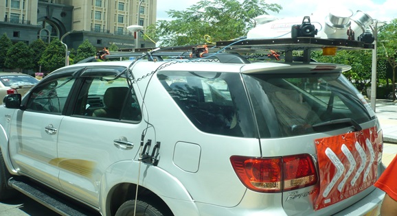
Figure 1: MTLS Dual Laser DynaScan 3 system used
MTLS is an emerging technology that combines the use
of a laser scanner(s), the Global Navigation Satellite Systems (GNSS),
and an Inertial Measurement Unit (IMU) on a terrestrial mobile platform
to produce accurate and precise geospatial data. The data is initially
processed using post-processed kinematic GNSS procedures. The GNSS
solution is then combined with the IMU information to produce geospatial
data in the form of a point cloud. This point cloud is then adjusted to
well defined points throughout the project area to produce the final
geospatial values.
The MTLS data at 95% confidence level (1s) is good to +- 5 cm for the
horizontal and +- 7cm for vertical.
2.4. MTLS DATA ACQUISITION METHODOLOGY
The adopted methdology for MTLS data acquisition is shown in Figure
2. The methdology comprises of the following 5 phases of activities: i)
Project Preparation; ii) Mission Planning; iii) Field Survey Planning;
iv) Processing of Point Clouds; and v) Processed 3D Point Clouds.
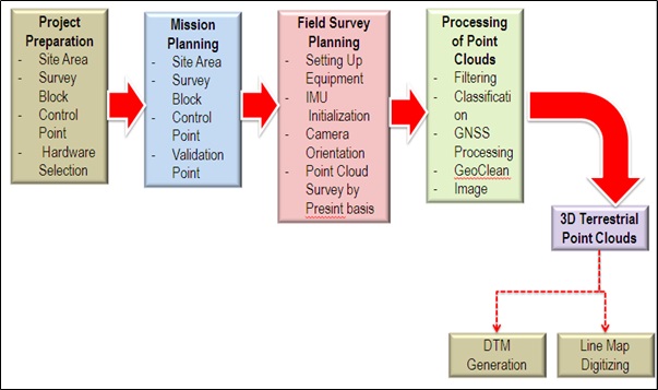
Figure 2: Adopted Methodology for MTLS Data Collection
A Geodetic Datum Transformation System (MTRANS)
Version 4.1 software has been used to transform all the point clouds to
GDM2000 datum reference system and projected to Cassini GDM2000.
Vertical reference system was based on National Geodetic Vertical Datum
(NGVD) and the vertical components is derived by reducing the
ellipsoidal height to Mean Sea Level (MSL) height using MyGeoid and
local levelling bench marks.
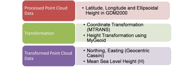
Figure 3: Coordinate Transformation and Elevation Workflow for Point
Clouds

Figure 4: Detailed Coordinate Transformation and Elevation Workflow for
Point Clouds
For future usage, raw data in the Mobile Terrestial
Laser Scanner is kept in universal WGS84 format. The data is exported to
NEH format (.pts) via QINsY data export. The file is then converted to a
personal geodatabase (.mdb) via Microsoft Access. This format is later
converted to shape file. Multiple shapefile is then imported into
geodatabase (.gdb). The final step is to convert the coordinate system
to GDM2000 Coordinate System via the MPC Application Module.
The adopted processing methdology for the collected
MPC MTLS data is shown in Figure 5.
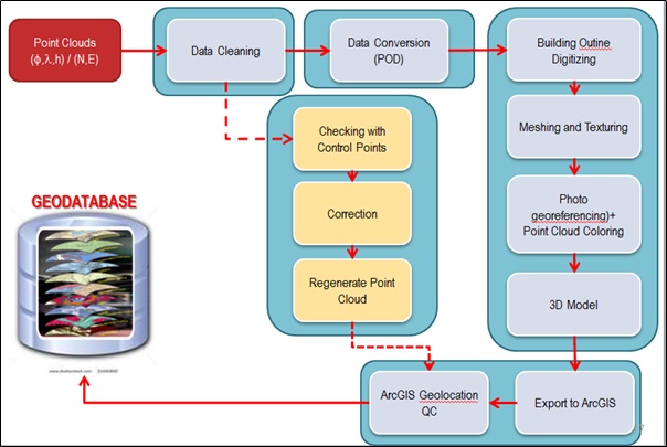
Figure 5: MTLS data processing methodology
In the data processing methodology, the point cloud
obtained from the MTLS is appropriately cleaned. Noise and spikes from
the laser scanning is removed using either Qloud or Pointools. The
cleaned data is then converted to POD format. With Trimble Sketchup, the
POD file is then used to digitize the building outline. This is followed
by meshing and texturing the wire frame. Photos are georeferenced and
point cloud coloured. 3D models will then be digitized using Trimble
Sketchup. The amount of details digitized will depend on requirement.
The models produced will then be exported to ArcGIS. The cleaned data is
also checked and compared to Control Points. Corrections will be applied
if error is minor. Data will be recollected if error is large. Point
cloud will be regenerated with applied correction. ArcGIS Geolocation
and Quality Control is then done on the 3D Model and Point Cloud. This
is imported into the MPC geodatabase.
Due to the MTLS limitation, the top part of the
buildings in FT Putrajaya were not scanned. Hence additional data
provided by LiDAR and high resolution satellite images were utilized to
fill-up the gaps (roof top images) in the 3D City modelling.
3. MPC DATA CONVERSION, ENTRY, MIGRATION AND INTEGRATION
All the geospatial dataset acquired in this study
were processed using the MPC Application Module which has been developed
to enable integration of multiple data sources, validation of MPC
database and updating new spatial features. The main objective of the
module is to produce seamless geospatial data. The module has three (3)
main tasks, i.e., Data Conversion, Data Entry and Data Migration. It is
developed based on a desktop-based GIS development environment to extend
GIS functionality, customize and automate repetitive operations, and
integrate ArcGIS version 10 with VBA functionality. The Data Conversion,
Data Entry and Data Migration process is described in Figure 6. The
integration of geospatial dataset and enhanced NDCDB can be divided into
4 main phases as visualize in Figure 7.
4. INTEGRATION WITH STREET ADDRESSES DATABASE FOR FT PUTRAJAYA
Another component highlighted under the MPC
Application module is Integration with street addresses. Street
addressing is to assign an address using a system of maps and signs that
give the numbers or names of streets and buildings. Geocoding of Street
Address database is based on the enhanced NDCDB and building feature
acquire during data acqusition process. Enhanced NDCDB consists of
cadastral lot information, UPI and newly created Object Identification
(OID). OID is created for building feature. Based on the street address
database, geocoding process has been conducted systematically using
cadastral lot number, UPI and OID. These information can be linked to
zip, postal or situs method to generate street addreses based on
integrated MPC GIS base map.
Geocoding is the process of finding associated
geographic coordinates (often expressed as latitude and longitude) from
other geographic data, such as street addresses, or zip codes(postal
codes). Geocoding is an important tool when it comes to geographic data
accuracy. In order to geocode data, it must contain information about
location such as a street address, a postal code (or at least part of
it), or a name of an area, e.g.county, census subdivision, etc.
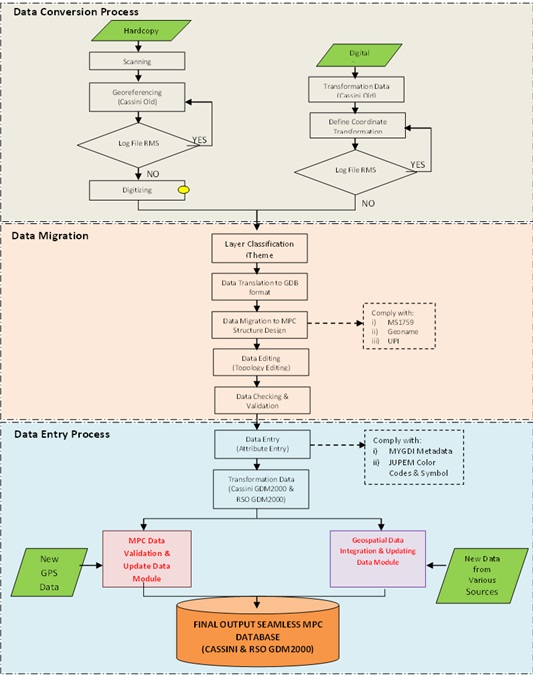
Figure 6: Conceptual of Integration Methodology
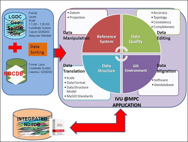
Figure 7: Data Integration Process
Three main steps of geocoding were established as follows:
- Geocoding by street addresses
Relationship Between Building and Street Address Using UPI and OID
- Geocoding by postal codes
Relationship Between Building and Street Address
- Geocoding by boundary
Relationship Between Building Information With Respect To Cadastral
Lot
Relationship between building and Lot using UPI and OID
Relationship between road and Street Address using UPI and OID
5. GEOSPATIAL DATASET PROCESSING
The MPC geospatial datasets acquired from the Department and MaCGDI
are processed with the following criterias:
- All data collected/acquired are carried out with data fusion to
achieve inference and employ the following technique:
- Model Builder;
- Analytical Hierarchy Process; and
- Thematic analysis.
- Satellite images are ortho-rectified with high level of
positional accuracy and to remove any vertical distortion effect;
- Registration procedure between LiDAR and satellite image;
- Final vertical height system for LiDAR data is NGVD;
- The vertical component-height is based on MLTS dataset;
- Line map are topological and geometrical corrected;
- Spatial features such as buildings, and other objects like
traffic network, water bodies, terrain, vegetation and open area
shall be extracted;
- The generation of Digital Terrain Model follows the following
method:
- Generating the TIN using Delaunay triangulation;
- Interpolation of MLTS dataset are based on best practice
methodology;
- 1 square meter spatial resolution grid; and
- Classification between ground points and above ground
points.
- Transformation approach is based on point to point map object
transformation approach for multiple features;
- All transformation employed the certified coordinate
transformation parameters endorsed by the Department;
- Data checking procedures are carried out for feature class and
feature dataset with appropriate topology rules;
- Unique feature identification are generated using coordinate
domain method; and
- Feature class and feature dataset are carried out with overlay
test.
6. GENERATING 3D CITY MODEL
The FT Putrajaya MPC 3D City model has been generated
from the MTLS and GIS Base Map data categories. Attribute entry has been
carried out based on the availability of information obtained from the
MTLS scanning. Data fusion from multiple geospatial datasets contains
attributes information enriched the 3D city model for W.P Putrajaya. 3D
City models may be created at five levels of detail (LoD):
- LoD0: a DEM with superimposed ortho-rectified aerial or
satellite imagery;
- LoD1: basic block-shaped depictions of buildings are placed over
LoD0;
- LoD2: LoD2 adds to LoD1 detailed roof shapes;
- LoD3: represent further expansion by adding to LoD2 structural
elements of greater detail, such as facades and pillars, and draping
all objects with photo texture; and
- LoD4: the highest level, is achieved when building can be
virtually visited and viewed from the inside.
For this study, Level of Details 2 (LoD2) were used
to depict 3D building in the housing estates in Putrajaya. Buildings in
Precinct 14 Putrajaya housing estate, for example, were digitized
conforming to LoD2 requirement. Level of Detail 3 (LoD3) were used to
depict government buildings along the main boulevard in Putrajaya while
LoD4 has been developed for the Putrajaya Central.
The 3D City Model for FT Putrajaya was produced
manually using Trimble Sketchup and then exported to ArcGIS Map. This
was then integrated to database and set as a globe project in ArcGIS
Server. This project could be recalled via a client PC through ArcGIS
Explorer Desktop.
The 3D City model visualization for FT Putrajaya
integrates image textures for the rendering process. This process
generates virtual reality of the real world. Sketch Up and ArcGIS
Desktop Explorer software has been used to drape the related image to 3D
city model. They were also subsequently used for Virtual Reality
rendering and visualization of the 3D City model. The accuracy of 3D
object depends on the 3D Terrestrial Point Clouds which is between 5cm
to 2m.
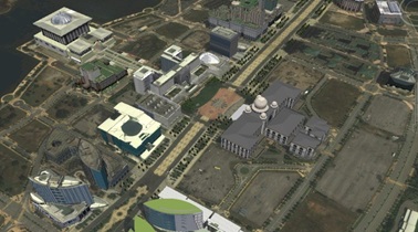
Figure 8: 3D Model FT Putrajaya
7. SEAMLESS MPC DATABASE
Validation of a seamless MPC database follows the validation workflow
shown in Figure 9. Validation workflow consists of the following:
- Entity-Attribute Agreement: Matching of spatial feature and
attribute with real world;
- Overlay Testing: Identifying intersection and gap between
features; and
- Spatial Accuracy: pre marking NDCDB boundary mark
Data quality indicators for geospatial data are based on the
following:
- Accuracy—positional;
- Accuracy—attribute;
- Completeness;
- Logical consistency; and
- Lineage.
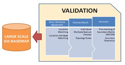
Figure 9: Validation Workflow Process
As for the 3D City Model, an Overlay Test were conducted on the
orthophoto and fits nicely on the building foorprint and the Cadastral
lots as shown in Figure 10.
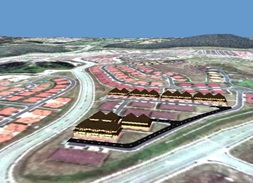
Figure 10: 3D Buildings and Footprint Overlay Test
8. MPC DATABASE SPATIAL ACCURACY
In order to conform with 95 % confidence level (1s),
30 verification points (Figure 11) must comply with the specified
accuracy tolerance. The verification point has been focussed to MPC
Database that include all related dataset such as line map extracted
from 3D Terrrestrial Point Cloud, enhanced NDCDB, LGDC Putrajaya,
Utility and other related datasets.
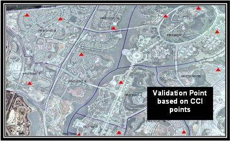
Figure 11: Validation Points for MPC Database
Planimetric coordinate and Vertical Height comparison
were carried out using predetermined NDCDB boundary marks at 30
distributed locations/ features in FT Putrajaya MPC Database. The
accuracy for MPC Database obtained are:
- Enhanced NDCDB is +- 5cm ( Horizontal) at 1s;
- Point Clouds from MTLS: Sigma ±16 cm ( Horizontal) depending on
satellite condition at 1s;
- Point Clouds Vertical Accuracy from MTLS base on NGDV 1 Sigma
±40 cm: 1s;
- Geospatial Features from Orthophoto (over MTLS) : N=±2.48m,
E=±5.85m; and
- 3D City Model Spatial Accuracy is +- 18cm
The accuracy achieved are acceptable and the MPC database developed
can be optimised for planning purposes and other Cadastral Survey
services purposes.
9. CONCLUSION
Based on the study conducted, it was agreed the
following requirements are crucial in setting up a seamless and
homogenous MPC database for Malaysia which are; Enhanced NDCDB as a
base-map (shall be used as a reference layer in MPC database topology
checking and validation); Comply with the Malaysian Standard for Feature
and Attribute Coding Catalogue (MS1759); based on the SGDC theme layers;
coordinate transformation are based on parameters endorsed by JUPEM; and
objects to be model for 3D City model shall be at least on prominent
buildings or landmark. It was concluded that the FT Putrajaya MPC
Database and its 3D city model have the potential to support spatially
enable government, private sectors, and society in general, and to
expand computer support in the process of visualization, organization
and management of useful land information considering the high spatial
accuracy achieved in this study. The accuracy of 3D MTLS features in the
FT Putrajaya MPC Database can also be further improved with the use of a
more sophisticated MTLS system.
REFERENCES
Discovering Possibilities of Implementing Multipurpose Cadastre in
Malaysia - Hasan JAMIL, Mohd Yunus MOHD YUSOF, Nur Zurairah ABDUL HALIM,
Malaysia; FIG Working Week 2013 - Enivironment for Sustainability; May
2013; Abuja, Nigeria
Department of Survey & Mapping Malaysia – Final Report on MPC Pilot
Project for FT Putrajaya; January 2013
Department of Survey & Mapping Malaysia - Kontrak T8/2011: PEROLEHAN
PERKHIDMATAN MEMPERKASAKAN PANGKALAN DATA UKUR KADASTER DIGITAL
KEBANGSAAN (NDCDB); July 2011
BIOGRAPHICAL NOTES
TENG Chee Hua is a Director of Cadastre Division at Department
of Survey and Mapping Malaysia (JUPEM). He has been working with JUPEM
in various capacities since 1980 and has interest and experience in
cadastre, photogrammetry, geodesy and digital image processing. He is a
fellow of Royal Institution of Surveyors Malaysia.
Mohd Yunus MOHD YUSOFF is a Director of Licensed Surveyors
Inspectorate Section at Department of Survey and Mapping Malaysia
(JUPEM). He has been working with JUPEM in various capacities since
1985. He majors in GNSS and space geodesy. He is currently the elected
Vice President of Malaysia Professional Centre and a member of Royal
Institution of Surveyors Malaysia.
Nur Zurairah ABDUL HALIM is an Assistant Director of Survey of
Cadastral Division at Department of Survey and Mapping Malaysia (JUPEM).
She is one of the Core Group that is responsible with most of Cadastral
projects development, namely the eKadaster project and MPC pilot
project, and has more than 10 years experience in handling project
coordination and policies related to Cadastral Survey activities.
CONTACTS
Teng Chee Hua
Department of Survey and Mapping Malaysia
Level 10, Wisma JUPEM
Jalan Semarak
50578
Kuala Lumpur
Malaysia
Tel. +60326170615
Fax + 60326170681
Email:
tengcheehua@jupem.gov.my
Web site: www.jupem.gov.my
 |