Article of the Month - April 2021
|
Innovative Tools and Strategies to Conciliate
Floodplain Restoration Projects and Spatial Planning in France: the
“Over-Flooding Easement
Marie Fournier, Adèle Debray And Mathieu Bonnefond,
France
 |
 |
| Marie Fournier |
Mathieu Bonnefond |
This article in .pdf-format
(11 pages)
This paper is mainly based on the results of the FARMaine project.
The authors analyzes the consequences of environmental public
policies on agricultural land and practices in the Maine river basin
(Région Pays de la Loire).
SUMMARY
In France, flood management policies have strongly evolved since the
1990s. Flood mitigation has become a key strategy in order to contribute
to the diversification and sustainability of flood risk management
policies (Larrue et al., 2015).
In this context, more and more river authorities launch and implement
floodplain restoration and water retention projects locally in France.
Like in most Western European countries, it is now taken for granted
that flood management requires ‘‘making space’’ for water by increasing
retention capacity of floodplains (Warner et al., 2012). However, in
many European countries, floodplain restoration still proves to be a
societal challenge (Moss, Monstadt, 2008) and rural land has an
important role to play in flood mitigation (Morris et al., 2010).
In this context, our presentation focuses on a specific legal
mechanism – the over-flooding easement (“servitude de sur-inondation”) –
created in France in 2003 in order to facilitate the implementation of
floodplain restoration and water retention projects. Our research shows
that more and more river and flood management institutions choose to use
this public utility easement in order to control land uses and
activities in the floodplains and avoid land acquisition. However, this
legal tool may have important consequences for land uses and economic
activities. We use the case of the Oudon river basin (Western France,
(Mayenne/Maine-et-Loire)) and describe how river managers have
succeeded, via local agreements, in building synergies between their own
objectives (the restoration of floodplains and water retention areas)
and farming activities impacted by the over-flooding easement.
1. INTRODUCTION
In France, flood risk management (FRM) policies have strongly evolved
since the 1990s. Flood mitigation has become a key strategy in order to
contribute to their diversification and sustainability (Larrue et al.,
2015). Flood mitigation measures aim at reducing the likelihood and
magnitude of flooding; they are complementary to flood defense. They are
being put in place through actions that accommodate (rather than resist)
water, such as natural flood management or adapted housing (Fournier et
al., 2016). Within this strategy, more and more river authorities, i.e.
river syndicates or inter-municipalities competent for FRM, launch and
implement floodplain restoration and water retention projects in France.
Like in most Western European countries, it is now taken for granted
that flood management requires ‘‘making space’’ for water by increasing
the retention capacity of floodplains (Warner et al., 2012). However, in
many European countries, floodplain restoration still proves to be a
societal challenge (Moss, Monstadt, 2008) and rural land has an
important role to play in flood mitigation (Morris et al., 2010).
In this context, our presentation focuses on a specific legal
mechanism – the over-flooding easement (“servitude de sur-inondation”) –
created in France in 2003 in order to facilitate the implementation of
floodplain restoration and water retention projects. The over-flooding
easement was created in order to contribute to floodplain storage and
conveyance projects (identified as “making space for water” projects by
Morris et al., 2016). Thanks to this public utility easement, river
authorities can delineate and fix specific rules in water retention
areas which have been equipped with hydraulic works. Our research shows
that more and more river authorities choose to use this easement in
order to control land use in the floodplain and avoid land acquisition.
However, this legal tool may have important consequences for local land
users and economic activities. As a result, negotiation processes are
often launched in order to conciliate FRM objectives and other/former
land uses.
This presentation is mainly based on the results of the FARMaine
project (“Pour et Sur le Développement Régional” (PSDR4 Grand Ouest
2016-2020) Research Programme (www.psdrgo.org)).
This project analyzes the consequences of environmental public policies
on agricultural land and practices in the Maine river basin (Région Pays
de la Loire). In this presentation, we mainly use the results coming
from scientific and grey literature review, semi-structured interviews
with institutional local stakeholders on the Oudon river basin and
participant observation.
First we describe the national context in which the over-flooding
easement has become a key procedure for local authorities in their
projects to mitigate the flood risk. Then, we explain more in detail the
legal mechanisms for this new public utility easement. In particular, we
point out its advantages and limits for river managers. Eventually, we
use the example of the Oudon river basin and focus on the negotiation
processes and agreements which have been necessary for local authorities
and private stakeholders to build synergies between FRM policies and the
local economic activities impacted by the over-flooding easement.
2. A LEGAL INSTRUMENT AT THE DISPOSAL OF FRENCH LOCAL AUTHORITIES TO
FACILITATE THE IMPLEMENTATION OF MITIGATION PROJECTS
If the over-flooding easement was introduced in the French law about
20 years ago, it took some years before French local authorities start
to use this legal instrument. Empirical research (Broussard, 2019) shows
that more and more French local authorities competent for flood and
river management have preferred this instrument to others (such as land
acquisition) during the last five years. In order to understand its
increasing use, it is important to recall that it has been concomitant
to two major evolutions in French FRM policies.
First, it is only since a decade or so that local authorities play an
increasing role and involvement in FRM policies in France. While FRM
used to be mainly dominated by the French central government
administration, new competences have been transferred to them by law
during the last years. In particular, the MAPTAM law (2014) conferred
them a new responsibility for water management and flood prevention
(so-called GEMAPI competence (GEstion des Milieux Aquatiques et
Prévention des Inondations)). This new competence was created in order
to facilitate the integrated management of water and floods issues at
local level. Within the MAPTAM Act, municipalities are clearly
identified as the key stakeholder in flood risk management. They hold an
exclusive and mandatory competence in this field. Even though they were
already responsible by law for water production and delivery, the MAPTAM
Act defines several new competences for them:
- River basin management;
- Maintenance and works on rivers, canals, lakes;
- Defense against floods and sea;
Protection and restoration of rivers and wetlands.
In practice, it is mainly via inter-municipal organizations (river
syndicates or intercommunalities) that French local authorities launch
flood mitigation projects to better deal with natural hazards (Fournier,
2019)
In this context, French local authorities are progressively investing
the mitigation strategy within FRM policies. Among all FRM strategies
(defense, preparation, recovery, prevention and mitigation as defined by
Hegger et al., 2016), preparation, recovery and defense still remain
strongly dominated by the French central government, but the mitigation
strategy has been more and more invested by local authorities within the
last decade. Indeed, it has become an opportunity for them to challenge
and face the prevention rules imposed by central government in the Plans
for Flood Risk Prevention (Plans de Prévention des Risques inondation
(PPRi)), often considered as being too restrictive (Fournier et al.,
2016). Since a decade or so, French municipalities or intercommunalities
have started to launch mitigation projects addressing both hazard or
vulnerability issues. Measures at property level (flood resilient
housing) but also measures to better deal with natural hazards (flood
storage areas such as presented in Figure 1, sustainable urban drainage,
wetland creation or the restoration or river corridors) have been
launched. Financial incentives were also created by the central
government in order to promote mitigation projects at local level.
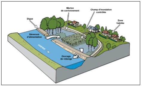
Figure 1 : schematic diagram of a flood
storage area
(source: Isère River Syndicate (symBHI))
To conclude, in a context of climate change and growing uncertainties
about natural hazards, French local authorities are entitled to define
new ways to deal with the flood risk. In this context, the over-flooding
easement has become more frequently used in the implementation of
mitigation projects dealing with the flood hazard. For French local
authorities, this easement constitutes an opportunity, with limited
financial investments, to improve local resiliency. As described in the
following section, without any land acquisition, the over-flooding
easement is implemented in order to control activities (and mainly
farming) in flood retention areas.
3. A LEGAL INSTRUMENT TO BETTER CONCILIATE FLOOD MITIGATION
OBJECTIVES AND CURRENT LAND USES
In this section, we describe more precisely the mechanisms of this
legal instrument. We also point out its advantages and limits for local
authorities.
As stated previously, the over-flooding public utility easement was
created in 2003 with two other public utility easements (creation or
restoration of mobility areas in the riverbed and protection or
restoration of strategic wetlands). They are defined in article L.211-12
article in the French Environment Code.
This legal procedure was designed in order to facilitate the protection
of temporary water storage areas. It is important to point out that the
“over-flooding” easement can only be implemented in an area where the
retention capacity has been increased by hydraulic works (via the
construction of dams, dikes and so on). Therefore, the objective is to
increase flooding and store water in the upper part of a riverain basin,
in order to reduce floods and water run-off downstream and in urban
areas.
Such projects may have important direct and indirect impacts on
agricultural/farming land (increase of the water level and duration of
submersion, extension of the flood prone area and so on… (Ministère de
l’Agriculture et de l’Alimentation/Ministère de la Transition Ecologique
et Solidaire, 2018)).
Both central government administration and local public authorities
may be at the initiative of this procedure but empirical research shows
that this is mainly done by the latter (Broussard, 2019). The
enforcement of this easement is quite complicated. First, a public
inquiry must be conducted locally. The project is described and
justified. A map of the area and the list of landowners must be settled.
Complementary inquiries may be needed if hydraulic facilities are
planned to increase water retention. Then, a decree taken by the local
representative of the central government, the prefect (Préfet),
identifies the perimeter and parcels concerned by the easement.
There are various consequences for landowners and tenants. The decree
may impose a preliminary declaration for any new hydraulic project that
could reduce or limit water retention in the future. Landowners and
tenants must also give permanent access to their land for the public
agents in charge of the maintenance of the water retention area. If the
central government administration or local authorities own and rent
agricultural land in the perimeter, they can impose binding clauses to
the tenants in order to prevent damages when leases are renewed. Some
compensations were created by the 2003 “Risks” Law. First, financial
compensations are paid by the procedure holder to landowners, when
prejudices are direct and certain. Tenants (mainly farmers) may also
receive financial compensations in case of damage on buildings (but not
always for crops or livestock losses). Landowners may also impose the
acquisition of their land by the procedure holder (“droit de
délaissement”). In 2003, the “Risks” Law also gave the possibility for
local authorities to use their pre-emptive right to buy land in the
perimeter of the easement (Struillou, 2012).
In a nutshell, river restoration and flood mitigation projects have
often proved to be conflictual along rivers in France and their holders
must define specific strategies to control land uses (Bonnefond et al.,
2017). This new procedure is an opportunity for local authorities to
avoid drastic land tenure measures, such as land acquisition, as it used
to be more common a decade ago (Bonnefond, Fournier, 2013). Costs and
negotiation processes are limited (as there is no acquisition), former
land uses can be maintained but they are controlled. However, it is also
important to point out some limits. Such projects often lead to an
increase of the flooded area locally, a decrease of the land value and
the necessity for their holders to organize discussions with landowners
and tenants about financial or material compensations. At last, it is
important to recall that such easement is permanent. It implies that any
future purchaser of the land must adhere to the easement.
Therefore, even though the over-flooding easement presents less
constraints than other legal instruments for the institutional holders,
in practice, it still implies discussion and negotiation between all
stakeholders involved locally and must be often combined with other
instruments. In the last section, we illustrate with a case study (on
the Oudon river basin) and describe how negotiation and arrangements
with local farmers have been necessary to successfully implement this
procedure.
4. A LEGAL INSTRUMENT CONFORTED BY LOCAL NEGOTIATIONS AND
ARRANGEMENTS: THE EXAMPLE OF THE OVER-FLOODING EASEMENTS ON THE OUDON
RIVER BASIN
As we can see in Figure 2, the Oudon river basin is located in the
Western part of France (Maine-et-Loire/Mayenne Departments). The Oudon
river basin is mainly rural and dominated by farming activities.
Extensive grazing still remains in the bottom valleys but crop
production is increasing. Figure 3 gives an overview of typical
landscape in the Oudon bottom valleys.
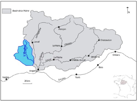
Figure 2: The Oudon river basin, in the
Western part of France
(credits: M. Bonnefond, 2018)
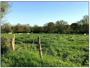
Figure 3: Meadows in the Oudon bottom
valleys/Segré en Anjou
(credits: A. Debray, 2018)
In France, local authorities and river syndicate on the Oudon river
basin were pilot in the implementation of this new type of public
utility easement. In the beginning of the 2000s, after several major
floods and major damages on hundreds of houses, they decided to create
flood storage areas; in their project, they quickly faced the land
tenure issue. Two options were considered: land acquisition or the
implementation of a new procedure, the over-flooding easement. As
explained during our interviews, local authorities decided to choose the
latter, in order to avoid/limit conflicts with farmers.
Several perimeters were settled in the southern part of the river
basin for the enforcement of the over-flooding easement first. Since
then, 12 perimeters have been delineated in total (the largest perimeter
is about 45 hectares). Locations were identified by the river syndicate
in cooperation with central government administrations and the Chambers
of Agriculture at local level (Maine-et-Loire and Mayenne Départements).
The river syndicate bought the parcels where hydraulic works had to be
built and the perimeters of the over-flooding easement delineated the
flood-prone areas.
Financial compensation, for both land owners and tenants, quickly
became a key issue. If the the river syndicate first considered the
parcels of little value, the Chambers of Agriculture battled to increase
compensations. In 2003, a first “agreement for compensation of land
owners and tenants” was signed, even before the enforcement of the
over-flooding easements. A 10% offset based on the land value was paid
to owners and financial compensations were also planned for tenants in
case of damages on crops, livestock and material goods (Debray et al.,
2019).
It is important to point out that local farmers also had the
opportunity to participate in the negotiation process. Since then, the
Oudon river syndicate forecasts about 20 000 euros every year to
compensate farmers.
The Oudon river syndicate had to face several difficulties and
oppositions, even though the Chambers of Agriculture were partners and
involved in the choice and design of this strategy; some perimeters were
abandoned because of local oppositions. The farmers, fearing the
economic and sanitary impacts of repeated floodings, as well as the
constraints on land farming, regularly contested the projects during
public meetings or meetings with the syndicate. If the Oudon river basin
was an early and pilot project, some authors describe similar issues on
other French river basins. On the Brévenne and Turdine river basin,
Riegel (2018) describes very finely how compensations have been
negotiated and calculated in agreement between the river syndicate
holding the project for the local authorities and professional
organizations defending the farmers’ interests. In particular, she
explains that indemnities have been calculated differently for each
farmer, taking into account the specific situation of each of them.
5. DISCUSSION
To conclude, the over-flooding public utility easement has
progressively become an important legal instrument for French local
authorities in the implementation of their mitigation projects dealing
with the flood hazard. In the years to come, the over-flooding of rural
and agricultural land may become more common in France to better protect
urban areas downstream. In this presentation, we pointed out the
advantages and limits of this procedure, which remains quite new and
still under experiment in many river basins. Local authorities tend to
avoid land acquisition and choose this procedure, which has permanent
legal consequences on land rights though. From our empirical
investigation, it appears that local negotiations constitute a key step
in its implementation and in the delimitation of perimeters. These steps
cannot be avoided by the institutional authorities in charge of such
projects. Unlike stated at the premises of the years 2010 by some
authors, landowners and tenants are far from being passive in its
proceedings and do not only bear the consequences of the easement
(Moliner-Dubost, 2013). They are consulted during the public inquiry and
most of all their involvement is crucial in the definition of the
perimeter and conditions of implementation (compensations, constraints
on land uses) of the easement. Empirical investigation shows that local
authorities often prefer to abandon projects if they do not reach an
agreement locally. Beyond the legal dimension of such procedure,
institutional holders must legitimate the flooding of rural land in the
benefits of cities and integrate the local socio-economic issues at
stake.
REFERENCES
Bonnefond, M., Fournier, M., Servain, S., Gralepois, M., 2017, « La
transaction foncière comme mode de régulation en matière de protection
contre les inondations. Analyse à partir de deux zones d’expansions de
crue : l’Île Saint Aubin (Angers) et le déversoir de la Bouillie (Blois)
», Revue Risques Urbains / Urban Risks, Vol 17- 2, ISTE Editions.
Bonnefond M., Fournier M., 2013, « Maîtrise foncière dans les espaces
ruraux. Un défi pour les projets de renaturation des cours d’eau »,
Economie rurale, n°334, p. 55-68.
Broussard, F., 2019, Préservation et gestion de la
multifonctionnalité dans les Zones d'Expansion de Crues : le cas du
bassin de la Maine, Mémoire de fin d’études, École Supérieure des
Géomètres et Topographes (Le Mans).
Debray, A., Fournier, M., Bonnefond, M., 2019, “Quels outils pour
concilier au mieux agriculture et gestion du risque d’inondation ? Mise
en oeuvre et effets de la servitude de sur-inondation sur les pratiques
agricoles dans les fonds de vallée”, 13èmes Journées de la Recherche en
Sciences Sociales, Société Française d’Economie Rurale, Bordeaux, 11-13
December 2019.
Fournier, M., 2019, “Flood Governance in France. From Hegemony to
Diversity in the French Flood‐Risk Management Actors' Network”, in
Lajeunesse, I., Larrue, C., Facing hydrometeorological extreme events: a
governance issue, Wiley.
Fournier, M., Larrue, C., Alexander, M., Hegger, D.L. T., Bakker,
M.H.N., Pettersson, M., Crabbé, A., Mees, H., Chorynski, A., 2016,
“Flood risk mitigation in Europe: how far away are we from the aspired
forms of adaptive governance?”, Ecology and Society, 21(4):49.
https://doi.org/10.5751/ES-08991-210449
Hegger, D. L. T., Driessen, P.P.J., Wiering M., Van Rijswick
H.F.M.W., Kundzewicz Z.W., Matczak P., Crabbé A., Raadgever G.T., Bakker
M. H. N., Priest S. J., Larrue C., and Ek K, 2016, “Toward more flood
resilience: is a diversification of Flood Risk Management strategies the
way forward?” Ecology and Society, 21(4):52.
https://doi.org/10.5751/ES-08854-210452
Larrue C., Bruzzone S., Lévy L., Gralepois M., Schellenberger T.,
Trémorin J-B., Fournier M., Manson C., Thuilier T., 2015, Analysing and
evaluating flood risk governance in France. From state policy to local
strategies, STAR-FLOOD (FP7/2007-2013).
Ministère de l’Agriculture et de l’Alimentation/Ministère de la
Transition Ecologique et Solidaire, 2018, Prise en compte de l’activité
agricole et des espaces naturels dans le cadre de la gestion des risques
d’inondation: guide destine aux acteurs locaux. Volet activité agricole
– version 2, 124p.
Moliner-Dubost, M., 2013, “Le destinataire des politiques
environnementales”, Revue Française de Droit Administratif, p. 505 et s.
Morris, J., Hess, T.M., Posthumus, H., Agriculture’s role in flood
adaptation and mitigation – policy issues and approaches, Sustainable
Management of Water Resources in Agriculture, OECD, Paris.
Morris, J., Beedell, J., Hess, T.M., 2016, “Mobilising flood risk
management services from rural land: principles and practice”, Journal
of Flood Risk Management, volume 9, p. 50-68.
Moss, T. Monstadt, J., 2008, Restoring Floodplains in Europe: Policy
contexts and project experiences, IWA Publishing.
Riegel, J., 2018, « Le dialogue territorial au risque de l’écologie?
Traces et effets d’une concertation entre aménagements hydrauliques et
restauration écologique », Participations, N° 20, 1, p. 173-198.
Struillou, J.-F., 2012, “Droit de preemption et prevention des
risques”, Actualité Juridique Droit Administratif, p. 1329 et s.
Warner, J., Edelenbos, J., Van Buuren, A., 2012, Making space for the
river: governance challenges. Making Space for the River. Governance
Experiences with Multifunctional River Flood Management in the US and
Europe, IWA Publishing.
BIOGRAPHICAL NOTES
Dr Marie Fournier is Assistant Professor in Urban and Land Planning
at the National Conservatory of Arts and Crafts (Conservatoire National
des Arts et Métiers- CNAM). In 2010, her PhD focused on public
participation in flood risk management policies. She is scientific
coordinator of the FARMaine research project (financed by the research
programme "On and For Regional Development" : www.psdr.fr). She is
involved in research projects which analyse the implementation of river
and wetland management policies in France. She has a specific focus on
local governance and the involvement of private stakeholders in public
policies. In her research, she is also interested in the design and
implementation of public instruments, local arrangements and their
consequences on land uses and land use rights.
Dr Adèle Debray holds a PhD in Urban and Land Planning (University of
Tours, 2015). She was post-doc researcher in the FARMaine research
project (www.psdr.fr). Her research
focuses on environmental policies and more specifically nature
conservation policies.
Dr Mathieu Bonnefond holds a PhD in Urban and Land Planning (University
of Tours, 2009). He is Assistant Professor in Land Planning at the
National Conservatory of Arts and Crafts (Conservatoire National des
Arts et Métiers - CNAM) and director of the european LTER (Long Term
Environmental Research) "Zone Atelier Loire". Most of his research is
related to the analysis of river management, environmental public
policies and land management.
CONTACTS
Marie Fournier
Laboratoire Géomatique et Foncier (EA4630), CNAM/HESAM
Ecole Supérieure des Géomètres et Topographes
1, boulevard Pythagore
72000 Le Mans
FRANCE
Tel. 0033 2 43 31 31 39
Web site: www.cnam.fr


