ABSTRACT
There are two major drivers that are increasingly encouraging
and compelling countries, especially developing countries, to
adopt a Fit-For-Purpose (FFP) approach to land administration.
The first relates to the Global Agenda as set by the Sustainable
Development Goals (SDGs) and other frameworks, such as the New
Urban Agenda, where it is now accepted that security of tenure
is a prerequisite for successful transformational change. The
second is about taking advantage of the opportunities provided
by new and emerging game-changing technology developments that
change the focus from costly, high-tech solutions to providing
fast, low cost, participatory approaches for achieving secure
tenure for all.
This paper initially provides background to the 2030 Global
Agenda and the realisation that many of these goals will not be
achieved without quickly solving the current insecurity of
tenure crisis through the FFP approach to land administration.
New technology and emerging trends for land administration,
identified within the World Bank’s Guide (2017), will then be
reviewed within the context of implementing FFP land
administration solutions. Finally, the paper will review the
lessons learned from implementing FFP land administration
solutions in three developing countries, Indonesia, Nepal and
Uganda, to identify how their country strategies were evolved,
how the FFP land administration guidelines were interpreted and
adapted, how politicians and decision makers signed onto the
approach, and how the mind-set of key stakeholders, including
surveyors, were changed to embrace FFP land administration.
1. INTRODUCTION
Most developing countries are struggling to find remedies for
their many land problems that are often causing land conflicts,
reducing investments and economic development, continuing
poverty, hunger and malnutrition, and preventing countries
reaching their true potential. Existing investments in land
administration have been built on legacy approaches, have been
fragmented, and have not delivered the required pervasive
changes and improvements at scale. While a wealth of literature
emphasizes the need for security of tenure and elaborates on its
benefits, including the opportunities of significantly
contributing to poverty reduction and sustainable development,
the conventional approaches to land administration do not make
this a reality. The standard solutions have not helped the
most needy - the poor and disadvantaged - that have no security
of tenure. In fact, the beneficiaries have often been the elite
and organizations involved in land grabbing. It is time to
rethink these traditional approaches. New solutions are required
that can deliver security of tenure for all, are affordable and
can be quickly developed and incrementally improved over time.
The FFP approach to land administration has fortunately emerged
to meet these simple, but challenging requirements.
2. 2030 GLOBAL AGENDA
There is a broad agreement that, while the Millennium
Development Goals (MDGs) provided a focal point for governments,
they were too narrowly focused. The MDGs are now replaced by the
Sustainable Development Goals (SDGs) with a new, universal set
of 17 goals and 169 targets that UN member states are committed
to use to frame their agenda and policies over the next 15 years
(2016-2030), see Figure 1. The goals are action oriented,
global in nature and universally applicable. Targets are defined
as aspirational global targets, with each government setting its
own national targets guided by the global level of ambition, but
taking into account national circumstances. The goals and
targets integrate economic, social and environmental aspects and
recognise their interlinkages in achieving sustainable
development in all its dimensions.
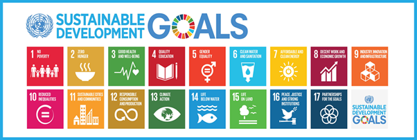
Figure 1. The Sustainable Development Goals (UN, 2015).
The SDGs provide a framework around which governments,
especially in developing countries, can develop policies and
encourage overseas aid programmes designed to alleviate poverty
and improve the lives of the poor. In particular, the SDGs
Target 1.4 (secure tenure rights to land) will not be achieved
with conventional land governance. Similarly, the land component
is referred to in target 3 of Goal 2 on ending hunger, and, more
generally in Goal 5 on gender equity, Goal 11 on sustainable
cities, Goal 15 on life on land, and Goal 16 on peace, justice
and strong institutions. These goals and targets will never be
achieved without having good land governance and
well-functioning countrywide land administration systems in
place. The SDGs represent a rallying point for NGOs to hold
governments to account. In other words, the SDGs are a key
driver for countries throughout the world – and especially
developing countries – to develop adequate and accountable land
policies and regulatory frameworks for meeting the goals.
2.1 The Wider Global Agenda
It should be recognised that, next to the SDGs, the wider
global agenda includes a range of global issues, such as
responsible governance of tenure, human rights and equity,
climate change and natural disasters, rapid urbanisation, and
the New Urban Agenda – see Figure 2.
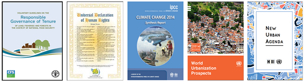
Figure 2. The wider global agenda includes a range of land
related issues.
Solutions to the overall global land issues relate to
alleviation of poverty, social inclusion and stability,
investments and economic development, and environmental
protection and natural resource management. These land matters
are now embedded in the SDGs and the land professionals are the
custodians of the systems dealing with these land issues and
responsible for delivering appropriate land administration
policies and services.
There is a strong requisite for effective monitoring and
assessment of progress in achieving the SDGs as provided through
the annual progress reports (UN 2017). There is a need for
reliable and robust data for devising appropriate policies and
interventions for the achievement of the SDGs and for holding
governments and the international community accountable. Such a
monitoring framework is crucial for encouraging progress and
enabling achievements at national, regional and global level.
This calls for a “data revolution” for sustainable development
to empower people with information on the progress towards
meeting the SDG targets (UN, 2014, p.7).
2.2 The FFP Response
The FFP approach is flexible, includes the adaptability to
meet the needs of society today and the outcome can be
incrementally improved over time, when required. The FFP
approach takes advantage of advances in technology development
that now allows for aerial / satellite imagery to be provided
quickly and at low / affordable costs. These imageries can be
used for identifying and recording the visible boundaries of the
individual land parcels rather than using conventional field
surveys and complying with high accuracy standards. The
identification and recording of visual boundaries is undertaken
in a participatory process involving the local community. The
participatory process may also include “walking the boundaries”
using handheld GPS to capture boundary corners on a tablet
imagery. This simple identification and recording can be
upgraded over time, e.g. triggered in response to social and
legal needs of economic development, investments and financial
opportunities that may emerge over the longer term. The FFP
approach thereby enables land rights to be secured for all in a
timely and affordable way. Similarly, the FFP approach looks at
recording all rights – legal as well as legitimate – and enables
for updating and upgrading over time in accordance with the
continuum of land rights (UN-HABITAT/GLTN, 2008). The FFP
approach also advocates for the use of a flexible ITC approach
and an integrated institutional framework without bureaucratic
barriers.
3. NEW AND EMERGING TECHNOLOGIES IN LAND ADMINISTRATION
The World Bank, with sponsorship from the Nordic Trust, has
recently published the “New Technology and Emerging Trends: The
State of Play for Land Administration” Guide (World Bank, 2017).
The Guide provides decision support to designers of Land
Administration programs requiring guidance on what new and
emerging technologies could be effectively adopted and
integrated within their programs. The Guide is positioned within
the context of implementing FFP land administration solutions
where technical solutions supporting the implementation of the
spatial framework need to be complemented by appropriate legal
and institutional frameworks. The Guide has the following target
audience:
- World Bank: Staff providing guidance to
developing countries designing their land administration
programs; staff specifying land administration programs for
developing countries;
- Donors: Donors providing guidance and
aid to developing countries designing their land
administration programs;
- Policy & Strategy Makers: Senior civil
servant decision-makers involved in formulating policies in
the land sector; senior level staff in land administration /
management agencies; and
- Implementers: Public and private sector
land professionals involved in land administration; NGOs /
CSOs.
3.1 Fit-For-Purpose (FFP) Land Administration Context of the
WB Guide
The FFP Land Administration approach (Enemark, et al., 2016)
provides an innovative and pragmatic solution to land
administration. The solution is focused on developing countries,
where current land administration solutions are not delivering,
with often up to 90 per cent of the land and population in
developing countries left outside the prevailing formal version.
The approach is directly aligned with country specific needs,
affordable, flexible to accommodate different types of land
tenure, and also upgradable when economic opportunities or
social requirements arise. It is highly participatory, can be
implemented quickly and aimed at providing security of tenure
for all. Most importantly, the FFP approach can start very
quickly using a low risk entry point that requires minimal
preparatory work. It can be applied to all traditions of land
tenure across the globe.
To significantly accelerate the process of recording land
rights, the FFP Land Administration approach advocates the use
of a range of scales of imagery as the spatial framework,
wherever feasible, on which to identify and record visible
tenure boundaries. This fast, affordable and highly
participatory approach is appropriate for the majority of land
rights boundaries. Using imagery also allows the spatial
framework to be used by many other land administration and
management activities and generate wider benefits.
Security of tenure does not in itself require precise surveys
of the boundaries. The most important aspect of security of
tenure for the majority of unregistered land parcels is
identification of the land object and its relation to
neighbouring objects, in relation to the connected legal or
social right. The absolute precision of the survey is less
important, except perhaps in high value land and properties, and
non-visible or contested boundaries when higher precision, but
more costly conventional ground survey methods and
monumentation, may be necessary.
Rather than mandating a single surveying specification for
capturing land rights across an entire country, the FFP approach
supports flexibility in adopting a variety of techniques to
capture the land rights depending on local circumstances, a
flexibility that will ensure lower costs and higher speeds in
the capture of land rights. However, this does require that
those designing the FFP projects are familiar with and able to
select the most suitable options from the myriad of emerging
technologies and solutions that show significant promise in
accelerating the process even more. This raises questions such
as:
- Which imagery (satellite, aerial or drone) and what
resolution are appropriate?
- Should we continue with paper orthophotomaps to support
mapping and adjudication participation? Or should we adopt
mobile technologies?
- How does urban density influence our choice of survey
technique?
- Do community mapping and rights adjudication tools have
a role to play within formal land administration systems,
and can they support mainstream activities?
- Is automatic extraction of linear and settlement
features suitable for land administration?
- Are modern SMS or other mass media approaches
appropriate to raise public awareness of land registration
programs?
- What are the key technological gaps and emerging
trends?
The purpose of the Guide is to provide designers of
country-specific FFP Land Administration strategies with
guidance on the current status of technology and emerging
trends. This should allow the most appropriate technical
solutions to be adopted in designing and implementing the
Spatial Framework for the FFP Land Administration approach. This
guidance aims to ensure that the capture, management and
dissemination of land rights information will be achieved using
the most cost-effective solutions, meets the precision and
accuracy requirements, matches the technical resources within
the country, is compatible with social cultures and can be
implemented quickly over large areas.
Therefore, the Guide should be used in conjunction with the
GLTN sponsored “Fit For Purpose Land Administration: Guiding
Principles for Country Implementation.” (Enemark, et al., 2016).
The FFP concept includes three core components: the spatial, the
legal, and the institutional frameworks – see Figure 3. Each of
these components includes the relevant flexibility to meet the
actual needs of today, yet can be improved incrementally over
time in response to societal needs and available financial
resources. The three framework components are inter-related and
form a conceptual nexus underpinned by the necessary means of
capacity development. Each of the frameworks must be
sufficiently flexible to accommodate and serve the current needs
of the country within different geographical, judicial, and
administrative contexts.
Hence, although the Guide covers technology solutions, it is
imperative that the decision making process on technology is
made with the full understanding of the impact on the legal and
institutional frameworks. Importantly, prior to building the
spatial framework and issuing any certificates of land rights,
it must be ensured that the regulations and institutions for
maintaining and updating the FFP land administration system are
in place. Without the institutional capacity and also incentives
for the parties to update the system in relation to the transfer
of land rights and land transfers, it will quickly be outdated
and unreliable and lead to waste of investments for building the
system in the first place.
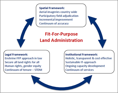
Figure 3: The Fit-For-Purpose Concept and associated
Frameworks (Enemark, et.al. 2016).
3.2 Scope of Technology Solutions and Approaches in the
Guide
The Guide reviews and assesses new technology solutions that
are currently operating successfully in land administration
systems, but also emerging disruptive technologies that could
significantly accelerate the land administration processes. This
will allow the risk of when, and if, to adopt this emerging
technology, to be judged. Although there have been advances in
supporting technologies such as enterprise content and document
management, optical character recognition and biometric
recording of individuals, these are not considered within the
Guide. This emerging technology includes, for example:
- Use of social media to engage with land stakeholders;
- Use of appropriate imagery sources (satellite,
airplane or drone) to map parcel boundaries, with AI or
crowd-sourced solutions to extract features from imagery,
and/or extraction of land parcel boundaries from point
clouds if LiDAR is collected simultaneously;
- Use of effective emerging methods for capturing rights
in the field using smartphones or tablets, and/or auto
geo-referencing of interpreted, participatory map-sketching;
and
- Use of cloud and/or blockchain technology for immutable
recording and management of rights.
These are particularly powerful when combined with less
recent technologies, such as:
- Use of freely-available satellite imagery and
OpenStreetMap (OSM) data for reconnaissance mapping of the
study area to identify possible issues and stakeholders;
- Use of portable digital devices and crowdsourcing
techniques to record inhabitants and attitudes (hopes and
fears) about land rights; and
- Use of modern data model standards (LADM and STDM) for
defining, recording and managing rights, restrictions and
responsibilities, especially ensuring no gender or other
bias.
The Guide clarifies which of the identified techniques are
fully operational, what is still in the early piloting phase and
what is still pure research. It is emphasized that the
technologies and approaches reviewed by the Guide do not
represent an exhaustive nor exclusive list, but provides an
indication of good practice and emerging trends that should be
reviewed alongside additional consultations. The technologies
and approaches included in the Guide are shown in the Table 1
below:
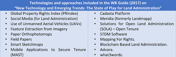
Table 1: Technologies Reviewed in Guide
3.3 Structure and Use of the Guide
The Guide leads the reader through the decision-making
process in identifying the most appropriate technology options
to be adopted in their land administration programs. There are
four main parts to the Guide:
- Role of Technology – Information Capture.
- Public Awareness and Preparation.
- Background Information Capture.
- Capturing Land Rights in the Field.
- Role of Technology – Managing, Maintaining and
Disseminating the Information.
- Data Management.
- Data Access.
- Further Key Considerations.
- This section identifies additional considerations
largely beyond the scope of technologies and approaches
reviewed, including institutional and legal frameworks,
capacity development and sustainability.
- Appendices
- Appendix A: Detailed descriptions of the new
and emerging technology solutions.
- Appendix B: Detailed discussion on key
considerations to support choice and implementation of
the technology solutions.
Sections 1 and 2 provide the following decision support
structure:
- A short description on the land administration component
processes covered by the selected section.
- A decision support diagram guiding the user through the
key decisions.
- The main body of text then directly addresses key
considerations and decisions to be made, referring to the
corresponding existing and emerging technology/approach
descriptions in Appendix A and additional ‘key
considerations’ sections in Appendix B.
- Short case study examples provide experiences with
applying the technologies.
The World Bank expects that the Guide will be instrumental in
paving the way forward towards implementing sustainable and
affordable land administration systems in developing countries,
enabling security of tenure for all and effective management of
land use and natural resources. This, in turn, will facilitate
economic growth, social equity, and environmental
sustainability.
4. EXPERIENCES IN IMPLEMENTING FFP LAND ADMINISTRATION AT
THE COUNTRY LEVEL
A well know example of implementing the FFP approach at
country level is the project in Rwanda of demarcating and
recording 10 million land parcels over five years for a cost of
6 USD parcel. This project was completed even before the FFP
principles were launched by FIG and the World Bank (FIG/WB
2014). Currently the FFP approach is being implemented in
countries such as Ethiopia and Mozambique. It should also be
mentioned, that many eastern European countries used such
flexible and low cost approaches in the 1990s when undergoing a
transition from centrally planned to market based economies.
However, the most recent experiences from Indonesia, Nepal and
Uganda are presented below.
4.1 Indonesia
Indonesia is the world´s fourth most populated country with a
land area close to 2 million km2 and a population of around 260
million people. It is estimated that Indonesia has about 120
million land parcels of which about one third are registered and
only about half of these are spatially identified. About 3
million new parcels appear each year.
Land administration in Indonesia is divided between
forestlands, administered by the Ministry of Environment and
Forestry (MoEF), and non-forest lands, administered by the
Ministry for Agrarian and Spatial Planning (BPN). This results
in duplication of policy, legal and institutional frameworks,
and precipitates unclear tenure arrangements and legal
recognition. The dualism also contributes to the slow
recognition of customary (“adat”) communities’ rights on land
and hinders the government’s ability to optimize land use and
protect resources (World Bank, 2016).
The lack of a unified spatial framework has created multiple
conflicts between communities and other land users (ibid). In
response, the Government of Indonesia introduced the One Map
Policy (OMP) as an effort to establish a unified, agreed-upon,
reference set of geospatial data that inform decision-making at
the national and sub-national levels. The current OMP
methodology aims to produce 1:50,000 scale maps based on over 80
thematic datasets and with limited or no ground verification.
However, in order to identify reliably the land use and
occupancy at the district and village levels, the OMP also
supports village boundaries mapping by district governments at a
scale of 1:10,000 or larger upon need. Furthermore, the
President has set a target for registering 5 million land
parcels in 2017, 7 million in 2018 and 9 million in 2019. This
target can only be achieved using a FFP approach, even though
some resistance is voiced, especially from the National Land
Agency (BPN). Some preliminary piloting has already taken place,
e.g. in Gresik District, East Java, see Figure 4.
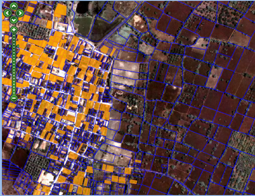
Figure 4. Example of demarcation of land parcels using high
resolution imagery.
Wotan Village, Gresik District, East Java Province, Indonesia
(Source: Gresik District Land Office)
Experience from this kind of FFP piloting looks very
promising, even though the legal & regulatory frameworks will
have to be adjusted in order to allow for mandatory registration
as part of the participatory process of boundary identification.
Overall, the benefits of implementing the FFP approach can be
summarised as shown in Table 2:
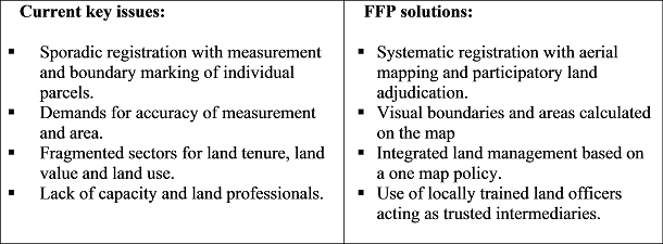
Table 2. FFP transition process in Indonesia.
The introduction of FFP land administration in Indonesia has
primarily been led and imposed on the institutions by the
President and driven by the priority land policy to introduce
security of tenure to support economic development. However,
success will depend on implementing institutional reform.
4.2 Nepal
The (then) Ministry of Land Reform and Management has been
working for a few years on developing a draft National Land
Policy. This policy aims to address the various land
administration and land reform issues that have remained
unresolved and under discussion for quite a long time in Nepal.
In Nepal, almost 28% of the total land area is arable and only
around 75 % of this is formally registered. The land
administration system does not deal with non-statutory or
informal land tenure. It is estimated that around 25% of the
total arable land and settlements are outside the formal
cadastre. This accounts for approximately 10 million parcels on
the ground, including occupied land parcels that legally belong
to either government, public or person/institution. This means
that a significant amount of the Nepalese population is living
in informality, without any spatial recognition and without
security of tenure.
The recent events, such as the mega earthquake of 2015 and post
disaster reconstruction and rehabilitation, the promulgation of
a new Constitution, and post conflict peace and social
rebuilding have ignited the need for developing a strategy for
implementation of the National Land Policy in the changed
context, see:
https://gltn.net/country-work/#nepal. The current Nepalese
land administration system (LAS) only deals with the formal or
statutory land tenure system, while there are three types of
non-statutory land tenure in the society: non-formal, in-formal
and encroachments, see Figure 5.
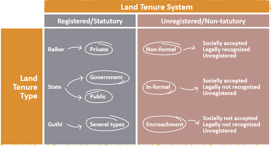
Figure 5. Tenure systems in Nepal (Source: Government of Nepal)
It is recognized that because of unsecured tenure, the settlers
hesitate to invest on the land to improve its productivity, and
without investment, production cannot be increased. All these
consequences show that the land under informal tenure is causing
huge loss to the economy and the valuable land asset is dumped
as “dead capital”, see Figure 6.
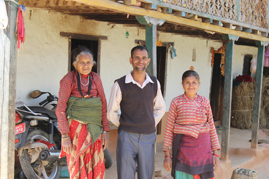
Figure 6. “Land administration is about people”. This family in
rural areas, about 20 km outside Kathmandu, has occupied a small
farm for four generations without any security of tenure to
enable investments and improvement of their livelihood (Photo:
Enemark, 2018).
Therefore, it was decided, in cooperation with UN-Habitat/GLTN
and Nepal civil society organisations, to develop an appropriate
strategy for implementing the latest provisions made in the
draft National Land Policy and the Constitution of Nepal. This
should ensure social justice on the one hand, and on the other
hand, lead to increased land productivity to support economic
growth. The strategy document integrates the resulting FFP
approach to land administration as a key solution to these
problems.
The strategy is strongly supported by government, including
Ministry of Agriculture, Land Management and the Survey
Department. Also, civil society organisations such as Community
Self Reliance Centre (CSRC) and the National Land Rights Forum
(NLRF) are very supportive, while some reluctance is voiced by
the professional land surveyors.
The draft strategy is currently (July 2018) under consideration
and adoption at the Parliament in Nepal, including a timescale
for implementation. The draft strategy document and an executive
summary is available at:
https://gltn.net/home/download/full-report-fit-for-purpose-land-administration-a-country-level-implementation-strategy-for-nepal/.
A summary report can be found at:
https://gltn.net/download/summary-report-fit-for-purpose-land-administration-a-country-level-implementation-strategy-for-nepal/.
4.3 Uganda
In Uganda, as in many Sub-Sahara African countries, colonial
governments introduced land administration systems to deal with
tenure insecurity. However, the tenure systems and procedures
for legal recognition of tenure rights were not oriented to the
context and realities of the African communities. The result is
that even after independence, many countries have only managed
to register less than 20% of their land.
The Constitution of the Republic of Uganda of 1995 (Chapter 15)
vests land in the citizens of Uganda hence giving powers to
citizens to own land privately as individuals, families or
communities. The 1995 constitution maintained the Freehold and
Leasehold tenure systems that were recognised under the colonial
laws. Furthermore, the 1995 constitution re-introduced the Mailo
Tenure system that is comparable to freehold, the difference
being the recognition of rights of occupants categorised under
the Land Act as bona fide or lawful. The constitution also
recognised customary tenure for the first time making it
possible for holders of customary rights in land to acquire
legal documents. Customary tenure accounts for approximately 80%
of land in Uganda see Figure 7.
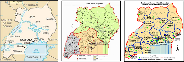
Figure 7. Left: Uganda, with a population of 28.3 million and an
area of 200.000 sq.km (excl. Lake Victoria waters), received
independence 1961 after 70 years of British colonization.
Middle: Land tenure in Uganda is divided between Native
freehold 22% (grey), Mailo 28% (yellow) and Customary 50%
(green). Right: Cadastral Information Branch Centres providing
local access to reliable land information. Source. Government of
Uganda.
Even though the Uganda Land Laws allow for registration of Mailo
(bona fide) titles and customary ownership (Certificate of
Customary Occupancy) these opportunities are not enforced in
practice. However, a number of recent pilot projects, carried
out by donors and civil society organisations, have introduced
the FFP concept as a vehicle for efficient and effective
systematic registration of land rights for the remaining about
20 million parcels currently outside the formal system. As the
challenges are enormous and the capacity of land stakeholders
limited, the Global Land Tool Network engages in Uganda to scale
up pro-poor land interventions in order to contribute to the
achievement of tenure security for all, see:
https://gltn.net/home/country-work/#uganda.

Figure 8. Left: Community people discussing the outcome of a
pilot project for registering land rights in the Mailo district
of Central Uganda. Right: A satellite imagery showing the mapped
parcel boundaries as demarcated though a participatory process
(Photo: Enemark, 2018).
The experiences of the pilot project are very promising and
well-received by government as well as at the community level.
Teams have been created, consisting a volunteer acting as
locally trained land officer and two representatives from local
government, to complete the parcel demarcation based on visual
boundaries as shown on large-scale satellite imagery or captured
in the field with hand held GPS.
The Government of Uganda has now engaged with UN-Habitat/GLTN to
develop a National Strategy for implementing a FFP approach to
land administration. The aim is to register 20 million parcels
within the next 10 years for a cost of around 10 USD per parcel.
This base cost does not include further costs relate to
institutional development, awareness raising and capacity
development.
The draft strategy presents the FFP concept and an assessment of
the current land administration system in terms of shortcomings
and constraints of delivering secure tenure for all. The
requirements for building the spatial, legal and institutional
framework is then presented along with the crosscutting issues,
such as capacity development and budgetary costs over a period
of 10 years. The draft strategy was recently (August 2018)
presented and discussed at a workshop with attendance of all the
key stakeholders and the final version is expected by the end of
September 2018 for further discussion and approval at Parliament
level.
The strategy is well supported at the Prime Minister level,
parts of the ministry of Lands, Housing and Urban Development,
and various civil society organisations. Some other stakeholder,
such as private licensed surveyors still voice some reservations
even though there is a growing understanding of relevance of
replacing costly field surveys with simple positioning at a
lower accuracy, supported by boundary corner plants. This also
relates to understanding the benefits deriving from a new role
as land professionals being the custodians of a countrywide land
administration system. Overall, the case of Uganda is very
interesting for testing the implementation of the FFP approach
at a national scale.
5. CONCLUDING REMARKS
There is a consensus that governing the people to land
relationship is at the heart of the 2030 global agenda. There is
an urgent need to build simple and basic systems using a
flexible and affordable approach to identify the way land is
occupied and used, whether these land rights are legal or
locally legitimate. The systems need to be simple and flexible
in terms of spatial identification, legal regulations and
institutional arrangements to meet the actual needs in society
today and they can then be incrementally improved over time.
Building such spatial, legal, and institutional frameworks will
establish the link and trust between people and land. This is
possible due to emerging, game changing technology developments
that enable mapping and registration procedures to be
undertaking at much simpler, cost efficient and participatory
ways. In turn, this will enable the management and monitoring of
improvements in meeting aims and objectives of adopted land
policies as well as meeting the global agenda. The results of
the current country implementations of FFP land administration
happening worldwide will make this approach compelling and
widely adopted. At last there will be a scalable land
administration solution implemented across the globe to
eliminate the scourge of insecurity of tenure. All land
professionals need to embrace and fully support this approach.
REFERENCES
Enemark, S., McLaren, R. and Lemmen, C. (2016): (2016):
Fit-For-Purpose Land Administration – Guiding Principles for
Country Implementation. UN-Habitat / GLTN, Nairobi, 120 p.
https://unhabitat.org/books/fit-for-purpose-land-administration-guiding-principles-for-country-implementation/
FIG/WB (2014): Fit-for-Purpose Land Administration. FIG
Publication No. 60.
http://www.fig.net/pub/figpub/index.htm
UN (2014): The Millennium Development Goals Report 2014.
http://www.un.org/en/development/desa/publications/mdg-report-2014.html
UN (2015): 2015 is the Time for Global Action.
http://www.un.org/sustainabledevelopment/
UN (2017): The Sustainable Development Goals report 2017.
https://unstats.un.org/sdgs/report/2017/
UN-HABITAT/GLTN (2008): Secure Land Rights for All.
https://unhabitat.org/books/secure-land-rights-for-all/
World Bank (2016): Terms of Reference for Technical
Assistance and Capacity Development for the Program Preparation
to Operationalize and Accelerate the One Map Policy.
World Bank (2017): ‘New Technology and Emerging Trends: The
State of Play for Land Administration’. Washington DC, USA.
https://www.conftool.com/landandpoverty2018/index.php/14-07-McLaren-186_ppt.pdf?page=downloadPaper&filename=14-07-McLaren-186_ppt.pdf&form_id=186&form_index=2&form_version=finalNUn
(2017)
BIOGRAPHICAL NOTES
Stig Enemark is Honorary President of the International
Federation of Surveyors, FIG (President 2007-2010). He is
Professor Emeritus of Land Management at Aalborg University,
Denmark. He is now working as an international consultant in
land administration and capacity development.
Email: enemark[at]land.aau.dk
Web:
http://personprofil.aau.dk/100037?lang=en
Robin McLaren is director of the independent consulting company
Know Edge Ltd, UK. He has supported many national governments in
formulating land reform programmes and National Spatial Data
Infrastructure (NSDI) strategies.
Email:
robin.mclaren[at]KnowEdge.com
Web: www.KnowEdge.com