Article of the Month -
December 2010
|
From Cadastre to Land Governance in Support of the
Global Agenda - The Role of Land Professionals and FIG
Stig ENEMARK, FIG President 2007-2010
Professor in Land Management, Aalborg University, Denmark

 This article in .pdf-format (23
pages, 3.29 MB)
This article in .pdf-format (23
pages, 3.29 MB)
1) The paper facilitates an
understanding of how the cadastral concept has evolved over time into
the broader concept of Land Administration Systems in support of sound
Land Governance. The role of land professionals and FIG is underlined in
this regard. The paper also represents the essence of a range of papers
presented by the author as President of FIG over the term of office
2007-2010.
1. INTRODUCTION
In most countries, the cadastral system is just taken for granted,
while the impact of the system in terms of facilitating an efficient
land market and supporting effective land-use administration is not
fully recognised. The reality is that the impact of a well-functioning
cadastral system can hardly be overestimated. A well-tailored cadastral
system is in fact acting as a backbone in society.
The famous Peruvian economist Hernando de Soto has put it this way:
“Civilized living in market economies is not simply due to greater
prosperity but to the order that formalized property rights bring” (De
Soto, 1993). The point is that the cadastral system provides security of
property rights. The cadastral systems thereby paves the way for
prosperity – provided that the basic land policies are implemented to
govern the basic land issues, and provided that sound institutions are
in place to secure good governance of all issues related to land and
property. This institutional context is of course country unique.
Since the early 1990´s there has been a major evolution in this area
of land administration. FIG has played a significant role in terms of
facilitating the understanding of the role of land administration, and
by establishing a powerful link between appropriate land administration
and sustainable development.
2. EVOLUTION OF CADASTRAL SYSTEMS
Throughout the world, the cadastral concept has developed
significantly over the past few decades. The most recent examples are
current world concerns of environmental management, sustainable
development and social justice.
The human kind to land relationship is dynamic and is changing over
time as a response to general trends in societal development. In the
same way, the role of the cadastral systems is changing over time, as
the systems underpin these societal development trends. In the Western
world this dynamic interaction may be described in four phases as shown
in figure 1 below.
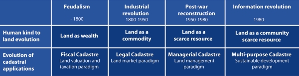
Figure 1: Evolution of Western Cadastral System (Developed from
Williamson and Ting, 1999)
Over the last few decades land is increasingly seen as a community
scarce resource. The role of the cadastral systems has then evolved to
be serving the need for comprehensive information regarding the
combination of land-use and property issues. New information technology
provides the basis for this evolution. This forms the new role of the
cadastral systems: the multi-purpose cadastre.
2.1 The FIG Agenda
The international development in the area of Cadastre and Land
Administration has been remarkable with FIG taking a leading role.
Throughout the last 10-15 years a number of initiatives have been taken
with a focus to explain the importance of sound land administration
systems as a basis for achieving “the triple bottom line” in terms of
economic, social and environmental sustainability. International
organizations such as UN, FAO, HABITAT and especially the World Bank
have been key partners in this process.
The International Federation of Surveyors (FIG, 1995) defines a
cadastre as a “parcel based and up-to-date land information system
containing a record of interests in land (e.g. rights, restrictions and
responsibilities). It usually includes a geometric description of land
parcels linked to other records describing the nature of the interests,
ownership or control of those interests, and often the value of the
parcel and its improvements. It may be established for fiscal purposes
(valuation and taxation), legal purposes (conveyancing), to assist in
the management of land and land-use control (planning and
administration), and enables sustainable development and environmental
improvement”.
A rage of publications is presented below showing the impact of the
FIG agenda.
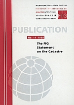 |
In 1995 FIG published an important and very
timely publication entitled “The FIG statement on the Cadastre”.
In many countries throughout the world the cadastral systems
were revised, mainly due to technology development. Cadastral
reform was on the agenda in most developing countries. At the
same time, there was also an increasing focus on the cadastral
systems in Eastern Europe – the so-called countries in
transition. And in the third world there was an increasing
awareness about the importance of these systems as a basis for
developing a modern and market oriented society. The FIG
Statement on the Cadastre, this way, established a standard. The
concepts were explained, settled, and made operational according
to the specific conditions in different parts of the world. |
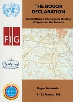 |
The co-operation between FIG and the
UN-organizations was strongly intensified through the second
half of the 1990´s. The so-called Bogor Declaration is a good
example as a result of an interregional meeting of cadastral
experts held in Bogor, Indonesia, March 1996. The Bogor meeting
was based on a recommendation from the UNRCC-AP Conference in
Beijing in 1994. The meeting was also part of the efforts to
develop an active response to the problems of land management
and environmental protection as stipulated in Agenda 21 from
“The Earth Summit” in Brazil 1992. The cadastral systems were
hereby officially recognized for the first time as a core part
of the infrastructure supporting a sustainable environmental and
nature resource management. |
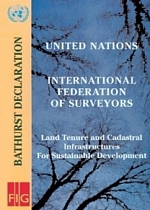 |
The Bathurst Conference was organized by FIG
Commission 7 and attracted 40 invited experts from 23 countries.
Half of the participants were surveyors from FIG, the other half
experts from other professions and representatives from UN
organizations such as UNDP, FAO, UN-HABITAT and the World Bank.
The Bathurst conference examined the major issues relevant to
strengthening land policies, institutions and infrastructures.
The resulting Bathurst Declaration on Land Tenure and Cadastral
Infrastructures for Sustainable Development established a
powerful link between good land administration and sustainable
development and provided a range of recommendations on how land
tenures and land administration infrastructures should evolve to
meet the challenges of upcoming 21st Century. |
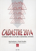 |
The cadastral systems differ throughout the
world in terms of purpose, content and design and the technical
and economic effectiveness vary a lot. There was a need for a
vision for future cadastral systems to fulfil a multipurpose
role and in response to technology development. “Cadastre 2014”
presented such a vision in terms of six statements for
development of cadastral systems over the following years
towards 2014. The vision is based on a fully digital environment
and using privatisation and cost recovery as the core
organisational components. This publication of FIG Commission 7
has obtained remarkable international attention and established
a new agenda for discussing the cadastral issues. The
publication is translated into a range of foreign languages.
|
2.2 Cadastral Systems
In the Western cultures it would be hard to imagine a society without
having property rights as a basic driver for development and economic
growth. Property is not only an economic asset. Secure property rights
provide a sense of identity and belonging that goes far beyond and
underpins the values of democracy and human freedom. Historically,
however, land rights evolved to give incentives for maintaining soil
fertility, making land-related investments, and managing natural
resources sustainably.
Therefore, property rights are normally managed well in modern
economies. The main rights are ownership and long term leasehold. These
rights are typically managed through the cadastral/land registration
systems developed over centuries. Other rights such as easements and
mortgage are often included in the registration systems.
Cadastral Systems are organized in different ways throughout the
world, especially with regard to the Land Registration component (figure
2). Basically, two types of systems can be identified: the Deeds System
and the Title System. The differences between the two concepts relate to
the cultural development and judicial setting of the country. The key
difference is found in whether only the transaction is recorded (the
Deeds System) or the title itself is recorded and secured (the Title
System). The Deeds System is basically a register of owners focusing on
“who owns what” while the Title System is a register of properties
presenting “what is owned by whom”. The cultural and judicial aspects
relate to whether a country is based on Roman law (Deeds Systems) or
Germanic or common-Anglo law (Title Systems). This of course also
relates to the history of colonization.
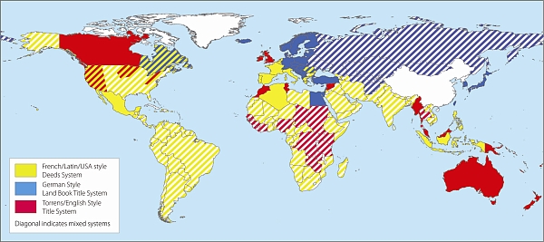
Figure 2. World map of land registration systems (after Enemark
2004)
International experience suggests three basic approaches to cadastral
systems. These approaches are based on countries grouped according to
their similar background and legal contexts (German style,
Torrens/English approach, and French/Latin style). While each system has
its own unique characteristics, most cadastres can be grouped under one
of these three approaches. Just as there are three different styles of
land registration systems, these translate to three different roles that
the cadastre plays in each system. Again, while the role of the cadastre
and the land registration styles are not definitive, figure 3 describes
the three approaches in general terms.
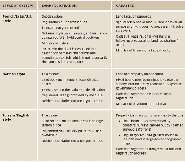
Figure 3. General relationships between land registries and
cadastres.
(Williamson, Enemark, Wallace, Rajabifard, 2010)
2.3 The Multipurpose Cadastre
Modern land administration theory acknowledges the history of the
cadastre as a central tool of government infrastructure and highlights
its central role in implementing the land management paradigm. However,
given the difficulty of finding a definition that suits every version it
makes sense to talk about cadastral systems rather than just cadastres
(figure 4). These systems incorporate both the identification of land
parcels and the registration of land rights. They support the valuation
and taxation of land and property, as well as the administration of
present and possible future uses of land. Multipurpose cadastral systems
support the four functions of land tenure, value, use, and development
to deliver sustainable development.
By around 2000, cadastral systems were seen as a multipurpose engine
of government operating best when they served and integrated
administrative functions in land tenure, value, use, and development and
focused on delivering sustainable land management. A mature multipurpose
cadastral system could even be considered a land administration system
in itself.
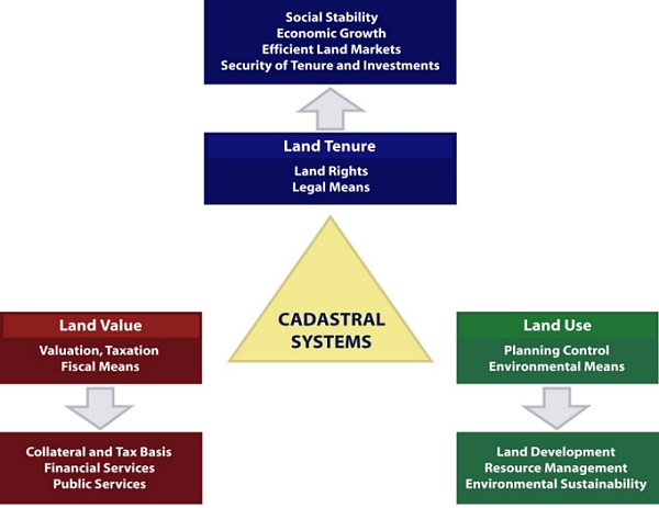
Figure 4: Cadastral systems provide a basic land information
infrastructure for running the interrelated systems within the areas of
Land Tenure, Land Value, and Land Use (Enemark, 2004).
2.4 Comparing and Improving Cadastral Systems
A website has been established
http://www.cadastraltemplate.org to compare cadastral systems on a
worldwide basis. About 42 countries are currently included (August 2010)
and the number is still increasing. The web site is established by
Working Group 3 (Cadastre) of the PCGI-AP (Permanent Committee on GIS
Infrastructure for Asia and the Pacific). The cadastral template is
basically a standard form to be completed by cadastral organizations
presenting their national cadastral system. The aim is to understand the
role that a cadastre plays in a state or a National Spatial Data
Infrastructure (NSDI), and to compare best practice as a basis for
improving cadastres as a key component of NSDIs. The project is carried
out in collaboration with FIG Commission 7 (Cadastre and Land
Management), which has extensive experience in comparative cadastral
studies. (Steudler, et.al. 2004).
It is generally accepted, however, that a good property system is a
system where people in general can participate in the land market having
a widespread ownership where everybody can make transactions and have
access to registration. The infrastructure supporting transactions must
be simple, fast, cheap, reliable, and free of corruption. It is
estimated that only 25-30 countries in the world apply to these
criteria.
2.5 Limitations of formal cadastral systems
It is recognized that these legal or formal systems do not serve the
millions of people whose tenures are predominantly social rather than
legal. “Rights such as freehold and registered leasehold, and the
conventional cadastral and land registration systems, and the way they
are presently structured, cannot supply security of tenure to the vast
majority of the low income groups and/or deal quickly enough with the
scale of urban problems. Innovative approaches need to be developed”
(UN- HABITAT 2003). This should include a “scaling up approach” that
include a range of steps from informal to more formalised land rights.
This process does not mean that the all societies will necessarily
develop into freehold tenure systems. Figure 5 shows a continuum of land
rights where each step in the process can be formalised, with registered
freeholds offering a stronger protection, than at earlier stages.
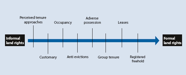
Figure 5. Continuum of land rights (UN-Habitat, 2008).
Most developing countries have less than 30 per cent cadastral
coverage. This means that over 70 per cent of the land in many countries
is generally outside the land register. This has caused enormous
problems for example in cities, where over one billion people live in
slums without proper water, sanitation, community facilities, security
of tenure or quality of life. This has also caused problems for
countries with regard to food security and rural land management issues.
The security of tenure of people in these areas relies on forms of
tenure different from individual freehold. Most off register rights and
claims are based on social tenures. The Global Land Tool Network (GLTN),
facilitated by UN-HABITAT is a coalition of international partners (such
as FIG) who has taken up this challenge and is supporting the
development of pro-poor land management tools, to address the technical
gaps associated with unregistered land, the upgrading of slums, and
urban and rural land management. GLTN partners support a continuum of
land rights (figure 5), which include documented as well as undocumented
land rights, from individuals and groups, and in slums which are legal
as well as illegal and informal.
This range of rights generally cannot be described relative to a
parcel, and therefore new forms of spatial units are needed. A model has
been developed to accommodate these social tenures, termed the Social
Tenure Domain Model (STDM). A first prototype of STDM is available. This
is a pro-poor land information management system that can be used to
support the land administration of the poor in urban and rural areas,
which can also be linked to the cadastral system in order that all
information can be integrated.
The need for a complete coverage of all land by Land Administration
Systems is urgent. Not only for the registration of formal rights and
for the recordation of informal and customary rights. Also for managing
the value, the use of land and land development plans. This relates to
the global land administration perspective presented in Figure 6 below.
Complete coverage of all land in a Land Administration System is only
possible with an extendable and flexible model such as STDM that enables
inclusion of all land and all people within the four land administration
functions. So STDM will close part of the technical gap in developing
countries in terms of making Land Administration cover the total
territory.
 |
The FIG Working Group 7.1 of Commission 7 on
Cadastre and Land Management took the lead from 2002 onwards, in
the development of the STDM in close co-operation with
UN-HABITAT. ITC, financially supported by the GLTN, developed a
first prototype of STDM that is supported by the World Bank. The
FIG Publication 52 presents the need for STDM, the properties of
STDM as a tool, and the benefit and use of STDM as a key means
of meeting the Millennium Development Goals (MDGs). Land tenure
types, which are not based on formal cadastral parcels and which
are not registered, require new forms of land administration
systems. STDM is a pro-poor land tool aiming to include informal
land rights into flexible, unconventional systems of land
administration that eventually can be incorporated into more
formal systems. |
3. LAND ADMINISTRATION SYSTEMS
When countries in Eastern and Central Europe changed from command
economies to market economies in the early 1990s, the UN Economic
Commission for Europe (UNECE) saw the need to establish the Meeting of
Officials on Land Administration (MOLA). In 1996, MOLA produced Land
Administration Guidelines (UN-ECE 1996) as one of its many initiatives.
In 1999, MOLA became the UN-ECE Working Party on Land Administration
(WPLA).
 |
The UN-ECE Guidelines on Land Administration
was sensitive to there being too many strongly hold views in
Europe of what constituted a cadastre. Another term was needed
to describe these land-related activities. It was recognized
that any initiatives that primarily focused on improving the
operation of land markets had to take a broader perspective to
include planning or land use as well as land tax and valuation
issues. As a result, the publication replaced “cadastre” with
the term “land administration”. Widening the concept of a
cadastre to include land administration reflected its variety of
uses throughout the world and established a globally inclusive
framework for the discipline. An updated version of the
guidelines was published in 2005: “Land administration in the
UNECE region: Development trends and main principles”. |
For the first time, efforts to reform developing countries, to assist
countries in economic transition from a command to a market-driven
economy, and to help developed countries improve LAS could all be
approached from a single disciplinary standpoint, at least in theory.
That is, to manage land and resources “from a broad perspective rather
than to deal with the tenure, value, and use of land in isolation” (Dale
and McLaughlin 1999, preface).
Consolidation of land administration as a discipline in the 1990s
reflected the introduction of computers and their capacity to reorganize
land information. UN-ECE viewed land administration as referring to “the
processes of determining, recording, and disseminating information about
the ownership, value, and use of land, when implementing land management
policies” (UN-ECE 1996) The emphasis on information management
served to focus land administration systems on information for policy
makers, reflecting the computerization of land administration agencies
after the 1970s.
3.1 A global land management perspective
The focus on information remains but the need to address land
management issues systematically pushes the design of land
administration systems (LAS) toward an enabling infrastructure for
implementing land policies and land management strategies in support of
sustainable development. In simple terms, the information approach needs
to be replaced by a model capable of assisting design of new or
reorganized land administration systems to perform the broader and
integrated functions now required. Such a global perspective is
presented in figure 6 below.
Land management covers all activities associated with the management
of land and natural resources that are required to fulfil political and
social objectives and achieve sustainable development. The operational
component of the concept is the range of land administration functions
that include the areas of land tenure, land value; land use; and land
development.
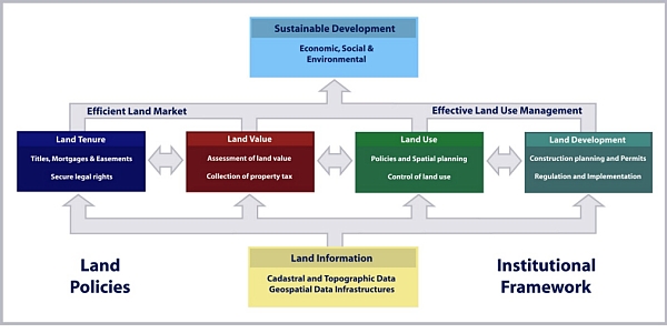
Figure 6. A Global land management perspective (Enemark, 2004)
The four land administration functions (land tenure, land value, land
use, and land development) are different in their professional focus,
and are normally undertaken by a mix of professionals, including
surveyors, engineers, lawyers, valuers, land economists, planners, and
developers. Furthermore, the actual processes of land valuation and
taxation, as well as the actual land-use planning processes, are often
not considered part of land administration activities. However, even if
land administration is traditionally centred on cadastral activities in
relation to land tenure and land information management, modern land
administration systems designed as described in figure 6 deliver an
essential infrastructure and encourage integration of the four
functions:.
- Land Tenure: the allocation and security of rights in
lands; the legal surveys of boundaries; the transfer of property
through sale or lease; and the management and adjudication of
disputes regarding rights and boundaries.
- Land Value: the assessment of the value of land and
properties; the gathering of revenues through taxation; and the
management and adjudication of land valuation and taxation disputes.
- Land-Use: the control of land-use through adoption of
planning policies and land-use regulations at various government
levels; the enforcement of land-use regulations; and the management
and adjudication of conflicts regarding land-use and natural
resources.
- Land Development: the building of new infrastructure; the
implementation of construction planning; and the change of land-use
through planning permission and schemes for renewal and change of
existing land use
From this global perspective, land administration systems act within
adopted land policies that define the legal regulatory pattern for
dealing with land issues. They also act within an institutional
framework that imposes mandates and responsibilities on the various
agencies and organisations. LAS designed this way forms a backbone for
society and is essential for good governance because it delivers
detailed information and reliable administration of land from the basic
foundational level of individual land parcels to the national level of
policy implementation.
3.2 The FIG Agenda
FIG is strongly committed to the Millennium Development Goals and the
UN-Habitat agenda on the Global Land Tool Network. FIG should identify
their role in this process and spell out the areas where the global
surveying profession can make a significant contribution. Issues such as
tenure security, pro-poor land management, and good governance in land
administration are all key issues to be advocated in the process of
reaching the goals. Measures such as capacity assessment, institutional
development and human resource development are all key tools in this
regard. In pursuing this agenda FIG is working closely with the UN
agencies and the World Bank in merging our efforts of contributing to
the implementation of the MDGs. This provides a platform for focusing on
specific issues of mutual interest such as taking the land
administration agenda forward. At the same time it will contribute
further to the well founded cooperation between FIG and our UN partners.
In recent years FIG has established a number of relevant initiatives. A
rage of publications is presented below showing the impact of the FIG
agenda.
 |
Following the Bathurst Declaration in 1999 a
number of FIG initiatives looked at addressing the goal of the
global agenda namely sustainable development. FIG published a
policy statement in 2001 on FIG Agenda 21 (FUG pub. 23) and a
report with guidelines on Women´s access to land with some key
principles for equitable gender inclusion in land administration
(FIG pub. 24). Sustainable development was also in focus in
the Nairobi Statement on Spatial Information for Sustainable
Development (FIG pub. 30) and the following best practice
guidelines on city-wide land information management (FIG pub.
31) both published as an outcome of 1st FIG regional conference
in Nairobi 2002.
The concept of organising regional conferences has proven to
be strong by bringing FIG to various regions in the world
especially developing countries and providing a unique
opportunity to address issues at the top of the regional and
local agenda. The resulting FIG publications include: The
Marrakech Declaration on Urban-Rural Development for Sustainable
Development (FIG pub. 33, 2004); The Costa Rica Declaration on
Pro-Poor Coastal Zone Management (FIG pub. 43, 2008); and the
Hanoi Declaration on Land Acquisition in Emerging Economies (FIG
pub. 51, 2010).
A pro-poor approach to land administration and management has
been addressing through the report on Informal Settlements – The
Road towards more Sustainable Places (FIG pub. 42, 2008) and the
comprehensive report on Improving Slum Conditions through
Innovative Financing (FIG pub. 44, 2008) produced as an outcome
of the joint FIG/UN-Habitat seminar during the FIG Working Week
in Stockholm, June 2008. The pro-poor approach has been further
addressed through development of the Social Tenure Domain Model
(FIG pub. 52, 2010) in cooperation with GLTN, UN-Habitat.
The big challenges on the global agenda such as climate
change, natural disasters, and rapid urban growth have been
addressed in The Contribution of the Surveying Profession to
Disaster Risk Management (FIG pub. 38, 2006) and the research
study on Rapid urbanisation and Mega Cities: The Need for
Spatial Information management (FIG pub. 48, 2010).
The overall challenge of Good Land Governance in support of
the global agenda has been analysed in cooperation with the
UN-agencies and the World Bank. Key outcomes have been the
Aguascalientes Statement on Development of Land Information
Policies in the Americas (FIG pub. 34, 2005) and the very recent
key publication on Land Governance in Support of the Millennium
Development Goals (FIG pub. 45, 2010) resulting from the joint
FIG/World Bank conference held in Washington, March 2009. Based
on this conference the World Bank has also published a joint
WB/FIG/GLTN/FAO publication “Innovations in Land Rights
Recognition, Administration and Governance”. |
4. LAND GOVERNANCE
All countries have to deal with the management of land. They have to
deal with the four functions of land tenure, land value, land use, and
land development in some way or another. A country’s capacity may be
advanced and combine all the activities in one conceptual framework
supported by sophisticated ICT models. More likely, however, capacity
will involve very fragmented and basically analogue approaches.
Different countries will also put varying emphasis on each of the four
functions, depending on their cultural basis and level of economic
development.
Arguably sound land governance is the key to achieve sustainable
development and to support the global agenda set by adoption of the
Millennium Development Goals (MDGs). Land governance is about the
policies, processes and institutions by which land, property and natural
resources are managed. Land governance covers all activities associated
with the management of land and natural resources that are required to
fulfil political and social objectives and achieve sustainable
development. This includes decisions on access to land, land rights,
land use, and land development.
4.1 The Land management Paradigm
The cornerstone of modern land administration theory is the land
management paradigm in which land tenure, value, use and development are
considered holistically as essential and omnipresent functions performed
by organised societies. Within this paradigm, each country delivers its
land policy goals by using a variety of techniques and tools to manage
its land and resources. What is defined as land administration within
these management techniques and tools is specific to each jurisdiction,
but the core ingredients, cadastres or parcel maps and registration
systems, remain foundational. These ingredients are the focus of modern
land administration, but they are recognised as only part of a society’s
land management arrangements. The land management paradigm is
illustrated in figure 7 below.
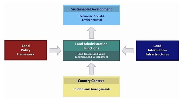
Figure 7. The land management paradigm (Enemark, 2004)
The Land management paradigm allows everyone to understand the role
of the land administration functions (land tenure, land value, land use,
and land development) and how land administration institutions relate to
the historical circumstances of a country and its policy decisions.
Importantly, the paradigm provides a framework to facilitate the
processes of integrating new needs into traditionally organised systems
without disturbing the fundamental security these systems provide. While
sustainability goals are fairly loose, the paradigm insists that all the
core land administration functions are considered holistically, and not
as separate, stand-alone, exercises.
Land policy is simply the set of aims and objectives set by
governments for dealing with land issues. Land policy is part of the
national policy on promoting objectives such as economic development,
social justice and equity, and political stability. Land policies vary,
but in most countries they include poverty reduction, sustainable
agriculture, sustainable settlement, economic development, and equity
among various groups within the society.
Land management activities reflect drivers of globalization and
technology. These stimulate the establishment of multifunctional
information systems, incorporating diverse land rights, land use
regulations, and other useful data. A third driver, sustainable
development, stimulates demands for comprehensive information about
environmental, social, economic, and governance conditions in
combination with other land related data.
The operational component of the land management paradigm is the
range of land administration functions (land tenure, value, use and
development) that ensure proper management of rights, restrictions,
responsibilities and risks in relation to property, land and natural
resources.
Sound land management requires operational processes to implement
land policies in comprehensive and sustainable ways. Many countries,
however, tend to separate land tenure rights from land use
opportunities, undermining their capacity to link planning and land use
controls with land values and the operation of the land market. These
problems are often compounded by poor administrative and management
procedures that fail to deliver required services. Investment in new
technology will only go a small way towards solving a much deeper
problem: the failure to treat land and its resources as a coherent
whole.
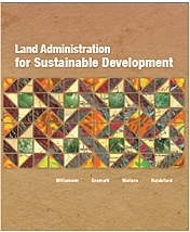 |
The recent book Land Administration for
Sustainable Development (Williamson, Enemark, Wallace,
Rajabifard, 2010) explores the capacity of the systems that
administer the way people relate to land. A land administration
system provides a country with the infrastructure to implement
land policies and land management strategies. From the origin of
the cadastre in organising land rights to the increasing
importance of spatially enabled government in an ever changing
world, the book emphasises the need for strong geographic and
land information systems to better serve our world. |
4.2 Good Governance
Governance refers to the manner in which power is exercised by
governments in managing a country’s social, economic, and spatial
recourses. It simply means: the process of decision-making and the
process by which decisions are implemented. This indicates that
government is just one of the actors in governance. The concept of
governance includes formal as well as informal actors involved in
decision-making and implementation of decisions made, and the formal and
informal structures that have been set in place to arrive at and
implement the decision. Good governance is a qualitative term or an
ideal which may be difficult to achieve. The term includes a number of
characteristics:
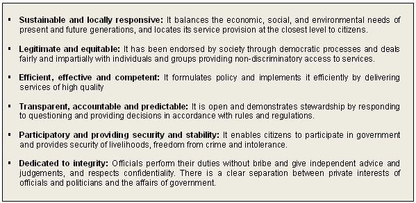
Figure 8. Characteristics of Good Governance (adapted from FAO,
2007)
5. THE CADASTRE AS AN ENGINE OF LAS
The land management paradigm makes a national cadastre the engine of
the entire LAS, underpinning the country’s capacity to deliver
sustainable development. This is shown diagrammatically in figure 9. The
diagram highlights the usefulness of the large scale cadastral map as a
tool by exposing its power as the representation of the human scale of
land use and how people are connected to their land.
Wherever the cadastre sits in a national land administration system,
ideally it should assist the functions of land tenure, value, use, and
development. This way the cadastral system becomes the core technical
engine delivering the capacity to control and manage land through the
four land administration functions. They support business processes of
tenure and value, depending on how the cadastre is locally built. They
identify legal rights, where they are, the units that form the
commodities and the economy related to property. These cadastres are
much more than a layer of information in national SDI.
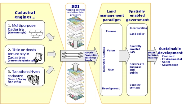
Figure 9. The cadastre as an engine of LAS - the “butterfly”
diagram
(Williamson, Enemark, Wallace, Rajabifard, 2010)
The diagram is a virtual butterfly: one wing represents the cadastral
processes, and the other the outcome of using the processes to implement
the land management paradigm. Once the cadastral data (cadastral or
legal parcels, properties, parcel identifiers, buildings, legal roads,
etc.) are integrated within the SDI, the full multipurpose benefit of
the LAS, so essential for sustainability, can be achieved.
The body of the butterfly is the SDI, with the core cadastral
information sets acting as the connecting mechanism. This additional
feature of cadastral information is an additional role, adding to the
traditional multipurpose of servicing the four functions. This new
purpose takes the importance of cadastral information beyond the land
administration framework by enlarging its capacity to service other
essential functions of government, including emergency management,
economic management, effective administration, community services, and
many more functions.
The diagram demonstrates that the cadastral information layer cannot
be replaced by a different spatial information layer derived from
geographic information systems (GIS). The unique cadastral capacity is
to identify a parcel of land both on the ground and in the system in
terms that all stakeholders can relate to, typically an address plus a
systematically generated identifier (given addresses are often
duplicated or are otherwise imprecise). The core cadastral information
of parcels, properties and buildings, and in many cases legal roads,
thus becomes the core of SDI information, feeding into utility
infrastructure, hydrological, vegetation, topographical, images, and
dozens of other datasets.
5.1 Spatially enabled society
Place matters! Everything happens somewhere. If we can understand
more about the nature of “place” where things happen, and the impact on
the people and assets on that location, we can plan better, manage risk
better, and use our resources better (Communities and Local Government,
2008). Spatially enabled government is achieved when governments use
place as the key means of organising their activities in addition to
information, and when location and spatial information are available to
citizens and businesses to encourage creativity.
New distribution concepts such as Google Earth provide user friendly
information in a very accessible way. Consider the option where spatial
data from such concepts are merged with built and natural environment
data. This unleashes the power of both technologies in relation to
emergency response, taxation assessment, environmental monitoring and
conservation, economic planning and assessment, social services
planning, infrastructure planning, etc. This also include design and
implementation of a suitable service oriented IT-architecture for
organising spatial information that can improve the communication
between administrative systems and also establish more reliable data
based on the use of the original data instead of copies.
The technical core of Spatially Enabling Government is the spatially
enabled cadastre. “Spatially enabled society is about managing
information spatially – not managing spatial information” (Williamson,
2010).
6. THE GLOBAL AGENDA
The eight Millennium Development Goals (MDGs) form a blueprint agreed
to by all the world’s countries and the world’s leading development
institutions. The first seven goals are mutually reinforcing and are
directed at reducing poverty in all its forms. The last goal - global
partnership for development - is about the means to achieve the first
seven. These goals are now placed at the heart of the global agenda. To
track the progress in achieving the MDGs a framework of targets and
indicators is developed. This framework includes 18 targets and 48
indicators enabling the on-going monitoring of the progress that is
reported on annually (UN, 2000).
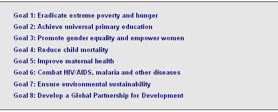
Figure 10. The Eight Millennium Development Goals
The MDGs represent a wider concept or a vision for the future, where
the contribution of the global surveying community is central and vital.
This relates to the areas of providing the relevant geographic
information in terms of mapping and databases of the built and natural
environment, and also providing secure tenure systems, systems for land
valuation, land use management and land development. These aspects are
all key components within the MDGs.
The global challenge can be displayed through a map of the world
(figure 11) where the territory size shows the proportion of worldwide
wealth based on the Gross Domestic Product. In surveying terms, the real
challenge of the global agenda is about bringing this map back to scale.
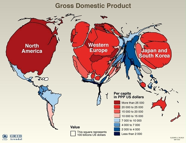
Figure 11. Map of the world where the territory size is shown
based on the Gross Domestic Product.
(Source: UNEP).
In a global perspective the areas of surveying and land
administration are basically about people, politics, and
places. It is about people in terms human rights,
engagement and dignity; it is about politics in terms of land
policies and good government; and it is about places in terms of
shelter, land and natural resources (Enemark, 2006).
Land administration is addressing societal needs. In Western cultures
it would be hard to imagine a society without having property rights as
a basic driver for development and economic growth. In most developing
countries, however, about 70% of the land is outside the formal land
administration system. Furthermore, land administration should also
address the key challenges of the new millennium such as climate change,
natural disasters, and rapid urban growth.
7. FACING THE NEW CHALLENGES
The key challenges of the new millennium are clearly listed already.
They relate to climate change; food shortage; urban growth;
environmental degradation; and natural disasters. These issues all
relate to governance and management of land. Land governance is a cross
cutting activity that will confront all traditional “silo-organised”
land administration systems. (Enemark, 2009).
The challenges of food shortage, environmental degradation and
natural disasters are to a large extent caused by the overarching
challenge of climate change, while the rapid urbanisation is a general
trend that in itself has a significant impact on climate change.
Measures for adaptation to climate change must be integrated into
strategies for poverty reduction to ensure sustainable development and
for meeting the MDGs.
Adaptation to and mitigation of climate change, by their very nature,
challenge governments and professionals in the fields of land use, land
management, land reform, land tenure and land administration to
incorporate climate change issues into their land policies, land policy
instruments and facilitating land tools.
More generally, sustainable land administration systems should serve
as a basis for climate change adaptation and mitigation as well
prevention and management natural disasters. The management of natural
disasters resulting from climate change can also be enhanced through
building and maintenance of appropriate land administration systems.
Climate change increases the risks of climate-related disasters, which
cause the loss of lives and livelihoods, and weaken the resilience of
vulnerable ecosystems and societies.
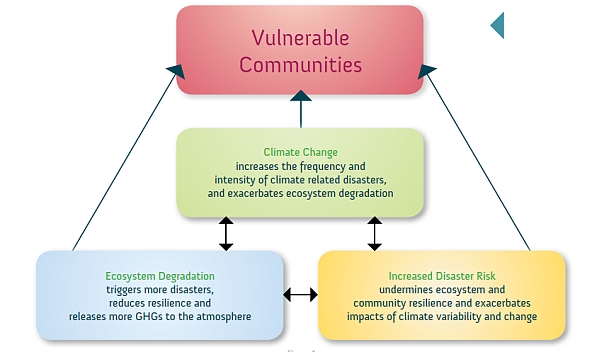
Figure 12. The interaction between climate change, ecosystem
degradation and disaster risk
(Source: UNEP, 2009)
Adaptation to climate change can be achieved to a large extent
through building sustainable and spatially enabled land administration
systems. This should enable control of access to land as well as control
of the use of land. Such integrated land administration systems should
include the perspective of possible future climate change and any
consequent natural disasters. The systems should identify all prone
areas subject to sea-level rise, drought, flooding, fires, etc. as well
as measures and regulations to prevent the impact of predicted climate
change.
Key policy issues to be addressed should relate to protecting the
citizens by avoiding concentration of population in vulnerable areas and
improving resilience of existing ecosystems to cope with the impact of
future climate change. Building codes may be essential in some areas to
avoid damage e.g. in relation to flooding and earthquakes. Issues may
also relate to plans for replacement existing settlements as an answer
to climate change impacts.
The measures of building integrated and spatially enabled land
information systems does not necessarily relate to the inequity between
the developed and less developed countries. Implementation of such
systems will benefit all countries throughout the globe. Therefore, the
integrated land administration systems should, in addition to
appropriate registration of land tenure and cadastral geometry, include
additional information that is required about environmental rating of
buildings, energy use, and current and potential land use related to
carbon stock potential and greenhouse gases emissions.
This also relates to the fact that climate change is not a
geographical local problem that can be solved by local or regional
efforts alone. To address climate change, international efforts must
integrate with local, national, and regional abilities.
Urbanisation is another major change that is taking place globally.
The urban global tipping point was reached in 2007 when over half of the
world’s population was living in urban areas; around 3.3 billion people.
This incredibly rapid growth of megacities (more than 10 million
inhabitants) causes severe ecological, economic and social problems. It
is increasingly difficult to manage this growth in a sustainable way. It
is recognised that over 70% of the growth currently happens outside of
the formal planning process and that 30% of urban populations in
developing countries living in slums or informal settlements, i.e. where
vacant state-owned or private land is occupied illegally and used for
illegal slum housing. In sub-Saharan Africa, 90% of all new urban
settlements are taking the form of slums. These are especially
vulnerable to climate change impacts as they are usually built on
hazardous sites in high-risk locations. Even in developed countries
unplanned or informal urban development is a major issue (FIG/WB 2010).
Urbanisation is also having a very significant impact on climate
change. The 20 largest cities consume 80% of the world’s energy use and
urban areas generate 80% of greenhouse gas emissions world-wide. Cities
are where climate change measures will either succeed or fail.
Rapid urbanisation is setting the greatest test for Land
Professionals in the application of land governance to support and
achieve the MDGs. The challenge is to deal with the social, economic and
environment consequences of this development through more effective and
comprehensive spatial and urban planning, resolving issues such as the
resulting climate change, insecurity, energy scarcity, environmental
pollution, infrastructure chaos and extreme poverty.
In conclusion, the linkage between urban growth, climate change
adaptation, and sustainable development should be self-evident. Measures
to manage urban growth and for adaptation to climate change will need to
be integrated into strategies for poverty reduction to ensure
sustainable development. The land management perspective and the role of
the operational component of land administration systems therefore need
high-level political support and recognition.
8. THE ROLE OF LAND PROFESSIONALS AND FIG
The role surveyors are changing. In a global perspective there is a
big swing that could be entitled “From Measurement to Management”. This
does not imply that measurement is no longer a relevant discipline to
surveying. The change is mainly in response to technology development.
Collection of data is now easier, while assessment, interpretation and
management of data still require highly skilled professionals. The role
is changing into managing the measurements. There is wisdom in the
saying that “All good coordination begins with good coordinates” and the
surveyors are the key providers.
The concept of a modern Positioning Infrastructure (combining
satellites and reference stations on the ground) still supports the
activities traditionally associated with a geodetic datum but extends
toward much broader roles on the global scale. It can be argued that
GNSS could be considered one of the only true global infrastructures in
that the base level of quality and accessibility is constant across the
globe (Higgins, 2009). Such a Positioning Infrastructure moves the focus
from measurement of framework points to management of the data received
from the positioning system.
The change from measurement to management also means that surveyors
increasingly contribute to building sustainable societies as experts in
managing land and properties. The surveyors play a key role in
supporting an efficient land market and also effective land-use
management. These functions underpin development and innovation for
social justice, economic growth, and environmental sustainability. The
big swing is implies a change from land surveyors to land professionals.
FIG is an UN recognised NGO representing the surveying profession in
about 100 countries throughout the world. FIG has adopted an overall
theme for the current period of office (2007-2010) entitled “Building
the Capacity”. This theme applies to the need for capacity building in
developing countries to meet the challenges of fighting poverty and
developing a basis for a sustainable future, and, at the same time,
capacity is needed in developed countries to meet the challenges of the
future in terms of institutional and organisational development in the
areas of surveying and land administration.
In general, FIG will strive to enhance the global standing of the
profession through both education and practice, increase political
relations both at national and international level, help eradicating
poverty, promote democratisation, and facilitate economic, social and
environmental sustainability. FIG can facilitate support of capacity
development in three ways:
- Professional development: FIG provides a global forum for
discussion and exchange of experiences and new developments between
member countries and between individual professionals in the broad
areas of surveying and mapping, spatial information management, and
land management. This relates to the FIG annual conferences, the FIG
regional conferences, and the work of the ten technical commissions
within their working groups and commission seminars. This global
forum offers opportunities to take part in the development of many
aspects of surveying practice and the various disciplines including
ethics, standards, education and training, and a whole range of
professional areas.
- Institutional development: FIG supports building the
capacity of national mapping and cadastral agencies, national
surveying associations and survey companies to meet the challenges
of the future. FIG also provides institutional support to individual
member countries or regions with regard to developing the basic
capacity in terms of educational programs and professional
organisations. The professional organisations must include the basic
mechanisms for professional development including standards, ethics
and professional code of conduct for serving the clients.
- Global development: FIG also provides a global forum for
institutional development through cooperation with international
NGO´s such as the United Nations Agencies (UNDP, UNEP, FAO,
HABITAT), the World Bank, and sister organisations (GSDI, IAG, ICA,
IHO, and ISPRS). The cooperation includes a whole range of
activities such as joint projects (e.g. The Bathurst Declaration,
The Aguascalientes Statement), and joint policy making e.g. through
round tables. This should lead to joint efforts of addressing
topical issues on the international political agenda, such as
reduction of poverty and enforcement of sustainable development.
FIG, this way, intends to play a strong role in improving the
capacity to design, build and manage surveying and land management
systems that incorporate sustainable land policies and efficient spatial
data infrastructures. These systems should also respond to the global
agenda in terms of the Millennium Development Goals and the new key
challenges in terms of climate change, natural disasters, and urban
growth.
9. FINAL REMARKS
Cadastral Systems underpin efficient management of the four key
functions within the land management paradigm. And the large scale
cadastral map is a key tool in providing the representation of the human
scale of land use and how people are connected to their land. The role
of cadastral systems has evolved over time from primarily serving as a
basis for land taxation and/or security of land tenure towards being the
key driver for achieving good governance of land and natural resources
in support of national policies and the global agenda.
Over the last decades FIG and the global surveying community has
taken a leading role in driving this evolution. Sound land governance is
the key to achieve sustainable development and to support the global
agenda set by adoption of the Millennium Development Goals.
FIG, this way, is building the capacity for taking the land policy
agenda forward in a partnership with the UN agencies and the World Bank.
This is documented in recent publications such as: “Land Governance in
Support of the Global Agenda” (FIG/WB, 2010) and “Innovations in Land
Rights Recognition, Administration and Governance” (WB/GLTN/FIG/FAO
(2010).
REFERENCES
Communities and Local Government (2008): Place matters: the Location
Strategy for the United Kingdom.
http://www.communities.gov.uk/publications/communities/locationstrategy
De Soto, H. (1993): The Missing Ingredient. The Economist, September
1993, pp. 8-10.
Enemark, S. (2004): Building Land Information Policies, Proceedings
of Special Forum on Building Land Information Policies in the Americas,
26-27 October 2004, Aguascalientes, Mexico.
http://www.fig.net/pub/mexico/papers_eng/ts2_enemark_eng.pdf
Enemark, S. (2006): People, Politics, and Places – responding to the
Millennium Development Goals. Proceedings of international conference on
Land Policies & legal Empowerment of the Poor. World Bank, Washington,
2-3- November 2006.
http://www.fig.net/council/enemark_papers/2006/wb_workshop_enemark_nov_2006_paper.pdf
Enemark, S. (2009): Spatial Enablement and the Response to Climate
Change and the Millennium Development Goals. Proceedings of the 18th UN
Regional Cartographic Conference for Asia and the Pacific, Bangkok,
26-30 October 2009.
http://unstats.un.org/unsd/METHODS/CARTOG/Asia_and_Pacific/18/18th-UNRCC-AP-Docs.htm
FAO (2007): Good Governance in Land Tenure and Administration, FAO
Land Tenure Series no 9. Rome.
ftp://ftp.fao.org/docrep/fao/010/a1179e/a1179e00.pdf
FIG Publications, FIG Office, Copenhagen, Denmark.
http://www.fig.net/pub/figpub/index.htm
FIG/WB (2010): Land Governance in Support of the Millennium
Development Goals. FIG Publication no 45, FIG Office, Copenhagen.
http://www.fig.net/pub/figpub/pub45/figpub45.htm
Higgins, M. (2009): Positioning Infrastructures for sustainable Land
Governance. Proceedings of FIG/WB Conference on Land Governance in
Support of the MDGs, Washington, 9-10 March 2009.
http://www.fig.net/pub/fig_wb_2009/papers/sys/sys_1_higgins.pdf
Steudler, D., Williamson, I., Rajabifard, A., and Enemark, S. (2004):
The Cadastral Template Project. Proceedings of FIG Working Week 2004,
Athens, 22-27 May. 15 p.
http://www.fig.net/pub/athens/papers/ts01/ts01_2_steudler_et_al.pdf
United Nations (2000): United Nations Millennium Declaration.
Millennium Summit, New York, 6-8 September 2000, New York.
http://www.un.org/millennium/declaration/ares552e.pdf
UN-ECE (1996): Land Administration Guidelines with Special Reference
to Countries in Transition, United Nations Economic Commission for
Europe ECE/HBP/96, New York and Geneva, 112p.
http://www.ica.coop/house/part-2-chapt4-ece-landadmin.pdf
UN-ECE (2005): Land Administration in the UNECE Region: Development
trends and main principles.
http://www.unece.org/env/documents/2005/wpla/ECE-HBP-140-e.pdf
UNEP (2009): The Role of Ecosystem management in Climate Change
Adaptation and Disaster Risk Reduction. Copenhagen Discussion Series.
http://www.unep.org/climatechange/LinkClick.aspx?fileticket=rPyahT90aL4%3d&tabid=129&language=en-US
UN-HABITAT (2003): Handbook on Best practices, Security of Tenure and
Access to Land. ISBN: 92-1-131446-1. UN-Habitat, Nairobi.
http://www.unhabitat.org/pmss/getPage.asp?page=bookView&book=1587
UN-HABITAT (2008): Secure Land Rights for all. UN Habitat, Global
Land Tools Network.
http://www.gltn.net/en/e-library/land-rights-and-records/secure-land-rights-for-all/details.html
WB/GLTN/GLTN/FAO (2010): Innovations in Land Rights Recognition,
Administration and Governance”. World Bank, Washington D.C.
http://siteresources.worldbank.org/INTARD/Resources/335807-1174581646324/InnovLandRightsRecog.pdf
Williamson, I. and L. Ting (1999): Cadastral Trends. Proceedings of
FIG Commission 7, FIG Working Week, Sun City, South Africa, June 1999,
pp. 1-19.
Williamson, I.P. (2010): Wrap-up keynote, GSDI World Conference,
Singapore, 19-22 October 2010.
http://www.gsdi.org/gsdiconf/gsdi12/slides/P5c.pdf
Williamson, I.P., Enemark, S., Wallace, J. and Rajabifard, A. (2010):
Land Administration for Sustainable Development. ESRI Press Academic,
Redlands, California. USA. 497 pages. ISBN 978-1-58948-041-4. For
information, see:
http://www.fig.net/news/news_shortstories.htm
BIOGRAPHICAL NOTES
Stig Enemark is President of the International Federation of
Surveyors, FIG 2007-2010. He is Professor in Land Management and Problem
Based Learning at Aalborg University, Denmark, where he was Head of
School of Surveying and Planning 1991-2005. He is a well-known
international expert in the areas of land administration systems, land
management and spatial planning, and related educational and capacity
building issues. He has published widely in these areas and undertaken
consultancies for the World Bank and the European Union in a range of
countries in Asia, Eastern Europe, and Sub Saharan Africa.
CONTACTS
Prof. Stig Enemark
FIG President 2007-2010
Department of Development and Planning,
Aalborg University
11 Fibigerstrede
9220 Aalborg
DENMARK
Email: enemark@land.aau.dk
Website:
http://www.fig.net/council/president_enemark.htm
 |


