Article of the Month - September 2019
|
The Development of National Atlas – Malaysia’s
Experience
Nur Zurairah Abdul Halim, Zoher Nomanbhoy and
Mohd Noor ISA, Malaysia
 |
 |
 |
|
Nur Zurairah Abdul Halim |
Zoher Nomanbhoy |
Mohd Noor ISA |
This article in .pdf-format
(17 pages)
This article is a peer reviewed paper presented at
the FIG Working Week 2019 in Vietnam.This paper has provided
explanations on the components of Malaysia’s national atlas, the
methodology, issues and recommendations, as well as future works.
SUMMARY
A national atlas is an essential multi-subject geographic atlas of a
country. It is a widely known cartographic product which contains the
summary representation of contemporary scientific knowledge of the
country in the field of physical, economic and political geography. The
conception of a national atlas is a complex and no trivial matter.
Nevertheless, a national atlas is deemed necessary for infrastructural
planning, pre-investment studies and as a source for geospatial
information transfer that enables international comparability. On top of
that, it is a symbol of national unity, scientific achievement, and
political independence. Realising its importance, the new National Atlas
of Malaysia project was initiated in mid-2014 and later completed then
published in late-2016. This paper aims to share the experience of
developing the National Atlas of Malaysia. The methodology of designing
the national atlas is explained, while issues and recommendations from
Malaysia’s perspective are also highlighted. The ongoing progress of
updating the national atlas is also deliberated to ensure the relevancy
of the national atlas to the public. By publishing the national atlas,
the dissemination of popularised but authoritative scientific
information about the geography of Malaysia from a national perspective
can be achieved.
1. INTRODUCTION
1.1 Atlas
Before the 19th century, atlases were made as a reference, mainly to
show the discoveries and conquest of the Europeans. Today, an atlas is a
collection of thematic maps designed to be kept in volume, showing the
spatial distribution of phenomenon and contain a substantial of spatial
and attribute data that are displayed as maps. Non-map elements like
text and graphics are also embedded to amplify information transfer.
Nonetheless, it should be noted that an atlas is not just a random
collection of maps but the result of a systematic approach, with a
specific narrative that provides cohesion to every themed map (Blok &
Versloot, 1993). The elements of cartographic including choice of
scales, levels of generalisations and labelling are applied in atlases
to allow the ‘readers’ to understand the coherence of the spatial
characteristics and information of an area or a theme. The advantage of
having atlases rather than a map is because atlases allow easy
comparisons of themes, space and time over the individual map (Aditya &
Kraak, 2006). As a result, maps in atlases are handy in the early
inventory stages of planning and decision making, as information sources
for politicians, legislators, administrators and planners.
1.2 National Atlas
One can distinguish among many different atlases. For example,
reference, school, topographic, national, and thematic atlases (Kraak,
2006). This paper emphases on the national atlas. National and regional
atlases have common origins, but as Nicholson (1970) points out, "true
regional atlases are not usually national atlases in miniature". A
national atlas shows as entirely as possible spatially relevant data
about the nation but in a way that comparison is possible. It contains
in summary representation of contemporary scientific knowledge of the
country in the field of physical, economic and political geography.
Materials from a wide range of sources commonly from institutes, bureaus
and governmental organisations that generally are not accessible are
made available to the public.
The making of national atlas began with the increasing demand for
quality and quantity of spatial science in the 19th century. As more
countries gained independence in the following century, a national atlas
was deemed necessary as an inventory of spatial information of a
country, to describe the characteristics of a nation, scientific
inventory to initiate new research or investment and cultural ambassador
to present the country (Bakker, van Elzakker, & Ormeling, 1987). It is
also a substantial source for geospatial information transfer that
enables international comparability. On top of that, Monmonier (1994)
added, it is a symbol of national unity, scientific achievement, and
political independence. From the perspective of education, a national
atlas is useful as a comprehensive single and reliable reference source
of spatial information among students. The national atlas may also be
useful in stimulating an appreciation of national identity and can be
regarded as a kind of cultural ambassador, or for public relations so
the knowledge gap pertaining to the nation can be bridged among the
public, tourist, investors, researchers or developers. Nonetheless, the
aims of every national atlas are arbitrary and highly influenced by
nationalistic ideology (Blok & Versloot, 1993).
1.3 Components of a National Atlas
Traditionally national atlases are available in books, but with the
advent of the internet and GIS, national atlas are also available in
digital forms or interactive maps. The first recognised 'modern'
national atlas, the Atlas of Finland, was published in 1899. A departure
from previously produced atlases, it "presented in a very concise,
economical and clear manner a tremendous variety of information on the
physical environment, population and economy of the entire country"
(Fremlin & Sebert, 1972). Fifty-seven years later, an International
Commission on National Atlases was set up by Professor K.A.
Salichtchev, who was an Honorary Fellow of the International
Cartographic Association, to review and recommend national atlases
design and content in order to ease the usability of the national atlas
(Ormeling Sr, 1979). The recommendations included:
- The content is separated into five structured divisions,
physical geography, population, economy, cultural, and political and
administrative structure, usually with an introductory section
preceding the content specifications.
- Methods of representing phenomena with different types of
distribution: at points, along lines, in discrete areas, sparse and
continuous across the area.
- Use of a simple, rounded [standardised] scale of 1:1,000,000, by
which all other scales can be related (doubling or halving). An
ideal format should be 40-50 cm by 60-70 cm when opened.
- A single projection for all maps should be used, with a
fundamental aim to restrict distortions; for the world's largest
countries, recommendations are made on the appropriate projection to
be used.
- Graticules should appear but not emphasised on all maps, except
in “map diagrams”: choropleths, “maps-with-graphs”, inset maps or
“social topic” maps.
In reference to the above, Kent (1986) also highlighted that there
are three components to distinguish a national atlas:
- It must be produced with the approval of the national
government;
- The goal is to provide a broad and accessible thematic coverage
of one nation, and
- Must be produced at a high intellectual and cartographic
standard.
In other words, even if the thematic coverage of a nation is broadly
covered, but the atlas is privately authored and published, nor a
complete thematic coverage of a nation had been prepared by the
government’s aegis, but the atlas is restricted and inaccessible, then,
the both of them would still not be considered a national atlas.
2. NATIONAL ATLAS FOR MALAYSIA
Malaysia’s first national atlas was published in 1977. It was
developed based on the recommendations highlighted by the International
Commission on National Atlases. However, like most countries with
national atlases, Malaysia also faced the same difficulty as the rest,
which is to manage newly updated edition within, i) a specific time
intervals; ii) limited financial source and iii) extensive labour. As a
result, the proposal to update the national atlas was finally approved
by the National Spatial Data Mapping Committee or also known as JPDSN in
1994. Following the consensus, works on developing the National Atlas
Information System (NAIS) was initiated and was realised in 1999, with
the aim to establish a fundamental database for the creation of an
updated national atlas and electronic map publishing. The basis of
distinguishing a national atlas as highlighted by Robert (1986) was
highly noted in the preparation of the national atlas.
The first electronic Map or eMap was published in 2001, which covered
Federal Territory Kuala Lumpur and Putrajaya. Consequently, every state
in Malaysia was prepared with eMaps, but with limited themed maps.
Subsequently, the advent of web map services during the course of the
Web2.0 revolution allowed the introduction of WebMap in 2002. Even
though most of the maps in eMaps or WebMaps only covered political and
physical map themes, the maps have played a significant role in
transferring geospatial and statistical information to users in an
interactive multimedia cartographic form. It was agreed that a coherent
but a variety of themed maps are desired to produce a national atlas -
the inevitable systematic publication of institutionally collected
geospatial information to enable a partial or total synthesis to be
made.
Therefore, the National Atlas Technical Committee (NATC) that
comprises various members from governmental agencies and data custodians
was subsequently formed in 2010, under the purview of JPDSN and
spearheaded by the Cartographic and GIS Division, Department of Survey
and Mapping Malaysia (JUPEM). The members were carefully selected to
ensure the authenticity of the information provided in the national
atlas. NATC aimed to coordinate and ease data sharing and descriptive
information of specific themed maps, aside to monitoring the working
progress of publishing a new and replacing the former national atlas
according to the specified themes by the relevant working groups.
Five working groups were established based on the five structured
divisions recommended by Salichtchev's were adopted as shown in Table 1,
to implement the atlas information gathering. However, as the project
progresses, additional relevant themes were identified and adjusted to
suit with Malaysia’s context as shown in Table 2. Working group chairs
were appointed to lead each theme. The Working Groups were responsible
for grouping, class and range the atlas according to its designated
themes based on vector data of 1:500,000 scale, in the form of various
GIS formats namely *.shp, *.tab or *.mdb. Apart from that, the working
groups were also responsible in preparing descriptive information such
as text, figures, schedules, images, audios and videos related to the
themes specified in the form of Words, *.jpg, *.avi and others.
Ultimately, 10 themes were finalised, and 49 sub-themes were identified
to form the national atlas.
| Working Groups |
Theme |
Members |
| 1 |
Introduction, History, Boundaries,
Climate and Physical |
Department of Survey and Mapping Malaysia (Chairman)
Department of Land and Survey Sabah
Department of Land and Survey Sarawak Geospatial Defence
Division, DSMM Institute of Language and Literature (DBP) |
| 2 |
Natural Resources and Land Use |
Department of Agriculture, Malaysia (Chairman)
Department of Agriculture, Sabah
Department of Agriculture, Sarawak
Department of Forestry, Peninsular Malaysia
Department of Forestry, Sabah
Department of Forestry, Sarawak
Department of Mineral and Geoscience, Malaysia Remote Sensing
Agency Malaysia |
| 3 |
Infrastructure and Public Amenities |
Department of Works, Malaysia (Chairman)
Federal Department of Town and City Planning, Peninsular
Malaysia Department of Town and City Planning, Sabah
Department of Land and Survey Sarawak Ministry of Education |
| 4 |
Socioeconomic |
Department of Statistics Malaysia
(Chairman)
Department of Geography, Faculty of Literature and Social
Science, University Malaya,
Department of Orang Asli Development |
| 5 |
Tourism |
Tourism Malaysia (Chairman) Department of Survey and Mapping
Malaysia |
Table 1: Working Group Members According to
Themes
1.1 National Atlas Malaysia’s Themes
Unlike most common national atlases, that comprises general themes
such as Climate, Physical, Natural Resources, Infrastructure and
Politics, additional themes were added into Malaysia’s National Atlas,
namely History, Socioeconomic and Tourism (JUPEM, 2016). Additional
themes were added in hopes that the national atlas will attract a more
extensive user, particularly in secondary and tertiary levels of
education, and also interest the public apart from those involved
directly with geospatial analysis or planning. According to Blok and
Versloot (1993), the practice is common, and it is well understood that
most national atlas is developed to suit national requirement. In
totality, 10 themes and 49 sub-themes were being developed for the
national atlas as shown in Table 2. These themes are complemented with
current maps, descriptive information, validated statistical graphics
and infographics to provide exciting narrative to the users.
The descriptions of the themes in Table 2 are as follows:
2.1.1 Introduction
The atlas is introduced by firstly displaying the world maps of
locality, politics, time and population which then followed by the same
map themes on Asia’s continent, Southeast Asia region and finally
Malaysia. More detailed information of the themes can be grasped in
large-scale maps of the states in Malaysia.
| No |
Theme |
Sub-Theme
|
| 1 |
Introduction |
World Physical
World Politics
World Time Zone
Population
Continent
Asia
South East Asia
Malaysia
States |
| 2 |
History |
Malaysia across time
World Heritage Sites
National Heritage Sites
Conservations |
| 3 |
Boundaries |
International and state boundaries
District, Mukim, City and Town Boundaries
Division and District Boundaries (East Malaysia) Federal
election boundaries State election boundaries |
| 4 |
Climate |
Department of Statistics Malaysia
(Chairman)
Department of Geography, Faculty of Literature and Social
Science, University Malaya,
Department of Orang Asli Development |
| 5 |
Physical |
Ranges
Mountains and Hills
Rivers and lakes |
| 6 |
Natural Resource |
Petroleum and natural gas
Metal-based minerals
Non-metal based mineral |
| 7 |
Land Use |
West Malaysia forest
West Malaysia crops
East Malaysia forest
East Malaysia crops
Urban |
| 8 |
Infrastructure and Public Amenities |
Educational Institute
Primary and secondary schools distribution
National Service Training Programs
Public and private hospitals
Sports and recreation
Transportation
Klang Valley transportation |
| 9 |
Socioeconomic |
Population density
Gender ratio
Senior citizen population
Youth population
Dependency ratio
West Malaysia aborigines
East Malaysia ethnics |
| 10 |
Tourism |
Ecotourism
North and East Coast Zone
Central and South Zone
East Malaysia Zone
Tourist destinations
Sabah Parks
Diving locations West Malaysia
Diving locations East Malaysia |
Table 2: Malaysia’s national atlas themes and
sub-themes
2.1.2 History
The History theme brings to a comprehensive approach concerning the
past. This theme is divided into 3 subthemes namely World Heritage
Sites, National Heritage Sites and Conservation Sites. World heritage
sites and national heritage sites indicate locations that have been
registered and recognised as heritage sites, while conservation refers
to places that are actively engaged in conservation activities. A sample
of the National Heritage Sites Sub-theme of the National Atlas is as
shown in Figure 1.
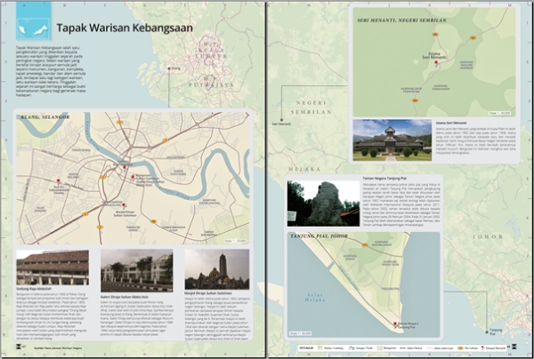
Figure 1: A sample of the National Heritage Sites Sub-Theme under the
History Theme of the National Atlas.
2.1.3 Boundary
This theme displays administrative boundaries that can also be shown
into two sub-themes of political and administrative boundaries.
Political boundaries describe the election borders, which refers to
parliamentary and constituency’s borders. The administrative boundaries
illustrate the multi-level administrative jurisdiction boundary of the
international, state, district and mukim boundaries.
2.1.4 Climate
Climate themes display climate-like concepts such as temperature and
rain. Climate factors do influence development in Malaysia from various
aspects including agriculture, industry, tourism and socio-economic.
This theme is divided into Temperature, Annual Rainfall, Humidity,
Evaporation and Solar Rays.
2.1.5 Physical
This theme provides the topographic information available in
Malaysia. Features like ranges, mountains, hills, rivers and lakes are
among the many that have been included in the theme to describe the
physical of Malaysia’s terrain and its potentials for sustainable land
development. A sample of the Rivers Sub-theme of the National Atlas is
as shown in Figure 2.
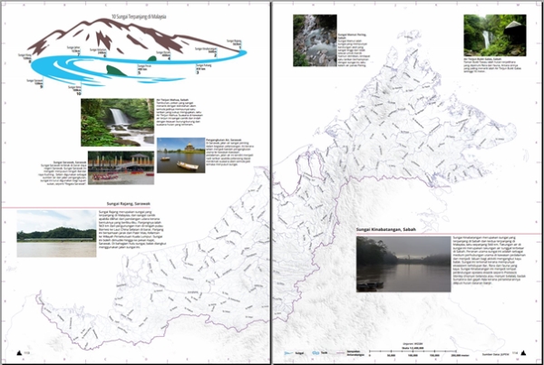
Figure 2: A sample of the Rivers Sub-theme under the Physical Theme
of the National Atlas.
2.1.6 Natural Resource
The Natural Resources theme gives a more specific look to the natural
resources available in Malaysia. Location for petroleum and natural gas
as well as other metal and non-metallic minerals are covered in this
theme. Each mineral available is shown differently, based on the colour
aspect, hardness, volume, chemical composition, lightning, melting
force, magnetic attraction etc. A sample of the Petroleum and Natural
Gas Sub-theme of the National Atlas is as shown in Figure 3.
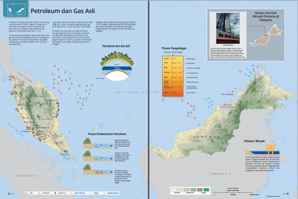
Figure 3: A sample of the Petroleum and Natural Gas Sub-Theme under
the Natural Resources Theme of the National Atlas.
2.1.7 Land Use
Land use is an activity of optimising land and its natural
surroundings into a place for settlement or other human activities.
Various types of land use also have a direct impact on the economy such
as commercial, industry, agriculture, and housing. This theme focuses on
land use activities such as forests, major crops and municipalities.
2.1.8 Infrastructure and Public Amenities
Infrastructure refers to basic facilities or services provided by the
authorities for the development community. This theme focuses on
education, health and transportation. For education, the location of
higher education institutes, polytechnics and schools are displayed
along with its descriptive information. Health displays the information
on health facilities such as the locality of hospitals as well as sports
and recreation amenities. While Transportation features land, water and
air transportation facilities.
2.1.9 Socioeconomic
Socioeconomics is a theme that translates community life from the
economic and social aspects of society. In this theme socioeconomic is
described through several subthemes such as Population Density, Gender
Ratio, Senior Citizen Population, Youth Population, Dependency Ratio,
Orang Asli Peninsular Malaysia as well as Sabah and Sarawak’s ethnic
groups. A sample of the Youth Population Sub-theme of the National Atlas
is as shown in Figure 4.
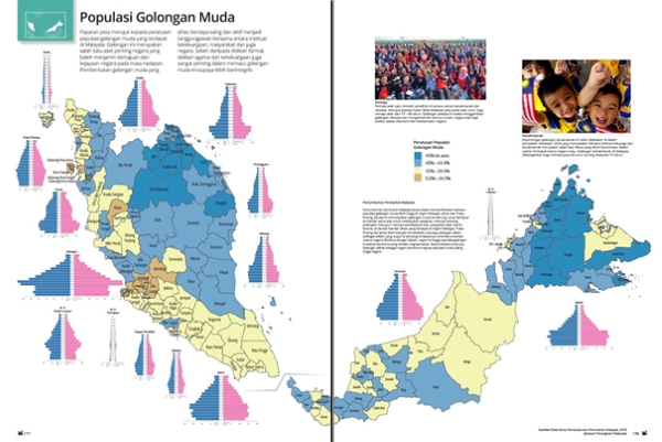
Figure 4: A sample of the Youth Population Sub-theme under the
Socioeconomic Theme within the National Atlas.
2.1.10 Tourism
This theme introduces Malaysia as tourist destinations for locals or
international travellers. The tropical climate of the country makes
Malaysia rich and diverse with tourist attractions. In this theme, the
location is displayed by tourist destinations by zone, Sabah Parks and
locations diving in Peninsular Malaysia and the State of Sabah.
3. METHODOLOGY
In general, Figure 1 depicts the process flow carried out in
developing Malaysia’s National Atlas. Since the first Malaysia’s
national atlas was published almost 30 years earlier, this new national
atlas still maintains the traditional atlas feel of an inventory and
descriptive atlases in nature.
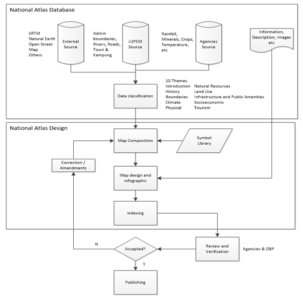
Figure 1: Malaysia’s National Atlas development process flow
Three types of data source were identified and recognised as JUPEM
Source (Internal), External Source and Agencies Source. For the JUPEM
Source database, the dataset utilised for the base map was originally
from the topographic medium scale database (1:50,000) that had been
generalised and converted into the small-scale topographic database
(1:500,000). The base map provides a uniform scale, projection and
layout, and thus optimal comparability of the maps. Administrative
boundaries, rivers, roads and names of cities, town and kampong, were
among the features and attributes accessible as the basis of the
national atlas dataset. Shuttle Radar Topography Mission (SRTM) vertical
information with 30m accuracy was recognised as one of the datasets from
External Source and became the basis for relief generation. Data and
descriptive information related to the relevant themes, such as climate,
land use and natural resources that were retrieved from the respectively
authorised data custodian, are samples of the many datasets available
from the Agencies Source database. All three main data source are
central to the development of the national atlas database. Aside from
that, the datasets collected were as much as possible to reflect the
most recent information for maximum usefulness and in order to allow
optimum comparison.
Once the development of the national atlas database was finalised,
the data classification process was conducted using the GeoMedia
application, where the datasets were classified to meet the 10
designated themes highlighted in section 2.1. Subsequently, the map
composition process was done with Adobe Illustrator and Avenza Map
Publisher with the relevant thematic symbols adopted from the system’s
symbol library. Next, the map layout and infographic designed for
publishing, using Adobe InDesign. The sequence of the maps was arranged
as centripetal. Users can explore the national atlas by starting from
the earth’s view as a whole, then zoom in to the world’s continents
view, followed by Asia, South East Asia and afterwards Malaysia as a
country and finally the fourteen states. These maps were edited and
redrawn to be presented at a similar level of generalisation and
hierarchical classification to allow comparison.
Writing materials comprising of statistical information, graphics and
images were also added in the process. Accompanying text makes the atlas
feels more like a book where one can read from one page with maps,
graphs and images to another, telling the story of the subject of the
theme designated. Innovative and engaging design were made to the
wide-ranging content to allow easy access and user-friendly atlas.
Considering that minor or major revisions of the national atlas do not
require any less work from the later, therefore, it is imperative for
the date of sources to be mentioned as near to the maps, so users are
aware of any outdated information. Chronological information, especially
to fluctuating dataset such as population, was added to guide users the
relative value of the displayed infographics.
Next, the index was created. The indexing for the national atlas
utilises the combination of geographical coordinates and alphanumerical
grids. The reason to adopting the combination was to cater more
experienced users to better understand the actual location of the map on
the globe and the real world, and to assist novice users to point the
specific location on the map based on the grid’s quadrant.
Consequently, the national atlas verification process was conducted
iteratively where all relevant parties including JUPEM, agencies and
data provider validate the atlas content either accepted for publishing,
amendments or omitted from the atlas. Since Malaysia’s National Atlas
was decided to be published in the national language, the final
assessment of the atlas was conducted by the Institute of Language and
Literature or locally known as Dewan Bahasa dan Pustaka to review words
and expressions used such as the vocabulary, terminology and standards.
Lastly, after almost 18 months, the national atlas was finalised and
published by JUPEM in the year 2016. A digital version of the national
atlas was also made available for readers and can be viewed via the
internet.
4. ISSUES AND RECOMMENDATIONS
In preparing the national atlas, some issues and challenges were
identified. Based on Malaysia’s own experience, recommendations are also
highlighted in this section.
4.1 Data
A national atlas brings together materials from a wide range of
sources and makes them available to the public. The data format received
and compiled from the various agencies were of different formats (*.shp,
*.dwg, *.dgn, *.csv, etc.) and the metadata was incomplete of relevant
information such as datum and map projections. As a result, the data
transformation and conversion process were tedious and comprised some
trials and errors. Metadata should be set as compulsory to all data
providers to enable smooth data conversions.
4.2 Map Scale
Malaysia comprises of East and West Malaysia. The physical separation
of both regions by the South China Sea required the map layout to be
extended further and published in an odd format, for a uniform and
optimal scale to be applied for the national atlas. The situation is
unavoidable. Therefore, consideration should be made for choosing map
scale that includes the purpose of the maps, the complexity of the
mapped area, extension and size of the mapped area, sheet format,
importance of the mapped area to the users and the ability to allow map
comparison. Some flexibility can be attained and applied in making the
national atlas by using half pages, quarter pages, double pages, and
landscape or portrait orientation of maps.
4.3 Time constraint
The time given to complete the national atlas was only a year and was
hurried due to financial restraint. In spite of that, all 10 themes were
completed within the time frame. Typically, the time taken to complete a
national atlas by other countries was approximately three years.
Consideration, however, must be made to ensure the currentness of the
datasets if the time required for the completion of a national atlas is
too lengthy.
4.4 Research Group
Producing a national atlas can be considered a major scientific
project. A research group of experts on the relevant domains together
with the support of cartographers should be formed earlier to pilot the
preparation of the national atlas. The research group can assist the
NATC and its working groups by determining the significance of datasets
and its relationship, the data conversion processes and the suitability
of data and information to be mapped according to the identified themes.
Among the subjects that can be studied include identifying data
availability, compatibility and suitability, differences of data
classifications, map projections, the level of generalisations, optimal
scale and data currentness. The result of the study could find the gaps
in data and underline a more feasible and thorough process for the
project to prevent repetitively or out of context tasks during the
project implementation.
4.5 Heterogeneous data quality
Aside to different existing data formats, map projections and
incomplete information due to format conversion, some agencies datasets
were found irrelevant to the themes. Therefore, since time is of the
essence, the delay caused by the quality of data and the extra work for
data vetting, testing and editing have led to exhaustion of time and
resource specifically during the development of national atlas database
and map composition process. The lack of experts also contributed to the
delay of the vetting and editing process. To overcome this, a pilot
study on the data conducted by a research group could assist in
producing homogenous data quality. Apart from that, full time and
dedicated editor is desirable to oversee the data vetting and editing.
4.6 Lack of cooperation
The realisation of a national atlas is a complicated matter to ensure
accuracy, reliability and completeness. Therefore it requires
interdisciplinary cooperation among data providers, geospatial experts
and cartographers. Lack of cooperation and commitments among members are
undesirable. The action could hinder the improvement of a map
representation on a subject in a theme. Dedication should be instilled
to all members that the development of a national atlas is a national
pride and the quality of the atlas produced reflects the image of the
members and the country as well.
4.7 Language
Due to time restriction, the English version was not accounted in the
preparation of the national atlas. Therefore, foreigners may find
difficulty in reading the national atlas unless they understand the
national language; Bahasa Malaysia. Instead of a dedicated local and
English edition, the national atlas can be suggested to be published as
a bilingual version, particularly on the narrative texts, legends and
information. However, the move may result in other issues such as a
major revision to the infographic design and readjustment to the map
scale of the existing national atlas. Hence, a bilingual version may be
suitable and considered to countries who may for the first time produce
a national atlas or require a major revision of their current national
atlas.
4.8 Revision
It should be noted that the datasets utilised in the production of
Malaysia’s national atlas were collected at a specific period.
Therefore, outdated information is unavoidable upon the atlas
publication in 2016. It is suggested that fast-changing information
(fluctuating) be avoided in the national atlas. However, if it is
required, the representation of the data can be in a chronological form
to allow users to analyse the data trends and make their own conclusion
or future predictions. Unless a significant correction or amendment is
required, a cost-benefit ratio study is recommended to determine whether
the revision exercise is worth time, energy and resource. Nevertheless,
a specific time interval, i.e. every five years, may be suggested to
review the currentness of the national atlas.
5. NATIONAL ATLAS FUTURE WORKS
5.1 Interactive National Atlas
A digital version of Malaysia’s national atlas (e-book) is also
available, but further analysis or query could not be made to a flat
file format. At most, users can only peruse the atlas content.
Moreover, exposure to interactive maps such as Google Maps, on the
Internet encourages the map user to explore alternative methods of
representation that may lead to better map use skills and exploration.
Therefore, in meeting the revolution of Web 3.0 users who are easily
spatially enabled, an interactive national atlas for Malaysia is highly
desirable in the near future.
Consideration, however, should be made that the interactive national
atlas is to serve a large population of users, from the novice user to
the specialist researcher. Apart from that, previous researchers (Aditya
& Kraak, 2006; Fowler, 2005) have found that familiarity and simplicity
are essential to interactive atlas projects. According to their study,
users do not crave highly specific topics, and that maps showing
information based on complex calculations and excessive expert
interpretations do not interest the user. In addition to this, a study
conducted by Richmond and Keller, 2002 suggested that in developing
interactive maps (atlas), among the features that are in demand includes
should possess interactive capabilities like zooming in/out, hyperlinked
map to infographics or webpages, hyperlinked maps with other maps,
panning, flexible layers and animation. The advantage with interactive
and digital national atlas is incorrect and outdated maps, or
information can be amended and replaced easily. However, it should be
the intention for any future works of the national atlas to never lose
sight of the purpose of it being developed and for whom it was made. The
differences of a Geographic Information System and an Atlas Information
System should be understood by developers. Thus, interaction and
multimedia components should be managed carefully, so the emphasis is on
the visualisation of geographic information and cartographic
representation of the atlas, to assist users in developing visual
analysis, evaluation, interpretation and manipulation.
5.2 English Version National Atlas
As stated earlier in this paper, a national atlas can be a cultural
ambassador as well as a source for geospatial information transfer that
enables international comparability. Considering the English language is
a vibrant and international language, with most of the world's
population converse in it as either their first, second or third
language, an English version is deemed necessary to fulfil the purpose
of the national atlas (Blok & Versloot, 1993). Since the bilingual
version requires a major revamp of the existing edition, it was decided
an English version of the published 2016 Malaysia’s national atlas will
be prepared in the near future to cater the international audience.
6. CONCLUSION
This paper has provided explanations on the components of Malaysia’s
national atlas, the methodology, issues and recommendations, as well as
future works. It can be stressed from this atlas project that the
development of the national atlas was indeed a complex and no trivial
matter. Nevertheless, by publishing the national atlas, it is hoped the
dissemination of popularised but authoritative scientific information
about the geography of Malaysia from a national perspective can be
achieved. Apart from that, the purpose of the national atlas is also
seen inline in supporting the Sustainable Development Goal, where such
atlases can present, synthesise, analyse and explore the real world.
REFERENCES
Aditya, T., & Kraak, M.-J. (2006). Geospatial data infrastructure
portals: Using the national atlas as a metaphor. Cartographica: the
international journal for geographic information and geovisualization,
41(2), 115-134.
Bakker, N. J., van Elzakker, C. P., & Ormeling, F. (1987). National
atlases and development ITC-journal 1987-1, pp 83-92. ITC-journal, 1,
83-92.
Blok, C., & Versloot, A. (1993). Atlas Cartography. The Netherlands:
ITC, Enschede, The Netherlands.
Fowler, J. J. (2005). Toward a
web-based multimedia atlas of British Columbia. (Master of Science 148),
Memorial University of Newfoundland, New Foundland.
Fremlin, G., & Sebert, L. (1972). Historical Analysis Of National
Atlases. Cartographica: the international journal for geographic
information and geovisualization, 9(1), 1-29.
JUPEM. (2016). Atlas Kebangsaan Malaysia. Kuala Lumpur: Jabatan Ukur
dan Pemetaan Malaysia.
Kent, R. B. (1986). National Atlases: the Influence of Wealth and
Political Orientation on Content. Geography, 71(2), 122-130.
Kraak, M.-J. (2006). Why maps matter in GIScience. The Cartographic
Journal, 43(1), 82-89.
Monmonier, M. (1994). The rise of the national atlas. Cartographica:
the international journal for geographic information and
geovisualization, 31(1), 1-15.
Nicholson, N. (1970). Canada in Six Atlases. Cartographica: the
international journal for geographic information and geovisualization,
7(2), 126-130.
Ormeling Sr, F. (1979). The purpose and use of national atlases.
Cartographica: the international journal for geographic information and
geovisualization, 16(1), 11-23.
Robert, K. (1986). National atlases: The influence of wealth and
political orientation on content. Geography, 122-130.
Richmonde., & Kellerc, . P. (2002). Users' Comments on Maps and
Tourism Destination Marketing on the Internet. CART0 2002, Waterloo,
Ontario.
BIOGRAPHICAL NOTES
Nur Zurairah Abdul Halim and Zoher Nomanbhoy, both are at present
surveyors attached with the Cartographic & GIS Division, Department of
Survey and Mapping, Malaysia. They are currently reviewing the Malaysia
National Atlas, 2016 publication edition for revision and enhancement.
Mohd Noor Isa is currently the Director General of Mapping and Survey
Malaysia and has been holding the post since 2016. He
retired in May 2019


