Project BDI: the Socioeconomic Impact of
Comparable Property Analysis
through GIS 1
Cromwell MANALOTO, Daniele BRANCATO, Alessandro
DALMASSO, Luca DAL BUONO, Angelo CRESCENZI, Italy

Cromwell Manaloto
1)
The paper was presented at the FIG Commission 3 Workshop and Annual
Meeting in Iasi, Romania and was selected among the papers at the
workshop to be FIG Article of the Month. The article focuses on the BDI
– Real Estate Comparable Database Project, created to provide a
strategic tool to all entities operating in the real estate sector.
SUMMARY
The Banca del Dato Immobiliare (BDI – Real Estate Comparable
Database) is a project spearheaded by the College of Surveyors and
Graduate Surveyors of the Province of Ascoli Piceno developed in 2014.
The pilot project was created to provide a strategic tool to all
entities operating in the real estate sector, for example: as a market
analysis and asset management tool for enterprises; for Jurisdictional
authorities, the project would offer greater guaranty and transparency
on judicial sales and division while reducing eventual divergence
between the real estate value and price; for real estate valuers and
appraisers, it serves as an essential instrument in order to remain
compliant with the International Valuation Standards, Real Estate
Valuation Code by Tecnoborsa, the ABI Guidelines, the UNI 11558 and UNI
11612.
The BDI project was developed with the valuable and active
cooperation of the Order of Notaries Public of the Province of Ascoli
Piceno, with its members communicating a summary datasheet from every
deed of sale executed starting from the 1st of February 2014.
The elaborated data, which are potentially new “comparable property,”
are then inserted in the digital database. The BDI can therefore provide
precised geo-referenced and filtered data, optimized by “feature” or
characteristic of interest in order to favor faster and informed
decision making procedure thus, saving time and money.
This paper aims to illustrate the project, from the data acquisition
technique used, the archiving process and the planned GIS database using
the comparables previously gathered and stored. Moreover, this paper
will also look into the project’s socio-economic impact on one of its
macroterritory: Ascoli Capoluogo.
SUMMARY (Italian)
La Banca del Dato Immobiliare (BDI) è un progetto promosso dal
Collegio dei Geometri e Geometri Laureati della Provincia di Ascoli
Piceno.
Il progetto, primo in Italia, nasce con lo scopo di fornire uno
strumento strategico a tutti i soggetti che operano nell’ambito del
settore immobiliare, ad esempio: imprese della filiera immobiliare, per
le analisi di mercato e lo sviluppo di progetti Asset Management;
Organi Giurisdizionali, per ridurre drasticamente le divergenze tra
valori e prezzi offrendo maggiori garanzie e trasparenza nelle vendite
giudiziarie e nelle divisioni; professionisti Valutatori Immobiliari che
devono operare nel rispetto degli Standard Internazionali di Valutazione
e del Codice delle Valutazioni Immobiliari di Tecnoborsa, delle Linee
Guida ABI, della Norma UNI 11558 e della Norma UNI 11612.
Il progetto della BDI si sviluppa con la preziosa e fattiva
collaborazione dell’Ordine dei Notai della Provincia di Ascoli Piceno il
quale, attraverso i suoi iscritti, comunica i dati sintetici derivanti
dalla stipula di ogni compravendita a partire dal 1° febbraio 2014.
I dati, opportunamente “lavorati”, vengono poi inseriti in banca
dati. La BDI fornisce quindi ai soggetti che ne fanno richiesta la
possibilità di ottenere dati georeferenziati e filtrati, ottimizzati
allo scopo per le caratteristiche d’interesse al fine di operare le
proprie scelte con maggiore cognizione e rapidità e risparmio di tempo e
danaro.
Questa ricerca illustrerà il progetto stesso, dall’acquisizione dei
dati, l’inserimento dei dati raccolti ed il successivo progetto di
plottaggio su una mappa digitale in piattaforma GIS. La medesima ricerca
osserverà anche l’impatto socio-economico del progetto, soprattutto in
una delle proprie macroaree, ovvero della circoscrizione Capoluogo.
INTRODUCTION
The Banca del Dato Immobiliare differs from that of the government
digital cadastral database in terms of the ability of the technicians
that use the extracted data. The pragmatism of Italian surveyors, their
nature to be concretely technical and their ability to also exploit the
few and minimal information to get the best result, set up the necessary
flexibility to manage such a project in continuous evolution along with
other successive information.
The data properties that are needed for the purpose of estimating,
appraisals, and market analysis are few. Starting with a few readily
available data, a joint collaboration with the Provincial Order of
Notaries Public, and a few surveyors who have devoted much of their
time, it was possible to create a strategic tool fundamental for all
those who work within the real estate sector.
It is now a stable propensity of Italians to save, with deflationary
consequences resulting from the sharp drop in consumption.
Despite the recent strong global crisis, the current social-economic
situation is generated by the lack of availability to risk or at least,
to notice that there is more willingness to address them outside the
national borders. There is a clear lack of interest in investing in
Italy.
The reasons are many but certainly solvable but with the right
commitment from political resources and the availability of social
forces.
It is now established that investors, whether they are Italian or
foreign, need transparency, continuity, and socio-political trust.
Alternatively, an investment is carried out only with the inevitable
speculations.
The BDI project falls in our continuous commitment to transparency and
reliability.
THE PROJECT – The Beginning
In November 2014, the Tribune of Ascoli Piceno noted the importance
of utilizing a standardized estimation methodology. Other Provincial and
Regional Courthouses soon then followed such initiative, requiring of
the introduction of the said methodology in an expert’s report.
However, the Provincial College of Surveyors of Ascoli Piceno
decided, at least, to primarily limit the content of the database only
to the concept of "price" and therefore excluding temporarily the
concept of "value." In doing so, it was possible to temporarily and
greatly reduced the number of data (about a thousand). At the same time,
it was necessary to also focus on the reliability of the datum. With
that in mind, the valuable collaboration with the Order of Notaries
Public, who shared the project and who have also understood the
functional potentiality as a strategic market analysis tool.
Obviously, to get a sufficient amount of data needed to be able to
carry out UNI-compliant valuations, or to do market analysis, it would
have taken at least six months or so of data collection. The
College of Surveyors of Ascoli knew of the extraneous amount of sourcing
to proceed with the project but was sure that the efforts would be worth
it.
Only when real estate appraisals will be conducted in the Standards,
and are in compliance with UNI, the inclusion in the database of the
"value" could be undertaken. This is to ensure more points of comparison
and to fully understand the divergence between market values and market
prices.
THE PROJECT - Real Estate Transfers: Memorandum of Understanding
between Notaries Public and Surveyors
On the 11th of December 2014, in Rome, a Memorandum of Understanding was
signed between the President of the National Council of Notaries Public,
Maurizio D'Errico, and the President of the National Council of
Surveyors and Graduate Surveyors, Maurizio Savoncelli, to start a
collaboration between the two categories, aimed at making the
proceedings of land transactions in line with the highest safety
standard for town planning and building profile.
The agreement provides disclosure of real estate transfers integrated
with an optional technical report, drawn up by a surveyor. The said
document should demonstrate cadastral due diligence, and a construction
and urban analysis. On this day, the notary is able to ensure an
absolutely safe transfer in terms of marketability of real estate.
Thanks to this technical report - written in behalf of the seller, and
determines specific indications and requests from the notary - as much
security will be guaranteed even under the technical examination profile
on the building’s conformity.
In this way, every party involved in the negotiations will have the
certainty of the conformity of the building, at the same time, it lowers
the incidence of litigation and administrative procedures for
unconformity amnesty.
To enhance the skills, to stimulate the development of their activities,
and to promote initiatives inspired by the collaboration between the
technical professions, are the principles that inspired the birth of
this Memorandum of Understanding that the National Council of Surveyors
and Graduate Surveyors agrees to uphold. It also wishes to expand access
to other technical professions access to this database.
Imagine how any company that has an interest in developing any
investment from the smallest to the largest, can obviously be interested
to contain the risks involved, especially in cyclical times of market
dealings.
Investment analysis is based on a huge amount of data and numbers:
prices, values, costs, time, size, types, locations, demographic
prospects, urban perspectives, environmental and socio-economic issues.
Similarly, the Real Estate Appraisers, who are about 500,000 people
sparsed on the national territory, will have to deal with the
irreversible process of professionalization, adapting to the norms set
by International Standards. The Real Estate Appraisers also have
essential need of reliable data to compare and to capitalize in
compliance with UNI 11558, and UNI will soon be passed and will be in
line with Market Value Approach of the Project UNI U98000240. Today,
over 75% of credit institutions which already operating under the
restrictive rules of AQR (Asset Quality Review), require their
“consultants” to possess at least, the ISO17024 certification by
February 2016, and to follow the A.B.I. Guidelines for Business Lending
Valuations. The interest then may have very important implications for
Court procedures and Civil Cognition Process.
First, there is opportunity to provide the adequate transparency by
demonstrating a real estate’s Market Value as defined int art. 4 par. 1
letter. 76 of Regulation no. 575/2013 - Capital Requirement Regulation,
thus justifying the succeeding base bid price. This ensures the debtor a
more responsive valuation of the property with the possibility of
eliminating speculation. On the other hand, this gives the creditor a
quicker solution to the Procedure; Finally, it provides security based
on a weighted investment derived from certain necessary data.
For the Cognition Process, it is of paramount importance to ensure the
certainty of value for both parties in the event of court divisions,
revocation, and in any other situation which requires transparency and
demonstrable results.
THE PROJECT – Timeline, Project Design and Data Collection
 |
The BDI project is developed with the active cooperation of the Order
of Notaries Public of the Province of Ascoli Piceno, which, through its
members and affiliates, report a synthetic report from every deed or
title transfer from the 1st February 2015. The data, suitably
"processed", are then inserted in the database using a pre-existing
database schema from a Stimatrix City, a known valuation software in
Italy. The BDI therefore provides persons who request the opportunity to
obtain geo-referenced and filtered data, optimized in order of
characteristic of interest, resulting to a more informed and faster
comparable searching and decision, so saving time and money.
The project, which became fully operational and usable from the 11th
December 2015, is integrated with complete sets of data usage and
instructions readily available from the Provincial College of Surveyors
of Ascoli Piceno’s webpage. Monthly developments are published regularly
that allows analysis of multiple segments in each municipal area.
|
BDI covers the entire province of Ascoli Piceno, which is
composed of 33 municipalities. Subsequently, all municipalities are
grouped and divided in six macro-areas, each controlled and monitored by
a Coordinator.
The Coordinator of the Macro-area, oversees the management and
collection of property data conferred by “technicians” verifying the
correctness and completeness prior to data entry process in the
database. The Coordinator monitors the area to detect any useful detail
to identify or study recent the market trend/s, on new construction
and/or renovation.
The macro-areas are:
ZONA CAPOLUOGO: Ascoli Piceno, Folignano, Maltignano;
ZONA MONTANA: Acquasanta Terme, Arquata del Tronto, Montegallo,
Montemonaco, Palmiano, Roccafluvione, Venarotta;
ZONA COLLINARE: Carassai, Castignano, Comunanza, Cossignano, Force,
Montalto delle Marche, Montedinove, Offida, Rotella;
ZONA VALLATA: Appignano del Tronto, Castel di Lama, Castorano, Colli del
Tronto, Monsampolo del Tronto, Spinetoli;
ZONA MARE SUD: Acquaviva Picena, Monteprandone, San Benedetto del
Tronto;
ZONA MARE NORD: Cupra Marittima, Grottammare, Massignano, Montefiori
dell’Aso, Ripatransone;
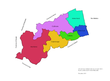
Immagine 2 Competenza territoriale di ogni macroarea del BDI
As of October 2016, over 2100 data or “comparables” are inserted in
the BDI database, with time range between February 2015 to June 2016.
Data gathered on 2016’s third quarter are still undergoing validation
and rectification. Figure 1 shows the Data collection results in the
first one and a half year of the project.
Each validated deed or title transfer are transcribed to a “comparable
module” (on paper form or an excel sheet) handed by each coordinator.
The format was designed to give emphasis to the specific characteristics
that are essential for valuation purposes.
Each “characteristic” from the module, once inserted on the Stimatrix
City’s database, are transformed automatically into features of the
integrated GIS of the software. Furthermore, the cadastral data of each
real estate subject of the deed, allows the GIS operator to
geo-referenced or allocate the real estate precisely on the map. In rare
occasion, when the module was completed with errors, further research on
the exact building location is conducted.
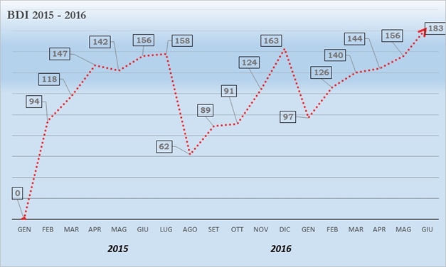
Figura SEQ Figura \* ARABIC 1: Andamento temporale di inserimento dei
comparabili tratti da recenti compravendita archiviati nel BDI fra
febbraio 2015 e giugno 2016.
DATA ANALYSIS, RECOMMENDATIONS AND CONCLUSION
Out of the 2190 data archived in the BDI database, around 2072 are
extracted which are from the Province of Ascoli Piceno. The other data
reported and sourced were from the nearby provinces of Teramo, Fermo and
Macerata (Image 2). Among the various real estate destination,
residential buildings were the most contracted type with 1344 deeds
registered, followed by Building Accessory (Pertinenziale) and lastly,
Agricultural lands.
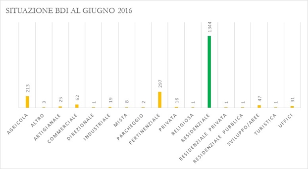
Figura SEQ Figura \* ARABIC 2 Situazione BDI al Giugno 2016 per
Destinazione Registrata dell’Immobile
The data shows that despite the fact that the Capoluogo hosts the
provincial capital, Ascoli Piceno, the Macroarea of Mare Sud seems to be
more active with real estate transactions, surpassing the Capoluogo by
37.8% in 17 months of the Project. This trend seems to be consistent
both in 2015 and 2016. The Municipality of San Benedetto del Tronto
seems to have a slightly more active real estate market despite having a
smaller area. Further analysis seems to indicate that the reason for
this trend is because of the geographical location of San Benedetto del
Tronto (seaside) and the abundant number of medium to high rise
condominium.
On the other hand, small Italian borghi have a limited amount of data
reported, thus, it could be hypothesized that they have limited
demographic movement.
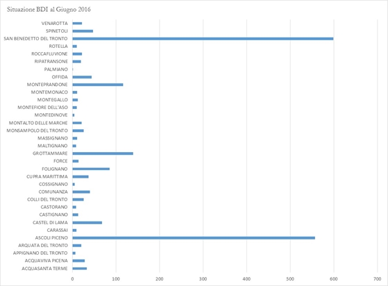
Figura SEQ Figura \* ARABIC 3: Situazione BDI al Giugno 2016 per Comune
di Appartenenza
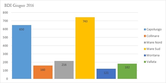
Figura SEQ Figura \* ARABIC 4: Distribuzione BDI per Macroarea
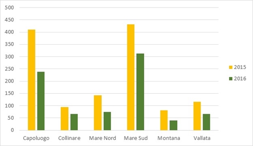
Figura SEQ Figura \* ARABIC 5 Andamento temporale dei BDI registrati
per Macroarea
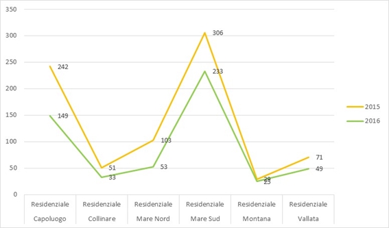
Figura SEQ Figura \* ARABIC 6 Dati BDI riferiti alla categoria
“Residenziale”
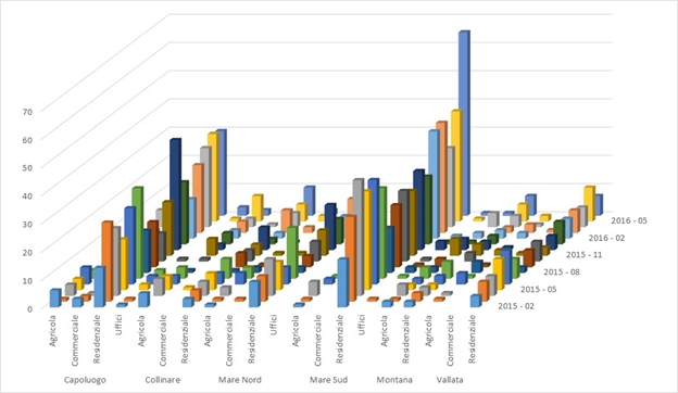
Figura SEQ Figura \* ARABIC 7 Tabella riepilogativa-comparativa dei
trend fra le Macroaree riferite agli immobili di destinazione Agricola,
Commerciale, Residenziale e Uffici

Figura SEQ Figura \* ARABIC 8 Grafico riepilogativo del Volume di
Compravendita distinto per anno
In figure 8, it is interesting to see that the total volume of title
transfers, in terms of price registered, for the first six months of
2016 have already surpassed the total volume per month of the previous
year. Despite having a negative market caused by the recent recession of
the last decade. It could be easily assumed that a sudden decrease in
the numbers of titles transferred will also happen in august 2016 when
most offices would be closed for the summer holidays.
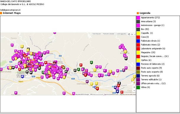
Figura SEQ Figura \* ARABIC 9 Estratto di mappa con collocazione
immobili inseriti
Interestingly, Ascoli Piceno's historic city center and the nearest
neighborhood of Porta Maggiore (figure 9) seem to be the preferred
location of most residential transactions despite having some
socio-political issues (i.e. lack of adequate car parking space,
elevated amount of carpark subscription, limited access to public and
private transportation, limited construction interventions, strict
compliance of cultural and historic construction preservation, higher
property tax quotient), in relation to newer neighborhoods and
residential expansions (Monticelli, Maltignano, Folignano).
One further improvement that the BDI project could have is to include
more detailed technical characteristics of the real estate, or some data
that could help identify the parties involved in the land transfer (age
group, previous residence area, private or company, etc). This kind of
demographic data could give a better understanding on different
urbanization phenomena and could easily help further research on urban
development of a certain market sector.
ACKNOWLEDGMENTS
A sincere thank you goes to the Provincial College of Surveyors of
Ascoli Piceno, in the person of Geom. Leo Crocetti, the College
President, and Geom. Angelo Crescenzi who spearheaded the BDI project,
both of which have been very helpful despite the setbacks and sacrifices
to be able to materialize an idea into a working and evolving project.
CONTACTS
Cromwell Manaloto
63079 Colli del Tronto (AP)
Via G. D’Annunzio 7
ITALY
Phone: 0039 349 1610645
e-mail: cromwell.manaloto@libero.it
Angelo Cresecenzi
63100 Ascoli Piceno
Via della Repubblica 45
ITALY
Phone: 0039 0736 44589
e-mail: geometracrescenzi@gmail.com
Daniele Brancato
Via Augusto Murri 12
97100 Ragusa (RG)
ITALY
Phone: 0039 329 0805477
e-mail:
danielebrancato@gmail.com
Web Site:
www.danielebrancato.it
Alessandro Dalmasso
10060 Perrero (TO)
Via Monte Nero, 6
ITALY
Phone: 0039 0121 801801
fax: 0039 0121 801801
e-mail: alessandro.dalmasso@gmail.com
Web site: www.dalmale.it
Luca Dal Buono
Via Sandri 3
40033 Casalecchio di Reno (BO)
ITALY
Phone: 0039 051 6218775 –
Fax 0039 051 6218776
Mobile 0039 347 8688458
e-mail:luca.dalbuono@collegiogeometri.bo.it
|


