Article of the Month - September 2025
|
Climate Responsive Land Governance and Disaster
Resilience: Safeguarding Land Rights in Asia
R.D. Shah and Bihar Wing Patna , India
This article in .pdf-format
(28 pages)
ABSTRACT
Climate change and disaster risks pose an increasing threat to the
livelihoods and land rights of vulnerable communities across Asia.
Effective land governance systems that are responsive to climate
challenges are critical for safeguarding land rights, building
resilience, and fostering sustainable development. This paper explores
the intersection of climate-responsive land governance, disaster
resilience, and land rights in Asia. It provides insights into regional
challenges and highlights the importance of inclusive, adaptive
governance mechanisms that integrate climate change mitigation, disaster
risk reduction, and land tenure security. Furthermore, the paper
emphasizes the need for multi-stakeholder collaboration,
capacity-building, and knowledge-sharing to address these challenges.
This study outlines the importance of effective land governance in
mitigating climate change and disaster risks for sustainable
development. Advanced technologies like LiDAR enable precise inundation
mapping, which supports accurate flood risk assessments, strategic
land-use planning, and the protection of vulnerable communities. Hazard
mapping, which covers both natural and man-made risks, is vital for
disaster management and depends on reliable data collection, risk
assessment, and GIS-based visualization.
Modernizing land records through CORS, drones, and GIS improves
transparency in land ownership, reduces disputes, and enhances
governance. Developing frameworks that are responsive to climate change
and disaster resilience is crucial for safeguarding at-risk communities.
Utilizing geospatial technologies further bolsters land-use planning and
disaster risk management.
Beside of above the paper also emphasizes the need for establishing
local land use monitoring groups is key for implementing
climate-adaptive practices on the ground. Collaboration among multiple
stakeholders promotes knowledge sharing, capacity-building, and
technology transfer, ensuring long-term resilience and sustainability in
land governance.
INTRODUCTION
Climate change is one of the most significant global challenges, with
disproportionate impacts on vulnerable regions, particularly in Asia,
where rapid urbanization, population growth, and environmental
degradation exacerbate the effects of climate-related disasters. The
region faces a variety of climate risks, including floods, cyclones,
droughts, and sea-level rise, all of which threaten land security,
especially for marginalized and low-income communities. Safeguarding
land rights and promoting disaster resilience through climate-responsive
land governance are essential to ensuring sustainable development,
disaster risk reduction, and the well-being of affected populations.
This paper focuses on:
- The impact of climate change on land rights in Asia.
- The role of land governance in building climate and disaster
resilience.
- Policy frameworks and best practices for inclusive and adaptive
land governance.
- The importance of multi-stakeholder collaboration for capacity
building and knowledge-sharing.
A. Climate Change and Land Rights in Asia
Asia is one of the most disaster-prone regions globally, with natural
disasters such as floods, landslides, and typhoons occurring frequently.
Climate change is intensifying these disasters, leading to displacement,
loss of livelihoods, and increased competition for land. Coastal regions
are particularly vulnerable, as rising sea levels and coastal erosion
threaten the land and homes of millions.
Impact on Vulnerable Communities and Land Rights at Risk
The most affected populations are often those with insecure land
tenure, including smallholder farmers, indigenous communities, and
informal settlers. Inadequate land governance systems leave these
communities without the protection needed to withstand climate shocks.
As land becomes increasingly scarce, disputes and conflicts over
ownership and usage rights are likely to increase.
| 1 |
Land Loss Due to
Environmental Degradation |
Rising Sea
Levels: |
Coastal communities face the loss of
land as sea levels rise, leading to coastal erosion, saltwater
intrusion, and the displacement of people from their homes and
farmlands. Small island nations and low-lying coastal areas are
particularly vulnerable. The gradual loss of land due to
submergence undermines land tenure security for these
communities |
|
Desertification |
In arid and semi-arid regions, climate
change exacerbates desertification, leading to the degradation
of productive agricultural land. As land becomes barren and
unproductive, farmers lose their rights to fertile land and may
be forced to migrate in search of better opportunities. |
|
Deforestation |
Forest-dependent communities, such as
indigenous groups, face loss of access to forests due to
climate-induced deforestation, including wildfires and shifts in
forest ecosystems. Their traditional rights to use and manage
forest resources are compromised when forests deteriorate or are
converted to other uses. |
| 2 |
Increased Land
Conflicts |
Competition for Resources |
As climate change reduces the
availability of arable land, water, and grazing areas,
competition for remaining resources intensifies. This leads to
land conflicts between different communities, such as
pastoralists and farmers, or between local populations Impact on
Vulnerable Communities and Land Rights at Risk and government
authorities seeking to use land for development projects or
conservation. |
| Forced
Displacement and Migration |
Climate-related disasters like floods,
droughts, and storms can force people to leave their land,
leading to displacement and migration. When communities are
displaced, they may lose their land rights or face challenges in
securing new land in their destination areas. This often creates
conflicts over land ownership in places where migrants settle.
|
| Land Grabs
and Exploitation |
Vulnerable communities are often at
risk of **land grabbing by powerful actors, including
corporations or government entities, especially when
environmental degradation reduces the value of their land. Weak
land tenure systems, coupled with the increasing value of land
for agricultural or industrial purposes, make vulnerable
communities more susceptible to exploitation and displacement.
|
| 3 |
Disruption of
Traditional Land Use and Tenure Systems |
Indigenous
Land Rights |
Indigenous peoples often have
traditional land tenure systems based on communal ownership and
sustainable land use practices. Climate change, through extreme
weather patterns and shifts in ecosystems, disrupts these
practices. For instance, changing rainfall patterns or
temperature shifts affect their ability to manage forests,
practice shifting cultivation, or rely on wildlife. This
undermines their cultural connection to the land and the
recognition of their land rights. |
|
Pastoralist Communities |
Pastoralists rely
on seasonal migration to graze livestock. Climate change
disrupts grazing patterns and water availability, forcing
pastoralists to encroach on lands traditionally used by other
communities, leading to conflict. Government policies may
restrict their mobility or fail to protect their traditional
rights to land and resources |
| 4 |
Insecure Land
Tenure |
Lack of
Legal Recognition |
Many vulnerable communities, such as
indigenous peoples or informal settlers, do not have formal
legal recognition of their land rights. Climate change can
exacerbate this vulnerability as governments and private actors
seek to acquire land for climate adaptation or mitigation
projects, such as forest conservation, renewable energy
installations, or infrastructure projects. Without secure
tenure, these communities can be displaced or denied access to
their ancestral lands. |
| Erosion of
Customary Land Rights |
Customary land rights, particularly in
rural areas, are often based on unwritten traditions and
communal ownership. Climate change-related pressures, such as
land degradation and migration, strain these systems. In the
absence of legal documentation, community members may face
challenges in defending their land from external claims or
government appropriation. |
| 5 |
Impact on
Livelihoods |
Agricultural Productivity |
Small-scale farmers and agricultural
communities are among the most vulnerable to climate change
impacts, such as changing precipitation patterns, prolonged
droughts, and heatwaves. Reduced agricultural productivity
diminishes their ability to maintain their land, often leading
to loss of land through debt or forced migration. This loss of
productive land can undermine their rights to access and use
land for agricultural purposes. |
| Livelihood
Shifts |
As traditional livelihoods become less
viable due to climate impacts, vulnerable communities may need
to shift to alternative livelihoods. However, access to land for
new forms of income, such as tourism, aquaculture, or renewable
energy, may be restricted. This can further marginalize
vulnerable groups and limit their ability to adapt to changing
environmental conditions |
| 6 |
Displacement and
Resettlement |
Climate-Induced Displacement |
Natural disasters such as floods,
storms, and landslides can displace entire communities.
Displacement often results in the permanent loss of land, as
returning to homes or farms may be impossible due to
environmental degradation or new land use policies. Displaced
individuals may have no legal claims to new land or find
themselves in precarious informal settlements with limited
rights. |
| Inadequate
Resettlement Programs |
When governments implement resettlement
programs for communities displaced by climate change or
development projects, these programs often fail to provide
secure tenure in new locations. Communities may be resettled in
areas with poor infrastructure, inadequate land for farming, or
without legal titles to the land, leading to long-term
insecurity. |
| 7 |
Government Policies
and Adaptation Projects |
Climate
Mitigation and Adaptation Projects |
Government policies aimed at mitigating
climate change, such as forest conservation, reforestation, or
the creation of protected areas, can undermine the land rights
of vulnerable communities. For example, communities living in
forested areas may lose access to forest land when it is
designated for carbon sequestration or conservation projects.
Similarly, large-scale infrastructure projects related to
climate adaptation, such as dams or flood barriers, may displace
communities without adequate compensation or relocation plans. |
| Land Use
Changes |
Governments may prioritize land use
changes for climate adaptation (e.g., creating buffer zones
along coasts or floodplains) that restrict access to land
traditionally used by vulnerable communities. Without proper
consultation and compensation, these communities may lose their
land rights in the name of climate action. |
| 8 |
Gender-Specific Impacts |
Women’s
Land Rights |
|
| 9 |
Legal and Policy Gaps |
|
Lack of Climate-Responsive Land Laws:
Many countries lack land laws that account for the impacts of
climate change on vulnerable communities. Governments may
prioritize economic growth over social equity, resulting in
policies that favor land acquisition for development or
conservation at the expense of vulnerable groups. Legal
frameworks may not recognize or protect the land rights of
informal settlers, indigenous peoples, or other marginalized
groups affected by climate change. |
B. Climate-Responsive Land Governance
Climate-responsive land governance is essential for reducing
vulnerability to climate-related risks and ensuring that land rights are
preserved even in the face of disasters. A proactive approach to land
governance integrates climate change adaptation strategies and disaster
risk management into land-use planning, tenure security, and policy
development.
Key Principles
Adaptability
Land governance systems must be flexible enough to adapt to changing
environmental conditions and disaster risks. This requires updating land
policies, zoning regulations, and land-use plans to incorporate climate
projections and disaster risk assessments.
Inclusiveness
Effective land governance must be inclusive, ensuring the
participation of all stakeholders, especially marginalized groups, in
decision-making processes. Women's land rights and the land tenure of
indigenous and local communities are particularly important.
Equity
Equitable access to land and resources is vital in times of climate
stress.
Land governance should prioritize the protection of vulnerable
communities, ensuring that their land rights are recognized and secured.
Transparent
Transparency and Accountability
Transparent land administration systems are crucial for reducing
corruption and ensuring fair distribution of land resources in the
aftermath of disasters.
C. Disaster Resilience and Land Governance
Building disaster resilience requires integrating land governance
with broader disaster risk reduction strategies. Strengthening land
tenure systems and improving land use planning are central to reducing
vulnerabilities and enhancing recovery efforts.
Role of Land Governance in Disaster Resilience:
- Prevention :- Implementing land-use policies that restrict
development in high-risk areas, such as floodplains or coastal
zones, can prevent loss of life and property.
- Response :- After a disaster, secure land rights are critical
for effective recovery and reconstruction. Establishing clear
procedures for land restitution or compensation is essential to
avoiding land disputes.
- Recovery :- Post-disaster recovery programs must include land
tenure security as a core component, ensuring that displaced
communities can return to their land or receive equitable
compensation.
Land governance plays a crucial role in disaster management by
ensuring that land is used, planned, and managed in ways that reduce
vulnerability to natural disasters. Here’s a brief list of its key
roles: Equity Transparency and Accountability
- Risk Assessment and Zoning: Land governance involves creating
hazard maps and zoning regulations to identify high-risk areas prone
to disasters like floods, landslides, or earthquakes, and
restricting development in these zones.
- Land Use Planning: It ensures that land use planning integrates
disaster risk reduction strategies, guiding the location of
settlements, infrastructure, and economic activities to safer areas.
- Secure Land Tenure: Strengthening land tenure security ensures
that vulnerable communities can rebuild after disasters, reducing
conflicts and displacement risks.
- Resilient Infrastructure: Land governance promotes the
construction of disaster-resilient infrastructure, such as flood
barriers and earthquake-resistant buildings, especially in high-risk
areas.
- Post-Disaster Recovery: Effective land governance facilitates
the fair and timely distribution of land for rebuilding and
relocation after disasters, ensuring equitable access to resources
for affected populations
- Community Involvement: Involving local communities in land
management ensures that disaster risk reduction measures are
culturally appropriate and sustainable.
- Environmental Protection: It promotes sustainable land use
practices that protect natural ecosystems, such as wetlands and
forests, which act as natural buffers against disasters.
Best Practices for Land Governance in Disaster Contexts:
Best Practices for Land Governance in Disaster Contexts focus on
creating resilient, inclusive, and adaptive land use policies that
reduce disaster risk, enhance recovery, and safeguard the land rights of
vulnerable populations. Here are some key best practices:
1. Integrated Risk Assessments
- Conduct Hazard Mapping: Identify areas prone to natural hazards
such as floods, landslides, earthquakes, or droughts using
comprehensive hazard maps. Incorporate these into land-use planning
and zoning regulations.
- Assess Vulnerability: Assess the vulnerability of different
populations and sectors to disasters, factoring in socio-economic,
environmental, and cultural considerations.
2. Risk-Informed Land Use Planning
- Disaster-Resilient Zoning: Implement zoning regulations that
restrict development in high-risk areas, like floodplains, coastal
zones, or landslide-prone regions, while promoting safer zones for
settlements and infrastructure.
- Climate Adaptation: Integrate climate adaptation strategies into
land use planning to ensure long-term sustainability, including
preserving natural buffers like wetlands and forests that reduce
disaster impacts.
3. Strengthening Land Tenure and Rights
- Secure Tenure for Vulnerable Communities: Ensure that vulnerable
groups, including women, indigenous peoples, and informal settlers,
have secure land rights. This facilitates rebuilding efforts
post-disaster and reduces the risk of land grabs or forced
displacement.
- Legal Frameworks: Strengthen land tenure systems by updating
legal frameworks to recognize customary and informal land rights,
especially in post-disaster recovery.
4. Inclusive and Participatory Governance
- Community Involvement: Engage local communities, especially
marginalized groups, in land governance processes. Their input
ensures that disaster risk reduction measures are contextually
appropriate and sustainable.
- Multistakeholder Coordination: Foster collaboration between
government agencies, local authorities, civil society, and the
private sector to coordinate land use decisions and disaster risk
reduction strategies.
5. Sustainable Land Management
- Protect Ecosystems: Promote land management practices that
conserve natural ecosystems, such as forests, wetlands, and
mangroves, which act as natural defenses against disasters like
floods and storms.
- Sustainable Agriculture: Encourage sustainable farming practices
that reduce land degradation, enhance soil fertility, and minimize
the impacts of droughts or floods.
6. Building Resilient Infrastructure
- Disaster-Resistant Construction: Enforce building codes that
ensure infrastructure is resilient to hazards such as earthquakes,
floods, and storms, particularly in high-risk areas.
- Relocation Strategies: Develop relocation plans for communities
in extremely high-risk areas, ensuring fair and transparent
processes that respect land rights and provide adequate
compensation.
7. Post-Disaster Land Recovery
- Clear Land Rights in Recovery: After disasters, ensure swift and
clear identification of land ownership to facilitate reconstruction.
This minimizes land disputes and allows faster rebuilding.
- Fair Compensation and Resettlement: Ensure that land-based
compensation and resettlement programs are equitable, transparent,
and provide secure tenure to displaced communities.
8. Data Collection and Technology Use
- GIS and Remote Sensing: Use Geographic Information Systems (GIS)
and remote sensing technologies for real-time data collection on
land use, hazards, and vulnerabilities. These tools help in planning
and disaster management.
- Digital Land Registries: Develop and maintain digital land
registries to keep track of land ownership and use. This helps with
efficient disaster recovery and reduces corruption or disputes.
9. Legal and Policy Reforms
- Land Policy Harmonization: Ensure that disaster risk reduction
policies are aligned with broader land policies, climate change
adaptation, and sustainable development goals (SDGs).
- Regular Updates to Land Laws: Continuously update land
governance laws and policies to address emerging risks from climate
change and other environmental threats.
10. Monitoring and Enforcement
- Regular Inspections: Conduct regular inspections of high-risk
areas to ensure compliance with zoning laws, building codes, and
disaster-preparedness measures.
- Early Warning Systems: Establish early warning systems that
provide communities with real-time information about impending
natural hazards, allowing for evacuation and other preventive
measures.
5. Case Studies from Asia
Several countries in Asia have made progress in integrating climate
resilience into land governance systems. This section presents brief
case studies that highlight the success and challenges of such efforts.
A. Bangladesh
Background:
Bangladesh is one of the world’s most vulnerable countries to climate
change due to its low-lying geography, population density, and reliance
on agriculture. It faces increasing risks from floods, cyclones, and
rising sea levels, which have prompted the government to integrate
climate resilience into its land use and governance systems.
Key Initiatives:
- Coastal Zone Management: The Bangladesh Coastal
Zone Policy (2005) focuses on reducing the vulnerability of coastal
communities by promoting sustainable land use, protecting mangroves,
and restricting development in high-risk areas. This policy
integrates climate resilience by managing land in a way that reduces
the impact of cyclones and storm surges.
- Land Use Planning Act (2010): This act outlines
disaster-sensitive land use planning, promoting the development of
infrastructure in safer areas. It supports zoning regulations that
restrict settlements in flood-prone areas while improving drainage
and flood protection measures.
- National Adaptation Plan of Action (NAPA):
Bangladesh’s NAPA promotes community-based adaptation strategies,
including flood-resistant housing, saline-tolerant crops, and the
restoration of natural floodplains. This plan integrates climate
resilience into agriculture and land management to mitigate the
impact of floods and cyclones.
Outcomes:
- Resilient Housing: The construction of flood-
and cyclone-resistant houses has helped protect vulnerable
communities from frequent disasters.
- Mangrove Reforestation: Bangladesh’s successful
reforestation of mangrove forests, such as in the Sundarbans, has
provided natural protection against cyclones, protecting both people
and land.
- Community-Based Adaptation: Local communities
are directly involved in disaster planning and land management,
making them more resilient to climate-induced changes.
B. NEPAL
1. National Land Use Policy (2015)
Nepal’s National Land Use Policy (2015) is a critical framework for
integrating climate resilience into land governance. The policy aims to
regulate land use based on its capability, risk levels, and the need to
protect vulnerable areas. It emphasizes the importance of
climate-adaptive land use practices, risk-informed zoning, and
sustainable natural resource management.
- Land Zoning and Hazard Mapping: The government
has categorized land into different zones (agricultural, forest,
urban, and industrial), with specific restrictions on land use based
on climate and disaster risks. High-risk areas, such as floodplains
and landslide-prone zones, are designated for conservation or
restricted development.
- Community-Based Forest Management: Forest land,
particularly in hilly regions, is managed through community-based
systems. These systems focus on sustainable forest management,
erosion control, and promoting ecosystem resilience, which helps
protect vulnerable communities from climate-induced disasters.
2. Disaster Risk Reduction (DRR) and Climate Change Adaptation (CCA)
Nepal has made efforts to mainstream disaster risk reduction and
climate change adaptation into land governance policies.
- Local Adaptation Plans of
Action (LAPAs): The LAPA framework ensures that
local governments integrate climate resilience into land-use
decisions. Communities participate in identifying climate risks and
implementing adaptation measures such as water management systems,
slope stabilization projects, and reforestation to prevent
landslides.
- Building Codes and
Disaster-Resilient Infrastructure: Nepal has adopted
building codes to ensure that infrastructure development, especially
in urban areas, considers seismic and climate risks. The focus on
climate-resilient construction helps reduce vulnerability to
earthquakes, floods, and landslides.
3. Glacial Lake Outburst Flood (GLOF) Risk Reduction
With the growing threat of GLOFs due to climate change, Nepal has
implemented targeted measures to reduce risks from glacial lakes.
- Early Warning Systems: Nepal has installed
early warning systems in areas at risk of GLOFs, particularly around
large glacial lakes. These systems help protect communities
downstream by providing real-time information on potential floods.
- Monitoring and Drainage of Glacial Lakes: The
government, with support from international agencies, monitors and
manages glacial lakes, reducing water levels through controlled
drainage systems to minimize the risk of sudden outbursts.
4. Land Tenure and Vulnerable Communities
Nepal’s climate resilience efforts also focus on ensuring land tenure
security, particularly for vulnerable groups like indigenous
communities, women, and smallholder farmers. Secure land tenure is
essential for climate adaptation, as it empowers communities to invest
in long-term land management practices.
Legal Recognition of Customary Land Rights: Nepal’s land governance
framework acknowledges customary land rights, particularly for
indigenous communities living in forests and high-risk areas. This
recognition allows these communities to engage in sustainable resource
management practices that enhance climate resilience.
- Gender-Inclusive Land Governance: Land governance reforms in Nepal aim
to improve land rights for women, who are often disproportionately
affected by climate change. Providing women with secure land tenure
enables them to implement climate-resilient agricultural practices and
strengthens community resilience.
5. Sustainable Agriculture and Climate-Resilient Practices
Agriculture is a major source of livelihood in Nepal, and integrating
climate resilience into farming practices is critical to protecting food
security and rural livelihoods.
- Climate-Smart Agriculture: Nepal promotes
climate-smart agriculture through soil conservation,
drought-resistant crops, and improved irrigation techniques. Terrace
farming, a traditional method in the hilly regions, has been
revitalized to prevent soil erosion and manage water resources more
effectively.
- Agroforestry: Agroforestry systems, which
combine trees and crops, are being promoted to enhance soil
fertility, reduce erosion, and provide a buffer against climate
impacts.
6. Institutional Strengthening and Capacity Building
Effective land governance requires strong institutions and local
capacity. Nepal has invested in strengthening institutions to implement
climate-resilient land governance.
- Training and Capacity Building: Local
governments and communities are trained in climate-resilient land
use practices, hazard mapping, and disaster preparedness. This
ensures that land governance at the local level is equipped to
handle climate challenges.
- Cross-Sectoral Collaboration: The integration
of climate resilience into land governance involves collaboration
between various sectors, including agriculture, forestry, urban
planning, and disaster management. This holistic approach helps
ensure that land use decisions are informed by climate risks.
C India
Integrating Climate Resilience into Land Governance Systems
Background
India faces growing climate risks due to rising temperatures, erratic
monsoons, and increased intensity of extreme weather events. Vulnerable
regions like coastal areas, river basins, and semi-arid lands are
home to millions of people who depend heavily on agriculture, fisheries,
and natural resources for their livelihoods.
Key challenges include:
- Increased Frequency of Disasters : India experiences regular
natural disasters, including floods, cyclones, and droughts,
exacerbated by climate change.
- Vulnerable Communities: Many marginalized communities, including
small-scale farmers, fishers, and coastal populations, are highly
vulnerable due to their reliance on climate-sensitive livelihoods.
- Pressure on Land Resources: Rapid urbanization and population
growth exert pressure on land, leading to unsustainable land use
practices that increase vulnerability to disasters.
Policy Frameworks for Climate Resilient Land Governance
1. National Action Plan on Climate Change (NAPCC):
India’s NAPCC, launched in 2008, is the cornerstone of its climate
policy. It comprises eight national missions, several of which focus on
integrating climate resilience into land governance:
- National Mission for a Green India (GIM):
Focuses on reforestation and ecosystem restoration, emphasizing land
management practices that protect vulnerable areas and communities
from the impacts of climate change.
- National Mission for Sustainable Agriculture (NMSA):
Aims to promote climate-resilient agriculture through sustainable
land management techniques, including crop diversification, water
conservation, and soil management to reduce vulnerability to
droughts and floods.
2. Disaster Management Act, 2005:
This act institutionalizes disaster risk reduction (DRR) as part of
land governance in India. It mandates disaster risk assessments and
hazard mapping, ensuring that land use planning considers disaster
risks. For example, regions prone to floods or landslides have special
zoning regulations to restrict development in high-risk areas.
3. National Policy on Resettlement and Rehabilitation (2007):
This policy addresses the resettlement of communities displaced by
natural disasters or climate change impacts, ensuring that their land
rights and livelihoods are protected during relocation.
4. SOCIETY OF INTEGRATED COASTAL MANAGEMENT (SICOM) MINISTRY OF
ENVIRONMENT & FORESTS
conducted ICZM project for Provision of Ground Controls and
Digital Photogrammetric Work of approximately 7 km. wide coastal belt of
Indian mainland including major deltaic areas and back waters, for
delineation of hazard line.
Since India has about 7500 Km coastal line (5400Km on mainland) and
250 million people are living with in 50 Km distance from Sea shore.The
coastal area of India accommodates 130 cities and large number of
villages.
In view of above. Swami Nathan committee recommended to number of
reforms to facilitate conservation of eco system in coastal zone to
promote economic development and poverty reduction in the costal areas.
The MINISTRY OF ENVIRONMENT & FORESTS had take up this work with
collaboration with Survey of India ,Ministry of Science & Technology
Main technical factor for hazard lime mapping under ICZM was
as under:
- 05 metre elevation contour map on 1:10000 scale upto 7 Km from
sea shore
- Digital elevation Model DEM
- used digital stereo aerial photographs of 9 cm GSD for
delineation of hazard line
- Planning and Provision of Planimetric ground control points by
dual frequency GNSS/GPS receivers in relative static positioning
mode and heights by differential Spirit Levelling (Total Station /
GPS Levellling in Hilly/difficult areas ) required for
Photogrammetric Block control.
- Inundation Modelling and digitization of Flood line and
determining areas of inundation by the estimated flood of 100 years
return period
- Digital shoreline Analysis of time series coastline data (3
nos.) to study the trends of shore-line change and arithmetically
project the shoreline for next 100 years.
- Prepared of digital maps on the base of ortho-imagery and
depicting contours at 0.5m (2.5m for hills).
Key Initiatives Integrating Climate Resilience and Land Governance
1. Climate-Resilient Agriculture in Maharashtra:
Maharashtra, a state prone to severe droughts, has implemented
climate-resilient agricultural practices through the Maharashtra Climate
Resilient Agriculture Project (MCRAP). The initiative integrates land
governance with climate adaptation strategies by:
- Land Management for Water Conservation: Techniques like contour
bunding, watershed management, and rainwater harvesting help
mitigate the impacts of drought.
- Sustainable Land Use: The project encourages farmers to adopt
sustainable cropping patterns and climate-resilient crops, reducing
the dependence on water-intensive crops.
2. Odisha’s Cyclone Resilient Land Use Planning:
In India, Odisha is widely acknowledged as a leading state in
implementing disaster resilience, particularly in terms of preparedness
and response to coastal disasters like cyclones, using maps developed
under the Integrated Coastal Zone Management (ICZM) project. Odisha's
approach to building disaster resilience is often regarded as a model
for other states and countries, especially in the context of cyclone
management. Through ICZM projects, the following types of maps were
prepared to support disaster resilience efforts.
| Name of
Map |
Purpose
|
Uses
|
Example
|
Remarks
|
| Hazard Mapping |
To identify areas at risk
from natural hazards like cyclones, tsunamis, coastal flooding,
and erosion. |
Hazard maps show which
parts of the coastal zone are most vulnerable to natural
disasters, allowing authorities to prioritize risk reduction
|
In Odisha, hazard maps are used to
highlight cyclone-prone zones and areas at risk of flooding from
storm surges. This helps in planning evacuation routes and
determining where to |
|
| Vulnerability Mapping
|
To assess the
vulnerability of coastal communities, infrastructure, and
ecosystems. |
Vulnerability maps combine
information on social, economic, and physical vulnerabilities,
such as population density, poverty levels, and weak
infrastructure. |
Vulnerability maps of coastal regions
in West Bengal help determine which areas need more robust
evacuation plans and where infrastructure needs to be fortified
to withstand storms. |
|
| Risk Mapping |
To integrate hazard and
vulnerability data to create risk maps. |
These maps help planners
assess the overall risk in a coastal area by factoring in both
the likelihood of hazards and the community's capacity to cope
with them. |
Risk maps are used in Gujarat to
prioritize investments in protective infrastructure like
seawalls and mangrove restoration, aimed at reducing the overall
risk of coastal erosion and flooding. |
|
| Ecosystem and Land Use Mapping
|
To track changes in
coastal ecosystems and land use, helping in ecosystem-based
disaster risk reduction. |
Land use maps show areas
where human activities, such as construction or agriculture, are
impacting coastal ecosystems. This helps in planning
interventions like mangrove reforestation to enhance natural
barriers. |
In Odisha, mangrove mapping is used to
identify areas where mangroves have degraded and need
restoration. Mangroves act as natural buffers against storm
surges, reducing the impact of cyclones. |
|
| Real-Time Mapping and Early
Warning Systems |
To provide real-time data
on approaching hazards, allowing for timely evacuations and
disaster response. |
Satellite-based maps,
along with Geographic Information System (GIS) technology, can
provide real-time updates on weather patterns, water levels, and
storm surges. |
Real-time flood maps are used in Tamil
Nadu to track rising water levels during monsoons and cyclones,
helping authorities coordinate evacuations in low-lying areas.
|
|
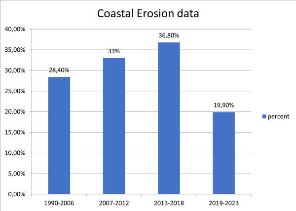
| Shoreline Change Mapping:
|
To monitor coastal erosion
and accretion (land buildup), which is vital for planning
long-term coastal resilience. |
Shoreline change maps show
how the coastline is shifting due to natural processes and human
activities. These maps help in planning protective measures like
beach nourishment or constructing embankments. |
In Gujarat, shoreline
change mapping is used to predict areas at risk of erosion and
determine where to build coastal protection structures. |
|
| Infrastructure Mapping
|
To map critical
infrastructure (e.g., roads, hospitals, schools, and shelters)
that needs to be protected or upgraded to withstand disaster
|
Odisha, frequently hit by
cyclones, has developed a comprehensive land use planning
strategy to protect coastal communities: |
|
|
| Coastal Zone Management Plans
|
Odisha’s Integrated
Coastal Zone Management (ICZM) project focuses on sustainable
land use practices, including mangrove restoration, which acts
as a natural buffer against storm surges. |
|
|
|
| Resilient Housing and
Infrastructure |
In cyclone-prone regions,
land governance policies require the construction of
cyclone-resistant housing and infrastructure, reducing
vulnerability during extreme weather events |
|
|
|
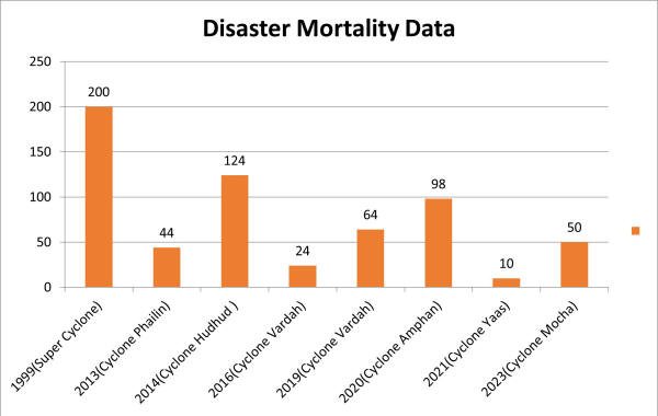
Based on the above maps, the state of Odisha implemented measures and
developed infrastructure accordingly. The results of these efforts have
been observed in a decreasing trend, as outlined below.
3. Rajasthan’s Drought Mitigation Efforts:
Rajasthan, one of the driest states in India, has integrated climate
resilience into its land governance system to address recurring
droughts:
- Watershed Management and Land Conservation: The state’s programs
focus on improving land use in drought-prone areas through water
harvesting, soil conservation, and reforestation projects.
- Desert Development Program: This program integrates land use
planning with climate adaptation to combat desertification and
improve the livelihoods of rural communities dependent on
agriculture.
D. The Philippines:
Land Use Planning and Hazard Mapping for Climate Resilience
Background:
The Philippines is frequently affected by typhoons, floods, and
landslides. As a response, the government has adopted a multi-faceted
approach to integrate climate resilience into its land governance system
through legislation, land use planning, and hazard mapping.
Key Initiatives:
- Philippine Disaster Risk Reduction and Management Act
(2010): This law mandates the integration of disaster risk
reduction into national and local land use planning, ensuring that
development activities are designed to minimize exposure to natural
hazards.
- Hazard Mapping and Land Use Plans: The
Philippines has developed “nationwide hazard maps” that show areas
vulnerable to floods, landslides, and storm surges. These maps
inform local governments on zoning restrictions and land use
policies. They also help identify safer areas for housing and
infrastructure development.
- Enhanced Local Climate Change Action Plans (LCCAPs):”
The Climate Change Act (2009)” requires local governments to develop
LCCAPs, integrating climate adaptation strategies into their land
use policies. These plans are informed by hazard maps and include
restrictions on building in high-risk areas.
Outcomes:
- Resilient Infrastructure: Local governments
have developed disaster-resilient infrastructure, such as flood
control systems, and have relocated vulnerable communities to safer
zones.
- Improved Zoning Laws: Hazard maps have
strengthened zoning regulations that prevent construction in
landslide-prone and flood-prone areas, thus reducing the exposure of
communities to natural disasters.
- Public Awareness: Through public education
campaigns, citizens are more aware of climate risks, contributing to
more informed land use decisions.
E. Vietnam :
Integrating Climate Adaptation into Land Management
Background:
Vietnam is one of the most climate-vulnerable countries due to its
long coastline and dependence on agriculture. Rising sea levels,
increasing temperatures, and extreme weather events, such as typhoons
and floods, threaten its coastal and delta regions.
Key Initiatives:
- National Strategy for Natural Disaster Prevention,
Response, and Mitigation (2007-2020): This strategy
integrates disaster risk reduction and climate adaptation into land
use planning, particularly in
the highly vulnerable Mekong Delta region. It emphasizes zoning
regulations that restrict settlements in flood-prone areas and
encourages the construction of flood-proof houses.
- Mekong Delta Plan: The government has adopted
an integrated approach for the Mekong Delta region, focusing on land
use changes, water management, and climate adaptation. The plan
promotes shifting agricultural practices to saline-tolerant crops
and encouraging farmers to relocate from high-risk areas to safer
locations.
- Law on Land (2013): Vietnam’s land law
integrates climate resilience by ensuring that land allocation and
zoning decisions take climate risks into account. This is
particularly relevant in areas prone to coastal erosion and
saltwater intrusion.
Outcomes:
- Adaptive Agriculture: Farmers in the Mekong
Delta have adopted climate-resilient agricultural practices,
including switching to saline-tolerant rice varieties, which have
reduced the impact of sea level rise on livelihoods.
- Relocation of Vulnerable Communities: Vietnam
has relocated thousands of people from areas at risk of flooding and
coastal erosion to safer, inland areas. The government provides land
titles in these new areas to ensure security of tenure.
- Ecosystem-Based Adaptation: The country has
undertaken efforts to restore mangroves and wetlands to act as
natural buffers against storms and floods, protecting both land and
communities.
6. Building Capacity and Fostering Collaboration
Addressing the complex challenges of climate-responsive land
governance and disaster resilience requires collaboration between
governments, civil society, the private sector, and international
organizations. This paper calls for a multi-stakeholder approach that
fosters knowledge-sharing, capacity-building, and technology transfer.
Capacity Building:
Building the capacity of national and regional institutions is
crucial for implementing climate-responsive land governance policies.
This includes training policymakers, land administrators, and community
leaders in climate adaptation, disaster risk reduction, and inclusive
land governance.
Technology Transfer and Innovation:
Innovative technologies, such as GIS, drones, and remote sensing,
offer new opportunities for improving land governance and disaster
resilience. Collaborative efforts between governments and technology
providers can enhance the ability to monitor land use, assess climate
risks, and respond to disasters effectively.
7. Conclusion
Safeguarding land rights in the face of climate change and disaster
risks is a critical challenge for Asia. Climate-responsive land
governance offers a pathway to protecting vulnerable communities,
reducing disaster risks, and promoting sustainable development. The
integration of adaptive land governance policies, disaster risk
reduction, and inclusive participation can help build resilient systems
that ensure land rights for all, even in the face of climate-induced
challenges. Through capacity-building, technology transfer, and
multi-stakeholder collaboration, the region can develop solutions that
safeguard land rights and foster long-term resilience.
8. Recommendations:-
A-Conduct Inundation mapping using advance Tecchnlogy
:-Inundation maps are critical tools for flood risk assessment and
disaster management, especially in flood-prone areas along rivers. These
maps help identify areas that are likely to be flooded during heavy
rainfall or high river discharge, enabling effective land use planning
and, if necessary, the relocation of inhabitants from high-risk zones.
LiDAR (Light Detection and Ranging) technology plays a key role in
creating large-scale inundation maps with high accuracy and precision,
especially in regions with complex terrain or dense vegetation.
B-Conduct Hazard mapping :-This is an indispensable
tool for disaster management and land use planning. By identifying
high-risk areas, these maps enable governments, organizations, and
communities to mitigate risks, design resilient infrastructure, and
improve emergency preparedness. As climate change increases the
frequency and intensity of many natural hazards, the importance of
accurate, up-to-date hazard mapping continues to grow. Through ongoing
advancements in remote sensing technologies like LiDAR and GIS, hazard
maps are becoming more precise, allowing for better decision-making and
enhanced resilience to future disasters.
Types of Hazards mapping
1. Natural Hazards:
- Earthquakes: Seismic hazard maps show zones prone to earthquakes
based on fault lines, historical seismic activity, and geological
conditions.
- Landslides: Slope stability, soil types, and rainfall patterns
are used to predict landslide-prone areas.
- Cyclones: Coastal regions vulnerable to cyclones and storm
surges are mapped based on wind speed models and historical storm
patterns.
- Droughts: Hazard maps identify regions at risk of prolonged dry
spells by analyzing rainfall, soil moisture, and climate data.
- Volcanic Eruptions: Volcanic hazard maps highlight areas
vulnerable to lava flows, ashfall, and pyroclastic surges.
2. Man-made Hazards:
- Industrial Accidents: Hazard mapping identifies areas around
factories or plants where toxic releases, explosions, or fires could
occur.
- Nuclear Accidents: Maps focus on zones around nuclear power
plants that would be at risk of radiation exposure in the event of a
disaster.
- Transportation Accidents: These maps identify high-risk
transportation routes (e.g., roads, railways) where accidents
involving hazardous materials could happen.
Components of Hazard Mapping
1. Data Collection: Hazard mapping relies on collecting accurate and
extensive data from multiple sources:
- Historical Data: Information on past disasters is essential for
understanding where hazards have occurred and their impacts.
- Geospatial Data: Remote sensing technologies like LiDAR,
satellites, and aerial surveys provide valuable topographical and
environmental data.
- Hydrological and Meteorological Data: Weather patterns, river
discharge levels, and other environmental factors help in predicting
hazards like floods and droughts.
- Seismological Data: For seismic hazards, data on fault lines,
tectonic plates, and earthquake activity are crucial.
2. Risk Assessment: After data collection, risk assessments are
conducted to estimate the probability of a hazard occurring in a given
area and the potential consequences. These assessments consider factors
like:
- Population Density: More densely populated areas are at greater
risk in the event of a disaster.
- Infrastructure: Critical infrastructure such as bridges, roads,
schools, and hospitals is factored into risk assessments.
- Land Use Patterns: Urban areas, agricultural land, and natural
ecosystems are assessed for vulnerability based on their exposure to
hazards.
3. Modeling:
Mathematical models and simulations are used to forecast the
potential impact of future hazards. For example, flood models simulate
how water would flow across different terrains, while seismic models
predict the spread of earthquake waves. These models help refine hazard
maps, making them more precise and reliable.
4. Visualization: Once data is collected and analyzed, hazard maps
are generated, typically with Geographic Information Systems (GIS). The
maps are often color-coded to show different levels of risk
- Red Zones: High-risk areas where hazards are likely to occur
with severe consequences.
- Yellow Zones: Moderate-risk areas where hazards may occur less
frequently but still pose a significant threat.
- Green Zones: Low-risk areas that are less likely to experience
hazards.
1. Earthquake Hazard Maps: Earthquake hazard maps
show regions susceptible to seismic activity based on tectonic plates
and fault lines. These maps are used to guide building codes, ensuring
that structures are designed to withstand potential earthquake forces,
especially in high-risk zones.
2. Landslide Hazard Maps: Landslide hazard maps are
developed for mountainous or hilly areas where soil erosion, rainfall,
and steep slopes can lead to landslides. These maps aid in
infrastructure development and prevent construction in areas where the
risk of landslides is high.
3. Cyclone/Storm Surge Maps: These maps show coastal
areas at risk from cyclones, high winds, and storm surges. They are
crucial for early warning systems and emergency evacuation planning,
helping to protect coastal populations and infrastructure.
4. Drought Hazard Maps: Drought maps identify areas
vulnerable to prolonged water shortages, particularly in semi-arid or
arid regions. They support water resource management, agricultural
planning, and drought resilience strategies.
5. Volcanic Hazard Maps: Volcanic maps highlight
zones around active volcanoes that could be affected by lava flows,
ashfall, or pyroclastic surges. These maps help authorities issue
evacuation orders and implement hazard mitigation measures.
C- Preparation of Digital Land Records Using CORS, Drone Technology,
and GIS Platform
The preparation of digital land records using modern technologies
such as CORS (Continuously Operating Reference Stations), drone
technology, and GIS (Geographic Information System) is revolutionizing
land governance. This approach ensures accurate land ownership details,
efficient land use planning, and reduces disputes over land boundaries
by providing precise and up-to-date land records. Here’s an in-depth
look at how these technologies work together to create digital land
records.
Since Traditional land records often suffer from inaccuracies due to
outdated or poorly maintained data, leading to land disputes,
inefficiencies in land transactions, and challenges in governance.
Digital land records address these issues by providing accurate,
real-time data that is easily accessible, transparent, and reliable.
They allow governments, landowners, and other stakeholders to manage
land ownership, transactions, and disputes more effectively.
D- Develop and implement national and regional land
governance frameworks that are climate-responsive and
disaster-resilient.
E Prioritize the protection of vulnerable
communities by recognizing and formalizing land rights, especially in
disaster-prone areas.
D Leverage geospatial technologies to improve
land-use planning and disaster risk management.
E Strengthen legal frameworks to ensure
transparent, equitable, and accountable land governance.
F Establishing a Local Land Use
Monitoring Group: Planning Land Use with Advanced Recommendations
The establishment of a Land Use Monitoring Group at the local level
is essential for ensuring sustainable, equitable, and climate-responsive
land use. This group would be responsible for implementing
recommendations based on modern geospatial technologies like CORS, drone
surveys, and GIS platforms, alongside promoting sustainable practices
that address climate change, disaster resilience, and reducing land
disputes.
G Foster multi-stakeholder collaboration to
enhance knowledge-sharing, capacity-building, and technology transfer at
the regional level.
References
- UN-Habitat. (2020). Land and Climate Change: The Linkages
Between Land and Climate Change.
- FAO. (2019). Land Tenure and Climate Vulnerability:
Strengthening Resilience in Rural Communities.
- World Bank. (2021). Land Governance in Asia: Opportunities and
Challenges in the Context of Climate Change.
- UNDRR. (2020). The Role of Land Governance in Building Disaster
Resilience.