FIG PUBLICATION NO. 42
Informal Settlements:
The Road Towards More Sustainable Places
Contents
Foreword
Executive Summary
1 Introduction
2 Geography of People
3 Building Sustainable Places
Issue 1: New Approaches to Spatial Planning
Issue 2: At the Crossroads – Appropriate Building Standards
and Regulatory Codes
Issue 3: Best Vehicles – to Improve Settlements through
Upgrading Mechanisms
Issue 4: Highways – Creating routes for the Provision and
Development of Infrastructure
4 Building Partnerships
Issue 1: Driving with Traditional Leaders
along Parallel Tracks
Issue 2: Positive Passengers, a Participatory Approach
Issue 3: Steering through Knowledge and Information
Management
5 Building The Capacity
Where the strategic alliances lie
6 Conclusions
Appendices and References
Orders for printed copies
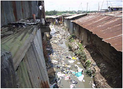
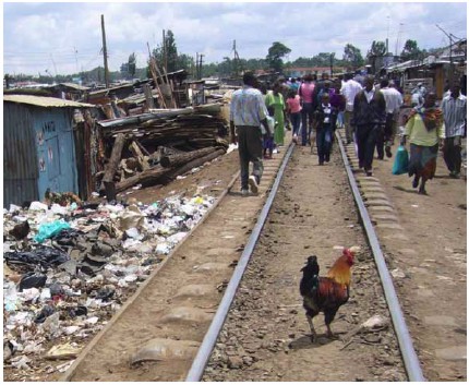
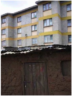
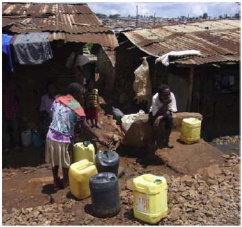
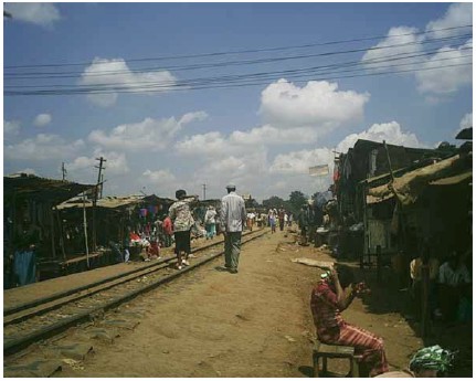
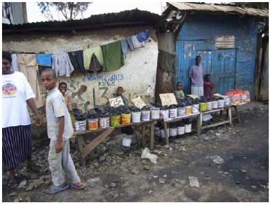
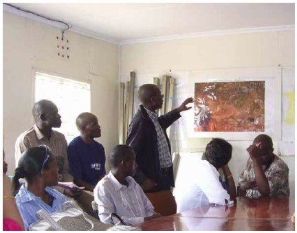
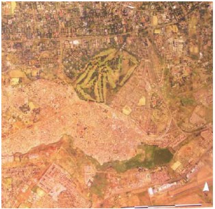
Photographs in this publication are from informal settlements
in Kibera, Nairobi, Kenya
covering 150 hectares for over one million slum dwellers. © FIG, 2007–2008.
During the term 2002–2006, FIG’s cross commission Working
Group 8.3 considered the particular issue of the urbanisation process in
relation to informal settlements, with much of the initial evidence drawn
from peri urban areas of Sub Saharan Africa. The group sought to reach a
better understanding of the important role that surveyors might play in the
provision of sustainable housing and development patterns in informal
settlements.
The aim of this publication is to explore how surveyors, in this
area of informal settlements, can be better prepared to work with international
agencies, national and local government, supported by the use of appropriate
technology and information. This publication sets out the working group’s
findings and suggestions for the road ahead.
The full report from Working Group 8.3 is available at
www.fig.net/commission8. The
working group aimed to take a pragmatic, practical approach, devised through
cooperation with UN-Habitat. The statement builds upon existing FIG
publications, including the Bathurst (#21), Marrakech (#33) and Aguascalientes
(#34) declarations, together with Land Information Management for Sustainable
Development of Cities (#31), and the Nairobi Statement on Spatial Information
for Sustainable Development (#30).
This report seeks to provide a surveyor with up-to-date and
relevant cutting edge thinking in the WG subject area.
Acknowledged here are the delegates who over the past few years
have contributed such informative and often enlightening papers, from which is
drawn much of the substance of this report. Without these inputs, this
publication could not have happened.
Stig Enemark
FIG President |
Diane Dumashie
Chair of WG 8.3 |
Seeking to articulate and direct a way forward in the future
contribution to informal settlements, the Working Group’s audience are both
its external Strategic Partners, its own internal Professionals Members as
well as Professionals within the wider built environment.
The statement proposes an appropriate response from our members
to the rapid changes in the socio-economic, political, demographic and
environmental climate in sub-Saharan Africa, which lead to informal settlements.
Like all settlements, informal settlements are driven by the dynamics of people,
creating a rich interchange between economics, civic society, the environment,
and above all, culture. But the rapid population growth and rural-urban
migration is placing enormous pressure on housing and public services, resulting
in high housing rents, overcrowding, and emergence of slums and informal
settlements.
So, regardless of method, it is clear that the supply of land is
needed at a faster pace to contain the squatter settlements. Land requires
proper management and development at national, state and local level.
Surveyors have a unique set of skills, and are well placed to
find and facilitate solutions to the urbanisation process typified within
informal settlements. Taking a holistic, strategic approach, we can bring all
issues together and focus on informing policy and practice.
As emphasised by the United Nations Millennium Declaration and
the Millennium Development Goals (MDGs), particularly Goal 7, the working group
recognises that it is the fundamental right of all to have adequate housing;
while noting that land is a strategic prerequisite for the provision of shelter
and for the development of sustainable human settlement, affecting both urban
and rural areas.
Working with communities to identify the road ahead can
contribute to a socially cohesive approach within informal settlements.
Surveyors should move on from passive acceptance of the situation to active
engagement to drive toward meaningful solutions.
Our underlying philosophy is that the Surveyors contribution is
to assist local, national and international communities to develop their journey
along the road that delivers sustainable housing environments, in ways that suit
local circumstances. But we have to recognise that we must be realistic,
recognising what differences we can truly make. Thus we need to concentrate on
using our professional skills to truly make a difference.
In this regard, FIG endorsees future work through its Commissions that
the Surveyors role in informal settlements is to:
- Facilitate decision-making that combines the economics of land
development with the use of land, in a spatial and social context,
and as highlighted here,
- Seeks to deliver plots for people to build their homes.
|
This will be achieved by utilising the skills of Surveyor’s to:
- Improve the living environments of people in informal settlements;
this requires sustainable places.
- Create the conditions for lasting economic and social success; this
requires Partnership working.
- Use the most effective methods to achieve economic and social
prosperity; this requires facilitating and engaging our professional
skills and capacity.
- Build an energetic, open profession committed to working with
others.
The outcome of the working group deliberations is a ‘family’ of initiatives
to be progressed during 2007–2010, that crucially are capable of contributing to
international programmes such as the Global Land Tool Network of UN Habitat.
The way forward:
In order to address the working group’s goals listed above, we have
rehearsed three areas of debate: Places, Partnership and Capacity. This is
an action-orientated route along the road ahead, to identify and deliver
land to build houses and to enable the creation of appropriate
infrastructure.
What we’ve found is that the position of Surveyors is:
- Good at undertaking key elements in regenerating local community
activities that with care, should be capable of application to informal
settlements, but
- Need to become better in some of our capabilities, and to learn more
about social dynamics,
- Well placed to build and maintain strategic alliances, engaging with all
stakeholder levels and the wider land professional community,
- Capable of influencing now and in the future key stakeholders.
The WG strongly recommends progressing work activities within Informal
Settlement issues into the next FIG term that relates both to spatial
planning and development (com 8), and also aids commission’s 3, 7 and 10
activities.
1 Introduction
There are two fundamental bottlenecks in the road to
providing sustainable urbanization: the speed and dynamism of migration, and
the lack of effective local governance.
Undeniably, it is difficult for governments to control and manage
the rapidly changing interrelationships between cites and the spatial and
natural environment in developing countries. A principal barrier to sustainable
urbanisation is rooted in the general lack of planning, implementation and
management capacities on the part of local governments and their partners. It is
a challenge that calls for a variety of responses, but particularly
capacity-development initiatives of many kinds, directed at the full range of
local actors (1).
Our strategic thinking is articulated in sections:
-
Section 2: Sets out the background to the group’s work,
concentrating upon land management, i.e. the bridge between the growth of
urbanisation led by demands from people, and the supply of land.
-
Sections 3: Considers with reference to debate and analysis
in the full report, the place in which people live and how to contribute to
building sustainable places the opportunities for partnership working.
-
Section 4: Looks at the opportunities for building the
relevant partnerships.
-
Section 5: Is a focus on the Surveying Profession,
acknowledging the urban regeneration skills and with whom we should continue
to interact.
-
Section 6: Concludes with our next steps for the period
2006–2010.
2 Geography of People
The background of Surveyors´ work is inextricably linked to
the geography of people. It links economic decision-making to physical
planning strategies, in order to support urban management processes with the
goal of achieving sustainable urban development. This section sets out the
background to the group’s thinking, concentrating upon the global land
management model as the bridge between the growth of urbanisation.
Driving the aim of the WG is the establishment by UN Habitat of
the World Urban Forum (one of the principle advisory bodies to help the
international community). The road map is set by the Habitat Agenda, now
substantiated by the MDGs, obliging us all to assist along the road ahead.
The agenda is wide and far reaching, but the overall meaning
is clear: to improve the living conditions of millions of informal settlers by
2020.
This is a Herculean task, but in publishing this report, the WG
is seeking to progress the debate and help find ways in which Surveyors can
address the economics of housing in informal settlements. Many definitions of
informal settlements abound, so the Working Group has adopted:
Dense settlements, comprising communities housed in
shelters under informal land tenure. The quality of dwellings in such areas
varies from shacks to permanent structures, while access to water and
electricity, sanitation and other basic infrastructures tend to be limited.
All these issues result in environmental and/or health hazards,
reduced living standards, increased costs, loss of productivity and slow
socio-economic development. But it is noteworthy that there are also positive
aspects, for example, the provision of cheap housing, and labour for the formal
sector.
It is essential that the concerns of current slum dwellers be
addressed. At the same time, providing affordable and appropriate new land for
house development must halt the growth of new slums.
So, the Surveyor’s role relates to:
-
People: Lies within the social dynamics of people, and the
space that they require.
-
Partnerships: Is to facilitate decision-making that merges
the economics of land development with spatial land use needs.
-
Capacity: This is done within the context of land management,
and by concentrating upon regenerating existing urban lands and the
development of new settlements.
Why this is important:
Firstly, land management, as in the Global Land Management model,
is widely encompassing and brings together urban and rural environments to look
at whole systems of human settlements, from village to town, to city, to
metropolis (ref 2). Specifically, our focus is on the urbanisation process of
cites, and ways to combat the dearth of legal housing land within these
settlements.
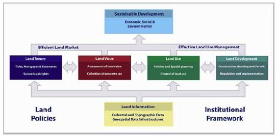
Diag 1 (Stig Enemark 2004)
The Global Land Management model
Secondly, delivering land plots and upgrading infrastructure
requires an interdisciplinary approach, supported by effective ways for
community participation in the planning and decision-making.
The above, Sustainable Places, Partnership working, and
Professional’s skill capacity are discussed in the next three sections.

3 Building Sustainable Places
The economics of housing recognises that it is easy for
governments worldwide to mix two different drivers: the need for
accommodation (to combat homelessness and overcrowding) with the demand to
own a home close to friends, family and work (fuelling un-affordability). So
our objectives must be clarified in order to distinguish between policy that
affects social need and market demand.
In line with the UN Millennium Development Goals, people require
spaces to live in decent living environments. Informal settlements develop in
small or large clusters in a haphazard jigsaw around a city. Consequently, the
expense of extending social infrastructure (water, sewage, roads and public
transport) is very high, and this situation becomes worse if settlements are
built on swampy land, hillsides or other unsuitable environments.
Poor people in informal settlements survive through their own
initiative, yet most of these initiatives are deemed illegal. Informal
settlements have over time evolved informal systems of land tenure relations and
management, despite the regulatory state.
The salient issues arising from Surveyors work relate to the
physical spatial environment. This is important because it relates to PLACES in
which people live. If governments do not provide sufficient land, the market
demand will continue to be met by informal settlements. Physical planning for
house plots and municipal services/ infrastructure, must be provided as the key
regeneration initiative.
The provision of a house structure cannot be seen as an end
product. Housing is, after all, part of a complex series of action steps and
policies that cuts across government departments. So if governance practices are
to be influenced, a holistic approach would be needed to bring about an
integrated economic, environmental and social development solution.
This will mean focussing precious resources in areas that will
count, and using information in such a manner that it supports pro-active
decision-making.
Issue 1: New Approaches to Spatial Planning
Cities are living dynamic entities, functioning much like a body
in which the streets are arteries and veins. They grow organically, and this
constant flow of innovation keeps them alive and expanding, thus they are
natural eco-systems of human beings (ref. 3). Surveyors have to work within this
dynamic.
Planners rely extensively on data, but by definition, the
informal economy is less likely to produce such information. A methodical
approach to planning also takes time; but a characteristic of informal
settlements is the speed at which they develop.
Together, these demonstrate that this chaotic and dynamic world
cannot be encompassed within the bounds of the current comprehensive
master-planning systems. Information technology has led to acceleration in the
speed at which we do things, for this, and other reasons, land allocation
methods need to change, especially in the ways that we use the appropriate
technology. The question is how to achieve this change within a highly complex
and interdependent social environment.
What surveyors can contribute
The focus should be to consider the regeneration and existing and
supply of new land areas, and ultimately the regeneration of sustainable
communities, in particular for housing plots. The effort should be concentrated
upon providing the necessary services to existing plots, as well as planning the
upgrading of new plots.
Simplistically, successful development is related to the
mobilisation of all parties and individuals. It is not a mere question of
infrastructure and economic drivers. To account for the complexities, a flexible
approach is necessary, informed by knowledge of the socio-economic environment
and social entrepreneurship. Surveyors could provide this cooperative knowledge,
providing a crucial link across the whole built environment professional team.
Issue 2: At the Crossroads – Appropriate Building
Standards and Regulatory Codes
Many building codes originated in colonial periods, and were
often imposed inappropriately on the African environment. In many cases, these
regulations are unchanged.
It needs to be acknowledged that people will continue to build
their own homes on an incremental basis, rather than employ contractors from
within the private sector. This is understandable. But input from governance is
necessary to ensure the appropriate use of materials and standards in order to
conform to health and safety regulations, as well as socio economic, ecological
and investment ties.
The path ahead is to address the effect of these out-of-date
codes on building materials and working practices and devise applicable codes
for the Regional environments.
What surveyors can contribute
It is now opportune to devise new codes, which acknowledge
alternative techniques and affordable building materials. Each individual
country could then mould and adjust the standards to take into account its local
needs. Surveyors could translate and communicate best practice in application
and technological quality control, as well as provide technological involvement
in the devising of the standards. Importantly, surveyors could ensure that all
people easily understand the codes.
Issue 3: Best Vehicles – to Improve Settlements
through Upgrading Mechanisms
It appears that national approaches have shifted away from
resettlement initiatives, towards upgrading and regenerating existing
settlements. But upgrading can only be effectively addressed when integrated
with environment, health and urban planning.
Upgrading needs tools and instruments that will actively involve
the community and respect their views. There are social and environmental
concerns to take into account. Living in informal settlements has serious
disadvantages such as the lack of public services like water, sanitation,
policing and emergency services. But plans must also ensure that the natural
environment is appropriately protected.
Importantly, upgrading tools need to be devoid of the
bureaucratic delays and lengthy approval processes that lead to excessive costs.
What surveyors can contribute
In-situ upgrading is an effective approach, in which we could
truly add value. This method is in line with ongoing initiatives such as UN
Habitat’s “Cities without Slums” that seek to implement urban planning and
management polices designed to prevent the emergence of slums, as well as the
upgrading of existing slums.
Thus, surveyors have the capability to identify specific factors
in each situation that appear to be holding back the process, but could be
readily addressed. Contemporary knowledge on regeneration suggests that a
project management approach is highly relevant because of its focused output.
This requires collaborative working across a number of areas, including process
management and regeneration. This mirrors the surveyor’s professional skills.
Issue 4: Highways – Creating routes for the Provision
and Development of Infrastructure
An infrastructure which includes pipe-lines, telecommunications
and public services is of utmost importance for a healthy, safe living
environment. Rapid economic growth and urbanization dramatically increases the
demands on Africa’s already inadequate infrastructure. What is now required is
action to close the infrastructure gap between the non-existent or dilapidated
conditions, and the needs of a growing economy and community.
However, it is becoming increasingly clear that the public sector
alone cannot bear the burden of supplying, managing and maintaining this
infrastructure. Private capital, technology and management skills are needed.
Global thinking has introduced the idea of ‘Public Private Partnerships in areas
where government could encourage private sector investment in energy/ power,
pipeline transmission, media and telecommunications, as well as fresh and waste
water.
©Nabutola/Kaiganaine
What surveyors can contribute
The focus of surveyors may relate to the provision of
infrastructure services, which will improve people’s welfare, as well as reduce
the degradation of the natural environment. Surveyors are well-equipped to
broker and advocate the areas where urgent engagement is required, namely
availability, affordability, accessibility and administration. We also need to
consider how appropriate technology and the use of information can be used as a
vehicle to support initiatives.
4 Building Partnerships
The pace of urbanisation is so rapid that new, culturally
sensitive ways need to be found to deliver land for housing. This involves
governments and communities working together.
There is evidence that the pressures of informal settlements are
largely (but not exclusively) occurring on traditional lands. There is a need to
instigate a pro-active dialogue to agree if and how administration systems can
operate in the future to release more land for housing. This dialogue may be
with chief owners or perhaps, as in peri-urban areas, by the head of families.
Rapid urbanisation has placed the urban poor in situations where
their struggle for survival is constantly in conflict with formal laws. But
contrary to common belief, access to squatter settlements is rarely free. An
entry fee must be paid to an intermediary, or to the person or group who extends
control over the settlements, so living in constant threat of eviction. It is
particularly severe for minority-headed households, such as women or children.
Without plots there are no places for people to build their
homes, so the emphasis of any review of how the land is administered must be
done with the involvement of people and their leaders.
Thus the strategic partnerships that have to be navigated
along the way are sophisticated, complex and politically difficult.
Issue 1: Driving with Traditional Leaders along
Parallel Tracks
Can ‘customary law’ as a system that is appropriate for
agricultural and socially-stable societies, cope with, urbanisation drivers,
globalisation forces and burgeoning populations which require access to secure
rights of occupation? Is it possible to spread more equally rights and
responsibilities to all society? What might be needed is a new approach that
recognises dual systems in parallel to civic government structures.
What surveyors can contribute
A key attribute of surveyors is their ability to understand,
create and analyse spatial data, but also importantly to communicate land
management, economics and planning into the social science. Surveyors are
skilled as facilitators, working with both professionals and non-professionals.
To facilitate the evolution of customary approaches, the role of
the surveyor lies in advocacy and support. Importantly, that role is not to
‘take over’. So there is a need to consider learning partnership programmes and
integrate these into regeneration strategies (ref 4).
Issue 2: Positive Passengers, a Participatory
Approach
Contemporary knowledge on urban development and managements
suggests that stakeholder participation in project conceptualisation, design,
implementation and management, could hold the key to sustainable urban
development. The process of engagement is dynamic, and it demands participation
(and ultimately responsibility) by stakeholders at all levels.
Consequently, if we want to successfully engage all stakeholders,
particularly politicians, we need to widen significantly the scope of our
professional understanding of the dynamics within communities. Above all, the
dialogue and participation have to be professionally-organised and managed in
line with resident and stakeholder expectations, including the media.
The aim is to prove that the democratic and administrative
renewal process is not hindered, and to avoid tokenism and non-participation at
all costs.
What surveyors can contribute
The surveyor’s ‘people skills’ are crucial here. We have the
ability to work with community members, then encourage the interest and
involvement of business enterprises from the earliest stages.
How we can make this happen:
-
Training of local communities and their leadership on land
management activities.
-
Assessing householders’ potentials to contribute to upgrading
costs and the options available to them (affordability).
-
Establishing the roles and responsibilities of stakeholders.
-
Integrating local grass roots institutions in infrastructure,
management and training.
-
Bringing together the wide and disparate inter-professional
disciplines that impact and contribute to the development of informal
settlements.
Issue 3: Steering through Knowledge and Information
Management
The global revolution in information technology is incredibly
dynamic and fast-moving, and the ability to utilise this is key in project
management and coordination. The use of GIS topographic mapping is a powerful
vehicle in the development of land policies that effectively incorporate
appropriate spatial data infrastructures. Yet many areas of the world lack the
fundamental map-based infrastructure that the developed world takes for granted.
The myriad of methods to access communication is only just beginning to be
translated appropriately into the planning and development sector.
A key enabling tool to the success of our working will be the use
of Geographic Information Systems (GIS) on urban areas. GIS mapping is a
powerful vehicle in the development of land policies that effectively
incorporate appropriate spatial data infrastructures. Yet many areas of the
world lack the fundamental map-based infrastructure that the developed world
takes for granted. Mapping-based services are seen to be a crucial part of the
delivery of the sustainability agenda.
What surveyors can contribute
The surveyor’s project management skills are critical to enable
disparate data sets and skills to be brought together in an interdisciplinary
and inter-professional manner. This involves partnering a range of stakeholders
including the international aid community, professional organisations, the
academic community, universities and key decision makers. A key area is for
surveyors to facilitate partnerships between the people who implement land
planning and those with technology expertise.
5 Building The Capacity
To be pivotal in making a difference, surveyors need to build
on their skills, both internally within the profession, and externally
within the wider built environment professional community. This section sets
how we can achieve excellence through utilizing our existing skills.
It is important to emphasise that the central thrust for the
delivery of sustainable places and urban regeneration will rely upon the
interaction of people and partnerships, and the use of appropriate tools.
Surveyors should apply their tools and professional knowledge to the problem of
planning urban areas that have started as a disorganised, incoherent pattern of
development (informal settlements). The skill sets are encompassed in a wide
economic-based, but holistic approach, termed here as regeneration.
Regeneration is an activity that creates a lasting improvement in
the social, economic, environmental or physical conditions prevalent within a
defined area.
As a profession we are extremely adaptable. Our skills and
knowledge processes take place in the context of different cultures and
climates, within different geographic, economic and political systems. Our
profession includes distinct but kindred disciplines of Measurement science,
surveying and mapping, spatial information management, land management, quantity
surveying and cost-control.
Theoretically, FIG has a number of opportunities to improve the
delivery of a range of themes; it has the particular advantage of being
established as a member’s organisation with good member country ‘sign up’. Thus,
with support, it could produce significant actions. Importantly surveyors need
to understand ‘how’ they can help. But it is recognised that it is unrealistic
to expect the surveying profession to do everything, hence the need is for an
approach based on continuing our strategic alliances.
Where the strategic alliances lie
The main stakeholders to be influenced as a result of the
surveyors work in this context are:
-
Politicians, who need to consider the legal and regulatory
(business) environment for the building materials production sector.
-
Investors/financiers, who need to be encouraged to invest in
business opportunities.
-
Small, Medium and Small Enterprises , who need to be
convinced of the market viability.
-
Donors, who should see the opportunity of supporting FIG/
professions to take the next step.
The aim should be to develop a greater understanding of the
demands and requirements of a broad spectrum of professional working, and seek
to identify ways to bind the different professions and occupational backgrounds
together.
Partnership working requires an innate understanding of each
other’s aims, objectives and aspirations. To work toward more effective
partnerships, the working group recommends that Surveyors:
Understand the meaning and intentions of partnerships.
-
Identify the challenges and appropriate tools for
partnerships.
-
Integrate with partnership processes demanding cultural change.
The management culture and internal organisation of local government should be
better focussed towards integrated partnership working and the shared outcomes
of sustainable places.
-
Continue professional learning.
FIG needs to continue its work with the range of UN initiatives
already underway. The UN Habitat branches in Urban Governance and Security of
Tenure are our particular focus.
Overall is the need to link with the Global Land Tool Network
(GLTN). The aim of this network is to “establish a continuum of land rights,
rather than just focus on individual land titling, improve and develop pro-poor
land management as well as land tenure tools, unblock existing initiatives,
assist in strengthening existing land networks, improve global coordination on
land, assist in the development of gendered tools which are affordable and
useful to the grass roots; and improve the general dissemination of knowledge
about how to implement security of tenure” (ref 6).
Much of this parallels the surveyors´ own aspirations. In
particular, the core values of GLTN are representative in the cross-cutting
themes highlighted in this statement, including good governance, pro-poor
activities, affordability, equitable and gendersensitive approaches and
solutions.
All built environment professionals have invaluable expertise and
a key role to play. It is essential that surveyors work with multi-disciplinary
teams and with local partners to achieve regeneration of Places for People.
6 Conclusions
Working with communities to identify the road ahead can
contribute to a socially cohesive approach within informal settlements.
Surveyors should move on from passive acceptance of the situation to active
engagement to drive toward meaningful solutions.
Surveyors have a unique set of skills, and are well placed to
find and facilitate solutions to the urbanisation process typified within
informal settlements. Taking a holistic, strategic approach, we can bring all
issues together and focus on informing policy and practice.
The working group concludes that the Surveyors role in informal
settlements is to:
-
Facilitate decision-making that combines the economics of
land development with the use of land, in a spatial and social context, and
as highlighted in this WG statement.
-
Seeks to deliver plots for people to build their homes.
The WG strongly recommends the following work activities relating
to spatial planning and development within Informal Settlement issues
into the next FIG term:
-
Spatial Planning and upgrading methods and regeneration tools
for access to, and equitable distribution of resources for the provision of
house plots on customary land.
-
Coastal Settlements and Climate Change, and Coastal flood
disaster preparedness and working with coastal communities.
Further ongoing linkages and liaison have been identified in
other Commissions concentrating upon participating with:
-
Commission 3 to support the work on the use of SIM- tools for
decision makers and citizens and the development of the use of appropriate
data sets and technology.
-
Commission 7 on the partnership between FIG and UN HABITAT within
the framework of the Global Land Tool Network
-
Commission 10 to Support the potential work on technical and cost
issues to explore affordable building materials, and appropriate regional
standards and codes, specifically for housing in developing and emerging
economies.
Appendices and References
1 Abbreviated References and Glossary of Terms used
-
WUF 2002, Nairobi
-
Professor S. Enemark 2004 - Aguascalientes Statement, FIG
Publication #34
-
Jane Jacobs reported in Economist 13/5/06
-
Turner & Townsend Group, Toward more Sustainable Places, RICS
Foundation 2004
-
Sherry Arnstein, WUF 2004.
-
GLTN http://www.gltn.net
CASLE - Commonwealth Association of Surveyors and Land Economists
GIS - Geographic Information System
GLTN - Global Land Tool Network
SIM - Spatial information management
UN MDG - United Nations Millennium Development Goals
http://www.un.org/milleniumgoals/goals.html
WUF - World Urban Forum
2 Working group Members
-
Diane Dumashie, Chair
-
Wafula Nabutola
-
John Parker
-
Rob Mahoney
-
Kari Strande
-
Richard Grover
3 Author References from FIG Technical sessions
Emmanuel O Akrofi (Ghana) Rashid M Azzan & Said S Ufuzo
(Zanzibar, Tanzania), Paul Chege (Kenya), Diane A Dumashie (UK), Ibrahim U
Jibril (Nigeria), Robin McLaren (UK), Wakuru Magigi (Tanzania), R Mahoney (UK),
Theodora M Mends & Johan de Meijere (Netherlands), Wafula Nabutola (Kenya),
Lason M Olayiwola & Olufemi Adeleye (Nigeria), Oyyat, Putsoa Alukoe, P Taylor
(UN Nairobi).
|