News in 2026

|
Surveying for Climate Resilience: Practical Climate Actions - New FIG
publication no. 85
February 2026
 |
This publication, Surveying for Climate
Resilience: Practical Climate Actions, spanning land, water, and
marine surveying – highlights the essential role of surveying
professionals in advancing climate resilience.
The publication is the result of the work in the FIG Climate
Compass Task Force (2023-2026) and offers practical strategies
and realworld examples to support climate adaptation,
mitigation, and disaster resilience at national and local
levels. With its 16 highlevel Climate Actions, this publication
marks a significant milestone for FIG.
The publication is written and edited by Chair of the Task
Force, Clarissa Augustinus. A large thanks to Clarissa for her
work with the task force, hereunder the preparations of the Regional Conference in
Nepal in 2024, her lead on the climate sessions at the recent Working
Weeks, and to compile all these findings into this significant
publication. |
Contributing authors of the publication are Uchendu Eugene Chigbu, Charisse
Griffith-Charles, Simon Ironside, Eranda Gunathilaka and Rigoberto
Moreno Vazquez. The other members of the task force who have supported
this work are Angela Anyakora, David Elegbede, Naa Dedi Tagoe, Cromwell
Manaloto, Enrico Rispoli and Maria Scorza.
Humanity is dealing with a global climate crisis, with
disproportionate impact on vulnerable regions, countries and people
especially in the global south. Surveyors have a major role to play
supporting the adaptation and mitigation of climate impacts at the
global, national and local levels. They can support the achievement of
the climate goals and environmental sustainability, economic growth and
the land rights of people. Practical surveying actions, methods and
tools for climate resilience, for land, water and marine are identified
in this publication.
Long-term geospatial and hydrospatial and land administration systems
data collection are foundations for territorial governance, in the
context of climate resilience. This data links the physical, legal,
economic and environmental dimensions. It provides vital information
for: Climate-related policy development; Long-term climate monitoring
and management; Identification of risks; Adaptation and mitigation
measures; Effective land, water and marine management; Support to
decision-makers managing the climate crisis. New technologies such as
geospatial databases, historical and current Earth Observation (EO)
data, large time series data analysis, AI tools, and other spatial and
temporal innovations have enhanced the surveyors’ critical role in the
management of climate impacts.
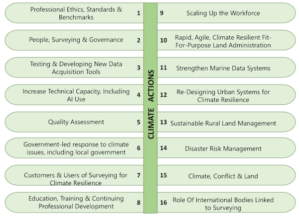
The 16 Critical Climate Actions of Surveyors, 2025.
Graphic courtesy of U.E. Chigbu
Many surveyors in the industry have traditionally supported the
USD287.6 trillion global residential real estate market. The climate
crisis is creating opportunities for surveyors, government, the private
sector, academia and industry to move to new business models that
support climate resilience. The development of these business models is
now a growing industry able to support multiple workflows going beyond
business as usual. Surveyors use of geospatial technology is evolving
rapidly to meet climate and disaster challenges, also as there are new
markets for their skills. Solutions need to cross the digital divide of
the global north and global south to ensure global and national
environmental goals are met for people and the planet.

Louise Friis-Hansen
5 February 2026